Cooler and Calmer
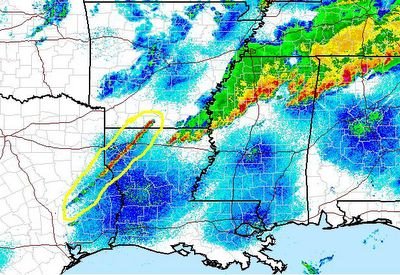
* What an active day yesterday. The SPC reported over 700 severe weather events (hail, wind, or tornadoes) yesterday...Before getting to the forecast, check out the severe weather reports from Mississippi and Alabama:
Alabama Severe Weather Reports
Mississippi Severe Weather Reports* Today's forecast looks like it's in good shape. Most places will stay dry, but a renegade shower or storm is possible. We saw a small thunderstorm across parts of Neshoba and Newton counties earlier, but it has since moved south and dissipated.
* Much of next week looks great - sunny and cool, only small rain chances for Wednesday. Looking at the latest guidance, we may have to remove those rain chances...I'll wait on another run before completely removing them, but rain chances are quite low. Temperatures will be pleasant, with highs in the upper 70's and lower 80's. Enjoy the nice weather!
4:30 AM Update
* There are still no active severe weather warnings for any of our counties in this area...But, we do have some fairly strong thunderstorms to talk about at this early hour...Those storms are clustered along a line from De Kalb to Decatur to Raleigh, and are quickly moving eastward.
These storms will impact much of Kemper, Newton, Lauderdale, Jasper, and Clarke counties over the next hour or so. You can expect frequent lightning and heavy rain as these storms move over, and the strongest of the strong might have a few hailstones mixed in with the rain.
After that, they will move on into west Alabama. Same story there...Some lightning and rain, perhaps a few wind gusts or hailstones.
Should we see any warnings, I'll let you know. Scroll down for my thoughts on today and a forecast update...
Late, Late Update
* What an active day across parts of the Southeast. Tornadoes struck parts of northern Mississippi, northern Alabama, and Tennessee. Sadly, 11 people lost their lives in a Nashville suburb. We will keep those affected in our prayers over the weekend.
* A tornado watch continues for most of our area until 4:45 am. Frankly, I think the tornado threat has diminished greatly across east Mississippi and west Alabama. But, let's stay aware of any surprises that may rear their head.
* I've amended today's forecast to include a shower or thunderstorm. The air aloft is going to be very cold, so that should touch off a storm here and there. With that very cold air aloft, I suppose there could be some small hail in some of the stronger cells. These "cold air aloft" setups can offer up some surprises, so we'll be watching closely.
* I'll have another update posted later today. Renny isn't feeling well, so I will be covering his shift this evening...
Fire Update
An update on the fire...
Marion Fire Dept. has confirmed a structure fire on Conehatta Street...The building was fully involved when the firefighters arrived...
**Weather Update**
The only active severe thunderstorm warning is for Kemper County; it expires at 2:45 AM (about 10 minutes)
Looking upstream, the squall line in western Mississippi seems to be weakening. I believe the new line in our area is probably cutting off its supply of warm, moist air.
Fire
* We just received a viewer report of a large fire near Marion -- possibly caused by a lightning strike. According to the viewer, emergency response vehicles are en route...The fire was visible from a half mile away...
2:15 AM Warning Update...
* Severe thunderstorm warnings continue for the following counties:
Jasper
Clarke
Lauderdale
Kemper
* If you live in those counties, expect heavy rain, lightning, and some hail is also possible. Strong gusty winds will accompany these storms. Stay inside and off of wired telephones.
2 AM Update
* I'll be doing a live update on Newscenter 11 just after 2 AM...But, here's the latest...
* Severe thunderstorms continue to fire across parts of east central Mississippi. Severe thunderstorm warnings have been issued along this entire cluster of thunderstorms, and currently include the following counties:
MISSISSIPPI
Jasper
Newton
Clarke
Lauderdale
Kemper
ALABAMA
Sumter
Pickens
Greene
Hale
* The squall line back near the river seems to be losing some intensity on its northern end...The southern end still looks intense though...
* Time to do an update...
Update
Here's the latest warning update:
Severe T-Storm Warnings:
Jasper
Clarke
Newton
Lauderdale
Sumter
Pickens
Tornado Warnings:
Kemper warning has expired.
Noxubee warning has expired.
Greene
New Warnings
* Severe Thunderstorm Warning for Greene County (AL) until 2 AM....Clinton is likely being hit by this storm as we speak...Hail is the main threat...
* Tornado warning for northern Kemper and southern Noxubee Counties until 145 AM. The possible tornado is moving along Hwy. 16 between De Kalb and Scooba....Folks in both cities need to take cover immediately...
* Severe thunderstorm warnings continue for Newton and Lauderdale Counties...
SVR Warnings
* NWS has issued a Severe Thunderstorm warning for...
Southern Kemper
Northern Lauderdale
Southeastern Neshoba
Northern Newton...
Quarter size hail is possible in this storm, as are winds in excess of 60 mph.
* This storm will affect Union, and extreme northern Lauderdale County....along and north of a line from Collinsville to Lauderdale...
Severe T-Storm Warning...
BULLETIN - EAS ACTIVATION REQUESTED
SEVERE THUNDERSTORM WARNING
NATIONAL WEATHER SERVICE JACKSON MS
1256 AM CDT SAT APR 8 2006
THE NATIONAL WEATHER SERVICE IN JACKSON HAS ISSUED A
* SEVERE THUNDERSTORM WARNING FOR...
NORTHERN KEMPER COUNTY IN EAST CENTRAL MISSISSIPPI
SOUTHERN NOXUBEE COUNTY IN EAST CENTRAL MISSISSIPPI
* UNTIL 145 AM CDT
* AT 1256 AM CDT...NATIONAL WEATHER SERVICE DOPPLER RADAR INDICATED A
SEVERE THUNDERSTORM CAPABLE OF PRODUCING QUARTER SIZE HAIL...AND
DAMAGING WINDS IN EXCESS OF 60 MPH. THIS STORM WAS LOCATED 12
MILES WEST OF DE KALB...OR ABOUT 14 MILES EAST OF PHILADELPHIA...
AND MOVING NORTHEAST AT 50 MPH.
* THE SEVERE THUNDERSTORM WILL BE NEAR...
6 MILES NORTHWEST OF DE KALB BY 105 AM CDT...
A TORNADO WATCH REMAINS IN EFFECT FOR THE WARNED AREA. SEVERE
THUNDERSTORMS CAN PRODUCE TORNADOES WITH LITTLE OR NO WARNING. IF A
TORNADO IS SPOTTED...ACT QUICKLY AND MOVE TO A PLACE OF SAFETY IN A
STURDY STRUCTURE...SUCH AS A SMALL INTERIOR ROOM.
Severe T-Storm Warning
* NWS Jackson is just about to issue a Severe Thunderstorm Warning for Kemper and possibly Noxubee County...
* More in a moment...
Warnings...
* Forgive the late nature of the post, things were hectic for a moment...
* Tornado Warning for Noxubee County has expired...No reports of damage with this storm...
* Severe Thunderstorm Warning continues for Pickens County, Alabama for about the next 10 minutes...This will likely be extended...
* Back to radar duty...
New Cells Forming...
* New cells are beginning to form in advance of the approaching line. These are running from extreme northwestern Leake County, northward towards Starkville. I believe that these will likely continue developing southward along a boundary through the next couple of hours.
* These cells have the potential to produce tornadoes, large hail, and damaging winds...
* They will not impact our area until after midnight.
We are watching a squall line form across northwest Louisiana...This will likely make the thunderstorms in northeast Louisiana speed up. This line will likely be a producer of large hail and wind damage as it moves eastward....

Where Are The Storms?
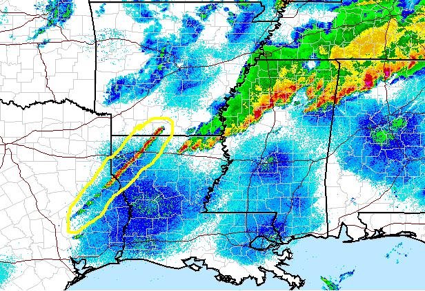
* You may be asking that question...They are running behind schedule by several hours. The current axis of thunderstorms runs from roughly Monroe, Louisiana to Tupelo, MS -- the northern end is pushing east, but the southern end of that axis is not making much of an eastward push.
* Here's the million dollar question...Will additional supercells fire in advance of the slowly approaching squall line? My opinion is that it's unlikely. The sun has gone down, so we have lost our daytime heating. This will lead to lower instability but higher low level wind speeds. The lack of instability will be the key factor, because the thing keeping thunderstorms from popping is an inversion, or "cap". Right now, I just don't see us breaking the cap. But, stranger things have happened - we'll monitor it closely.
* Bottom line: While we aren't out of the woods just yet, we may end up dealing with the squall line itself rather than supercells ahead of it. This would mean a diminished tornado threat, but still a threat of some large hail. The big story is that our timing will have to be adjusted - seems like it won't arrive here until after midnight, and could linger until sunrise Saturday.
Tornado Watch Issued
* Here is the new Tornado Watch. It is a "PDS" watch, which means "Particularly Dangerous Situation"...
http://www.spc.noaa.gov/products/watch/ww0169.html* This includes the every county in our area except for Clarke County, Alabama...
* It runs until 4 AM...
New Tornado Watch Forthcoming...
* The NWS in Jackson just shared this with us via Instant Messenger:
"FYI - just got off the phone with SPC. They are going to put another tornado watch out for the entire area...except Hattiesburg-Purvis-Columbia. It will be a PDS box."
I'll post the watch as soon as it is available...
EDIT: NWS Jackson let us know that the watch will be in effect until 4:00 AM.
Bad News North of Here
* The
Nashville Tennessean is reporting that 7 people have lost their life in the tornadoes that struck middle Tennessee earlier this afternoon...Very sad stuff.
* We are getting many damage reports in from the Mississippi Delta - scroll down for some links to check out the damage reports for yourself.
* A new tornado watch has been issued for Louisiana. We'll have to watch things closely in this watch area, because these storms will eventually affect us later tonight.
* Timing hasn't changed since my last update - 8pm until 3am is the timeframe we're most concerned about.
Damage Report...
* NWS Jackson has relayed a report of "significant damage" in Cleveland...
* For a full listing of damage reports, check out the links below:
Alabama Damage Reports
Mississippi Damage ReportsTennessee Damage Reports
Supercells Developing...
* Supercells are beginning to develop across parts of northern Louisiana, western Mississippi, and southern Arkansas. Some of these have had funnel clouds reported with them, while others have had very large hail. We suspect that these reports will really begin to fly in fast and furious over the next several hours.
* The corridor we are watching is from Natchez back towards the southwest. That's the area that storms may fire and move northeast into our area later tonight.
* We are going to push back our timing; things have been slow to develop - we'll now go with the idea that we'll be dealing with bad weather between 8:00 pm and 3:00 am.
* CHECK this out:
http://www.wtok.com/weather/radarloopThis is Java-based radar loop we've been working on lately. You can zoom in, stop the radar loop, and it also shows severe weather warnings. A fun tool, be sure to check it out!
* Back to watching the radar - more updates coming on Live at Five and Newscenter 11 at 6...
Latest Information...
* Tornadic supercells continue across much western Tennessee...Trained spotters have reported tornadoes on the ground there. Those supercells look very, very intense and are probably producing hail the size of baseballs.
* We are watching the corridor from Shreveport to Memphis closely. This is the corridor where we expect supercells to begin to develop over the next couple of hours. These will then move east, and affect most of our area. Until they actually form, it will be tough to say exactly where and when the bad weather will affect us. I'll take a stab at it now, but know that this can and probably will be adjusted as we move through the rest of the day:
TIMING: Supercells will move from west to east between 6:00 pm and 11:00 pm. PLEASE understand that this is not an absolute range - there is the potential for things to erupt sooner or last longer - this is just a guide.
LOCATION: The greatest threat of tornadoes in our area will come along and north of U.S. Highway 80 - but you should know that there is at least some threat of tornadoes today across most of our area.
WHAT TO DO: First, don't panic or be scared. There's no need. You simply need to have a way of getting weather warnings - NOAA Weather Radio is the best option. You can buy one at a local consumer electronics store.
You need to also have a pre-determined safe place in your home that every family member knows and will go to in the event of a tornado warning. A basement works best, but an interior bathroom, hallway, or closet on the lowest floor works well too.
I know we've said that a lot, but the last two paragraphs are the most important part in all of this. If you live in a mobile home, tonight would be a good night to spend with a friend or relative who lives in a more substantial structure.
School Closings
Here are the latest school closings I've received:
Friends of Children Head Start in De Kalb will close at 1:00 pm.
Kemper County Schools will close at 1:30 pm.
Lauderdale County Schools will close at 2:00 pm.
Scott County Schools will close one hour early.
Forest City Schools will close one hour hearly.
Neshoba Central High School will close at 12:45 pm.
Neshoba Central Elementary School is closing right now (12:30 pm).
KidZone Daycare is closing as soon as parents can come get their children.
* If you have any additions and/or corrections to this list, please leave a comment below or email josh.johnson@wtok.com.
Tornado Watch
* Here's the link to the new tornado watch:
http://www.spc.noaa.gov/products/watch/ww0163.html* This is a "Particularly Dangerous Situation" tornado watch...Here is an excerpt:
DISCUSSION...VERY POTENT TORNADIC SUPERCELL ENVIRONMENT IN PLACE LOWER MS VALLEY AS STRONG UPPER TROUGH AND SURFACE LOW MOVE EWD ACROSS CENTRAL AND SOUTHERN PLAINS. STRONG DEEP LAYER SHEAR...VERY STEEP MID LEVEL LAPSE RATES AND MLCAPES IN EXCESS OF 2000 J/KG WILL LEAD TO RAPID DEVELOPMENT OF SEVERE THUNDERSTORMS VICINITY LOWER MS VALLEY EARLY THIS AFTERNOON. TORNADIC SUPERCELLS ARE EXPECTED WITH POTENTIAL FOR VIOLENT/LONG TRACK TORNADOES AS ACTIVITY DEVELOPS EWD ACROSS WATCH AREA THRU THE EVENING.* They also mention the possibility of hail the size of grapefruits (4" in diameter-larger than baseballs)...Scroll down for more info....
Tornado Watch
* The SPC has issued a Tornado Watch until 8:00 pm for the following counties in our area:
Mississippi:
Scott
Leake
Winston
Neshoba
Newton
Noxubee
Kemper
Lauderdale
Alabama:
Pickens
Sumter
Greene
Hale
* This watch extends far back to the north and west, and includes Jackson, Vicksburg, Columbus, Starkville, Tupelo, and others...It also includes cities east of here, including Tuscaloosa and Birmingham.
* We are in constant communication with the NWS via IM...Here are their thoughts this morning...
"everything looks to be coming together for an extremely active...dangerous day across our area. we did a special 15Z sounding that showed the low level moisture deepening...and extremely steep 8.2 C/km lapse rates."
* Let's reiterate that there is no need for any kind of panic or scare. Have a way to get the warnings, and a pre-determined place in your home to go during a tornado warning - basement works best, if you don't have one, use an interior bathroom, hallway, or closet. Take care of both of those, and you'll almost assuredly be fine.
* Another point - hail could be a big problem today. I would imagine golf-ball size hail reports will be commonplace, and there could be a report or two of baseball size hail across north Mississippi. So, today is definitely a good day to park your car in your garage if you have one.
Mesoscale Discussion
* The SPC has outlooked the northern half of our area under their latest Mesoscale Discussion. They say they will likely issue a tornado watch for parts of central/northern Mississippi and into Alabama in an hour or so...
http://www.spc.noaa.gov/products/md/md0454.html

Boundaries like these (shown by a thin yellow line) often play an important part in storm development and tornado initiation. We will be closely monitoring the progress of these boundaries through the day. Scroll down for additional information...
Morning Update
* I have been reviewing the latest data, and the thinking is still unchanged. Today will likely be an active weather day, with the threat of large hail, damaging winds, and tornadoes. The best chance of tornadoes will likely come along and north of U.S. Highway 80, but they certainly can't be ruled out farther south.
* Please note that we say this will "likely" be an active weather day. It's also possible, but not likely, that this could bust and little or nothing will happen. That seems rather unlikely, but it is possible. And, it's the scenario for which I personally vote.
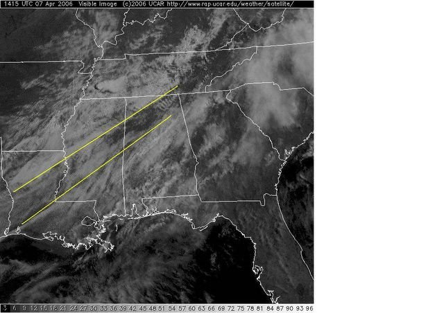
* Dewpoints have surged into the middle 60's - those will not be a problem today. A review of area soundings shows fairly ominous upper air data out of Jackson. A key today will be the area with the greatest shear in the lowest levels of the atmosphere. Local boundaries will play a big role in enhancing that shear. Right now, there are two boundaries draped across the Southeast. One that runs across north Mississippi and north Alabama, and another, weaker boundary that runs roughly from Natchez to Meridian to Birmingham. I'll post an image of these boundaries in a few minutes, so you can see them for yourself...
New Day 1 Outlook
* The new SPC Day 1 outlook has shifted the high risk a bit farther north. This is likely in response to the 0z model suite, which indicated that the best low level shear would be along the Highway 82 corridor. If that verifies, we could be dealing with more of a hail threat than a tornado threat here. But, this is a model forecast - not real data. It could be wrong. I want to stress that the threat for our area is still significant and that it is far too early to let our guard down.
* The location and presence of mesoscale boundaries will determine the progression of the event as we go through the day tomorrow. These boundaries enhance low level shear, and increase the likelihood of tornadoes.
* Time for a quick nap. I will be up tomorrow morning and will post more information at that time...Sleep well!
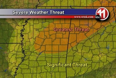
The greatest threat of severe weather and especially tornadoes will come roughly along and north of Interstate 20. However, I must stress that there is a substantial threat of severe weather across all of our area. The threat simply increases to the north...
Here's a graphic showing our current thinking...
Evening Thoughts
* All evidence still points towards a significant threat of severe weather tomorrow afternoon and tomorrow night...Here's my thinking:
TOMORROW: Showers and supercellular thunderstorms will develop early tomorrow afternoon across eastern Arkansas, northern Mississippi, and western Tennessee. These will likely be severe. As we go through the afternoon, more supercells will fire across central Mississippi, and these will begin moving quickly in our direction. These will likely be severe, with large hail, damaging winds, and tornadoes all possible.
TOMORROW NIGHT: Supercells will continue through much of the evening hours, with the continuing threat of severe weather. After the supercells move east out of our area, a trailing squall line will sweep through. Large hail will be the main threat with this line, but tornadoes would still be a possibility within this line.
DETAILS: Tornadoes are a big concern across northern parts of our area. The farther north you go, the more supportive the shear profile is of tornadoes. Large hail is also going to be a huge concern - the air aloft is very cold, and freezing heights are at a very favorable location in the atmosphere. Damaging winds are a secondary threat.
QUESTIONS: The main question involves storm mode - will we see supercells, or just a squall line? With discrete supercells, the tornado threat would be greatly enhanced. At this point, I lean towards supercells forming ahead of the main squall line.
Another question will be the placement and evolution of mesoscale boundaries. Things like outflow boundaries, differential heating boundaries, etc. These won't make themselves apparent until tomorrow.
WHAT TO DO: First, don't panic or be scared. Just make sure you have a way to get warnings, and a safe place to go in the event of a warning. If you take care of both of those, you will almost assuredly be fine. Tomorrow will be a good day to stay close to a good source of weather information.
NEXT UPDATE: I will post a quick update tonight just after midnight, after I've had a chance to fully evaluate the 0z (evening) model guidance.
No Need For Panic
* I've received quite a few phone calls and e-mails from people who seem a bit "spooked" about the severe weather threat tomorrow evening. I'd like to say up front that there's no need to panic or be afraid. Right now, this is only a threat - a threat that has not materialized yet. And, if you have a way to get warnings and a safe place to go, it's almost a certainty that you'll be fine.
* At the same time, I do think you should be aware of the threat - and stay close to a good source of weather information tomorrow...
* This space will be frequently updated throughout the event, so be sure to check back for updates...
* Speaking of updates, I'll post a big one this evening before 9 pm.
Quick PM Update
* Everything is still pointing towards a significant severe weather episode tomorrow. The 18z computer model guidance is coming in as we speak, and the NAM shows almost no change. The GFS will start trickling out within the hour...I'll review it and post a full update later this evening.
* Sure wish I had about 18 arms today. Between forecasting, coordination conferencing, building weather graphics, and other TV related duties, it's rather difficult get it all done in a timely fashion. But, I enjoy working hard, so it works out well.
* I will be updating this space as much as possible during the night tonight and tomorrow. We will be a little short-staffed, as Renny Vandewege is under the weather and will not be able to assist us here. I hope Renny gets to feeling better soon.
* I would like to again reiterate that now is the time to go through your severe weather safety plan. If you don't have a plan, it's simple - have a way to get the warnings, and pick a safe place in your home to go to when a warning is issued. The best way to get warnings is a NOAA Weather Radio (available at any consumer electronics store). Basements work best, but interior bathrooms, hallways, and closets on the lowest floor of your home make good shelters as well. Abandon mobile homes and cars and take cover in the nearest ditch or substantial structure.
Day 2 High Risk

* The Storm Prediction Center has issued a very rare Day 2 High Risk for much of northeast Mississippi, north Alabama, and Tennessee. They are forecasting a signficant outbreak of tornadoes, some of which could be strong. While we are not in the high risk, it is very close to us. These risk areas are rough approximations, and I would not be surprised to see areas north of U.S. Highway 80 included in the High Risk in later outlooks.
* Please take this time to review your severe weather safety plans in your home, school, and business. If you live in a mobile home, you may want to consider spending time with a friend or relative in a more substantial structure. The timeframe of concern is from around 2pm until midnight.
* Stay close to a good source of weather information tomorrow, it has the potential to be a bad day.
Noon Thoughts
* My thinking on the severe weather event tomorrow is mostly unchanged. The 12z (morning) computer model guidance is in, and it looks remarkably consistent to the runs from yesterday.
* We've been busy with IM coordination conferences today. Here are some highlights of our conference with NWS Jackson:
We have a local tornado outbreak checklists that goes from 0-84 on a point system. This comes up with 73 at KJAN. It uses historic KJAN upper air data for tornado outbreaksin the CWA. Doesn't help specify area, just that big severe can occur in CWA. Obviously area north of I-20 looks most favorable but we shall see. May be capped in SE MS given 8.5 c/km 700-500 mb lapse rates, at least during the day. * The evidence still suggests that the worst of it will likely come north of U.S. Highway 80, as discussed early this morning.
* The new SPC Day 2 Outlook should be issued soon...I will post it as soon as it is available...
Moderate Risk

* The SPC has issued a
Moderate Risk for our all of our area. They also use the
rare 45% hatched risk area - their way of saying this one could be a significant episode. I wouldn't be surprised if parts of this Moderate Risk area were upgraded to a High Risk early Friday morning. If I had to guess, I'd say along a corridor from Greenwood, MS to Huntsville, AL...
* Also, I have uploaded Thursday's Podcast.
It includes some national highlights and our thoughts on the severe weather potential tomorrow...Check it out:http://media.graytvinc.com/audio/Podcast1.mp3* You can point your IPod or MP3 receiving program to this RSS feed in order to subscribe:
http://feeds.feedburner.com/11Podcast* Be sure to scroll down for a thorough analysis of the severe weather threat...
Midnight Musings
* Forgive me for being late (and lengthy) with this post - I have really been doing a detailed evaluation of the 0z (evening) computer model data. Here are my findings:
PROGRESSION: A closed upper low will become an open trough as it swings southeast from Kansas towards the lower Mississippi Valley. A surface low will also track southeast, along roughly the same track as the upper trough. If that's correct, the surface low would be weakening a bit as it moves eastward. However, I believe the upper trough will likely be a bit farther north, which would keep the surface low fairly intense.
This low will bring a surface front through late Friday, which will interact with a very "primed" atmosphere. Instability values are forecast to be in excess of 1500 J/kg on both the GFS and NAM, with cold air aloft.
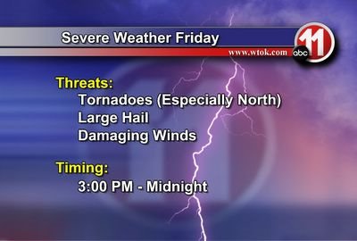
Showers and thunderstorms will first fire across northern Mississippi, with activity developing southward through late Friday and into Friday evening. The extent of this southward development is a key issue - I believe the thunderstorms will develop as far south as Highway 84. The best area for severe weather seems to be along and north of U.S. Highway 80 - including but not limited to Philadelphia, Carthage, Newton, Meridian, Scooba, De Kalb, Livingston, York, Eutaw, Demopolis, and Aliceville. The time of maximum concern seems to be from 3pm Friday to midnight Friday night. That's a flexible time frame that could be adjusted later.
MODEL OUTPUT: First, a quick note on severe weather forecasting: it's hard. Also, it's very important to know that severe weather parameters are great forecast tools, but should never solely constitute a forecast. That being said, let's evaluate some of the model-derived forecast parameters:
The NAM is much more troubling than the GFS. It brings
our CAPE well above 2000 J/kg, with intense shear. The Energy Helicity Index incorporates both of these, and the NAM forecasts the EHI to approach 5 by Friday evening. Anything over 2 is favorable for a significant severe weather event. Also, the hodograph, a graph of wind speed and direction at various heights in the atmosphere, is forecast by the NAM to be very favorable for supercells and tornadoes.
The GFS is less impressive with the instability and dynamics than the NAM, but still gives us reason for concern. It shows CAPE values over 1500 J/kg, with an EHI approaching 3. Again, 2 is a rough estimation of when the atmosphere is supportive of supercells and tornadoes.
QUESTION MARKS: There is some uncertainty about if our atmosphere will remain "capped" or not. The GFS computer model says that at least a small inversion will be present in the lowest levels, while the NAM indicates otherwise. The GFS has been more accurate than the NAM lately, but I'm leaning towards the NAM solution. The reasoning for that is the favorable surface low track and plentiful warm, moist air. Dewpoints will be in the middle to upper 60's, which is quite favorable for severe weather.
THINGS TO WATCH: First, we'll have to carefully watch the intensity of the surface low as it pulls through the southern Plains and into the Ohio Valley. The stronger the surface low, the higher our chance of severe weather.
Secondly, we must watch for sunshine on Friday. This will serve to destabilize the atmosphere even more, and could also create some differential heating boundaries. These boundaries are created along the line between places that have cloudy skies and those who have sunny skies. The sunny area gets warmer, and a temperature boundary is created. This boundary can serve to enhance the environment for severe thunderstorms.
* The bottom line is that severe weather seems likely Friday afternoon and Friday night. Please arrange to stay close to a good source of weather information Friday. The best way to get severe weather information is a NOAA Weather Radio, which can be purchased at any consumer electronics store. If you live in a mobile home, please stay aware of the latest weather info. In fact, Friday night might be a good night to spend with a friend or relative who lives in a more substantial structure. Remember, the vast majority of tornado fatalities in Mississippi and Alabama occur in mobile homes.
* Scroll down to check out the forecast
Significant Tornado Parameter...
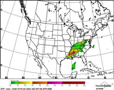
This is the Significant Tornado Parameter forecast from the NAM, valid at 10pm Friday. This would suggest the possibility of some tornadoes across our area. While we believe a good forecast should never be based solely on parameters, this output is still concerning.
Quick Evening Update
* The 18z computer model guidance is in...Here are some severe weather parameters from the 18z (afternoon) run, valid 0z (7 pm) Friday:
Sfc Temp: 78
Sfc Dewpoint: 69
CAPE: 2476.2 J/kg
0-3 SRH: 247.2
Lifted Index: -8.2 C
850mb wind speed: 49 knots
* These numbers suggest ample instability, but the amount of shear is in question. This depends on the exact track of the upper trough....At this point, the best shear could well end up north of here....That's something we'll have to monitor closely...
* I'll have a full update tonight around midnight, when the 0z model guidance has completed....
Severe Weather Threat?
* It sure looks like we'll need to beef up our wording about the potential for severe weather Friday and into Friday night. The last couple of model runs have brought the surface low and best upper level support a bit farther south. This would indicate an increased chance of severe thunderstorms.
* The NAM (North American Mesoscale) model indicates a rather strong surface low, on the order of 996 millibars. But, the GFS (Global Forecast System) model shows a much weaker surface low, with a minimum pressure of around 1004 millibars. Lower pressure = higher severe weather threat. It should be noted that the GFS has outperformed the NAM over the last few months.
* It's too early to really define the main threat with this system. For now, we'll just go with the broad-brush idea that large hail, damaging winds, and even some isolated tornadoes are possible. The tornado threat will hinge on what type of storms we're dealing with: isolated supercells would have a greater threat of tornadoes than a squall line.
* Timing: The time of maximum concern comes between noon Friday and midnight Friday night. We'll try to narrow that down a bit tomorrow.
* I'll closely review the afternoon and evening model guidance and post an update here later this evening....
2006 Hurricane Seasonal Forecast
* Here's Dr. William Gray's forecast on the 2006 hurricane season. Dr. Gray is one of the world's most brilliant hurricane researchers, and he is predicting an above average season again this year...He also goes out of the way to stress that global warming is not the cause of these active hurricane seasons.
http://hurricane.atmos.colostate.edu/forecasts/2006/april2006/
Podcast: Wednesday Edition
* This is the Newscenter 11 Podcast - a forecast designed for the increasingly popular IPods! This product can also be played on most personal computers. It's a great way to get extra forecast and weather content at your convenience.
* In Today's Podcast, we briefly touch on some national weather highlights, including some flooding problems in California. And, as always, your complete forecast...Check it out:http://media.graytvinc.com/audio/Podcast1.mp3* You can point your IPod or MP3 receiving program to this RSS feed in order to subscribe:
http://feeds.feedburner.com/11Podcast
Enjoy It While We Can
* As the title of this post suggests, that is exactly what we must try to do. Today has featured ample sunshine and temperatures running in the middle 70's. It won't be long before we are suffering through the sweltering heat and humidity of summer in the South. So, try to enjoy this nice weather while it's still available!
* Much of the week is going to feature fantastic weather. Clouds will increase a bit tomorrow and tomorrow night, as a weak disturbance passes overhead. There is not enough lift or moisture to produce rain with this feature. It won't be overcast, just a few more clouds out there.
* Thursday looks great, but changes get underway Friday. An area of low pressure will form over the central Plains. This will pull northeast towards the Great Lakes, dragging a cold front towards us. At this point, it seems that our threat of severe weather is low with this feature. But, we can't rule out a few strong thunderstorms as the front moves through.
* The weekend looks nice - a few showers may linger early Saturday, but most of the weekend will feature a mix of sun and clouds with comfortable temperatures...
* 11 1-Liners for Tuesday
- Winter Storm Watches are up for the Colorado Rockies.
- They expect over two feet of snow.
- It can snow here in April.
- Birmingham, AL picked up 6" of snow on Apr. 3, 1987.
- NWS has rated the Dyer County, TN tornado an F3.
- This rating is preliminary.
- Nearly 30 people have died in the tornado outbreak.
- The national media has said the people had "little warning".
- That is incorrect, these storms had excellent warnings.
- The damage is indescribable - Click here for images.
- Our prayers still go out for those affected.
Podcast: Tuesday Edition
* This is the Newscenter 11 Podcast - a forecast designed for the increasingly popular IPods! This product can also be played on most personal computers. It's a great way to get extra forecast and weather content at your convenience.
* In Today's Podcast, I talk about mountain snow and the unreal cold temperatures in parts of the world! And, as always, your complete forecast...Check it out:http://media.graytvinc.com/audio/Podcast1.mp3* You can point your IPod or MP3 receiving program to this RSS feed in order to subscribe:
http://feeds.feedburner.com/11Podcast
Tranquil Week Ahead
* I'm gearing up for the big national championship showdown between Florida and UCLA. While Florida is the popular pick to win it all, I can't help but pick the defense and tradition of UCLA...I'll go with UCLA 59, Florida 52. But, I'm certainly no sports expert.
* LET'S TALK WEATHER: Cooler air headlines our forecast. A cold front is roaring southward towards the Gulf coast, and this front will usher in some cooler temperatures tonight and tomorrow. We're not talking about anything unusually cold, but temperatures will get back closer to normal. Highs tomorrow will likely reach the lower 70's.
* NICE week ahead... The majority of the work week looks pretty good. A weak disturbance will pass overhead Wednesday, bringing a few clouds to the Southeast. No rain is expected, as moisture will stay rather limited. Thursday looks sunny and warm, but changes arrive soon...
* Thunderstorms Possible Friday: A deep upper trough will rotate out of the western U.S. and into the central Plains. This will spawn a surface low that will track well northwest of us, but will drag a cold front through here Friday. While it's still several days away, this sure looks like a favorable severe weather setup across parts of the Plains and Ohio Valley. The southward extent of the severe weather threat is in question. We will keep a wary eye on this system...
* Keep an eye peeled on this space over the next couple of weeks. I am working on some great new ways for you to get weather information - should be fun!
* Things have been rather busy today, I've been running behind all day. Here's a strange report from the NWS regarding a severe thunderstorm in North Carolina. Note the hail size...
PRELIMINARY LOCAL STORM REPORT
NATIONAL WEATHER SERVICE GREENVILLE-SPARTANBURG SC
427 PM EDT MON APR 03 2006
..TIME... ...EVENT... ...CITY LOCATION... ...LAT.LON...
..DATE... ....MAG.... ..COUNTY LOCATION..ST.. ...SOURCE....
..REMARKS..
0730 AM HAIL FALLSTON 35.43N 81.50W
04/03/2006 E1.00 INCH CLEVELAND NC POST OFFICE
BIG THUMB SIZE HAIL IN FALLSTON AND LAWNDALE FROM 730 TO 8 AM.
* I will write a complete forecast update later this evening, before 9:00 pm. Scroll down for some unbelievable radar imagery from yesterday's terrible thunderstorms. The death toll is nearing 30 with the tornado outbreak...How tragic. Our thoughts and prayers go out to those affected by the powerful storms yesterday.
Podcast: Monday Edition
* This is the Newscenter 11 Podcast - a forecast designed for the increasingly popular IPods! This product can also be played on most personal computers. It's a great way to get extra forecast and weather content at your convenience.
* Today's Podcast discusses the tragic severe weather episode that occurred yesterday. And, as always, your complete forecast...Check it out:http://media.graytvinc.com/audio/Podcast1.mp3* You can point your IPod or MP3 receiving program to this RSS feed in order to subscribe:
http://feeds.feedburner.com/11Podcast
Caruthersville
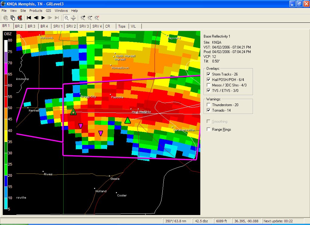
* It hurts to report that the town of Caruthersville sustained significant damage from a tornado. Turns out the bad feeling I had seeing those images (see below) were for good reason. I think we should all say a little prayer for the folks of Caruthersville as well as all of the other towns that have received damage or injuries from tornadoes today. We'll see how many reports come out, but it certainly doesn't look good....
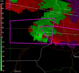
This is a somewhat disturbing image of a tight rotation near Caruthersville. Notice the purple triangle. That is a tornado vortex signature (TVS). It is basically an algorithm that detects what the radar thinks is a tornado. The red colors are particles moving away from the radar and the green colors are particles moving towards the radar with the Memphis radar being south.

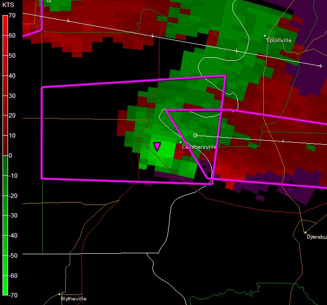
This is a classic, scary hook echo with a confirmed tornado moving right towards the town of Caruthersville, MO. Hopefully it lift before it hits them.
Severe Weather Outbreak
* Things are really getting active north of here today. A possible tornado in the St. Louis metro area. As of just before 5:00pm, there are 36 severe thunderstorm warnings and 17 tornado warnings! The warm front is having a huge impact on these storms and providing a large amount of shear for the storms!
Also a report of hail in Arkansas of 4.25 inches! That is enormous! It caused structural damage.
* I'll continue to keep an eye on what is going on up there as well as making sure things are going well here too! Beautiful weather out there right now!
Warm Day!
* It's a warm one out there today! We have made it to 87 so far today, nearing our record high of 88 for this date. I wouldn't be surprised to at least tie or break that record as we are nearing peak heating! Tomorrow looks warm as well as highs are still in the lower 80s before we cool off a bit for Tuesday with highs in the lower 70s.
* There is a slight chance of a shower or thunderstorm tonight however I think the best threat stays off to our north and west. Places northwest of the Natchez Trace have the threat for an isolated severe thunderstorm tonight.
* Speaking of severe weather...some explosive development is ongoing in Parts of Missouri, Iowa, and Illinois with more discrete, isolated development to the south. These are probably some of the fastest developing storms I have ever seen! Radars up there went from scan free to lit up like a christmas tree in the matter of about 20 minutes. The main line of storms is moving towards the warm front in eastern Missouri, near St. Louis. This front will provide added low level turning of the winds and I wouldn't be surprised to see some of these severe thunderstorm warnings turn into tornado warnings within the next hour or so!
* Enjoy the warm and sunny weather!


