Saturday Afternoon
* Had to turn on the A/C in the car today! It's a warm, windy, muggy afternoon out there today. Impressive Gulf return flow is pumping moisture all they way into northern Missouri and Illinois. That area of the country is looking at a threat for severe weather today as small impulses of energy eject out of the western US trough and kick off thunderstorms. It looks like that area will be under the gun again tomorrow so if you do have travel plans to St. Louis or Little Rock, be sure to turn on a radio station for the latest weather information
* Around here, one thunderstorm has developed in northern Neshoba county. Probably a brief period of heavy rain along highway 15 between Philadelphia and Noxapater. We think that will be the trend today. Very widely scattered showers or thunderstorms. Certainly not an all day rain event. One or two storms could become strong, but again the threat of severe weather is well off to our north and west where the combination of instability and upper level dynamics will get things going!
It Finally Rained...
* Great to see this news for our friends in Phoenix, Arizona...They had been experiencing a dry spell like none other! This is one type of worry we'll never have around here:
143 days without rain! Here's the link:
http://www.azcentral.com/news/articles/0311RainFinally0311.html
Storms Done
* Just as they developed, they fell apart. Probably had a lot to do with losing the extra energy given to the atmosphere by the sun's radiation. Now, we have a few showers drifting through the area, but nothing in the way of thunderstorms. Scattered showers will be possible here and there tonight, but I don't anticipate any more storms. In fact, many places will probably stay dry.
* Weekend: We are still evaluating the threat of severe thunderstorms over the weekend and into Monday. We will have a warm and unstable airmass in place tomorrow, but there's no trigger mechanism to get thunderstorms to develop. Think of it as a tank of gasoline with no match - the atmosphere is primed, but we don't see anything to initiate any development. That will change by early next week...
* Which brings us to Monday. An upper trough will dig into the central U.S., and a trailing cold front will begin slicing towards the Deep South. At this point, it seems like the highest threat of severe weather would come north of here - across Arkansas, Tennessee, Kentucky, Missouri, and the Ohio Valley. I would imagine we'll see a squall line move through with small hail and gusty winds the main threat - certainly nothing like what we saw with the squall line yesterday.
* COLD? Evidence is growing that we will see a turn to much cooler air around the middle of next week. Highs Wednesday will struggle to reach the lower 60's, and temps Wednesday morning could fall close to freezing.
* Certainly no dull times during the month of March....
Storms Developing
* Thunderstorms are developing just south of the I-20 corridor...The strongest storm right now is straddling the Scott/Smith County line. The storms are moving almost due north, and this storm will move northward towards Forest. The storm will track roughly along Highway 35, and will likely affect Homewood Forest, Harperville and Hillsboro over the next hour. The main threat will be gusty winds, maybe some small hail. This storm is not severe at the moment.
* Other smaller storms are developing in northern Jasper County. These will track northward into Newton County...Just gusty winds and rain with these storms.
* The storms are firing along a lifting warm front. These storms will probably intensify through the next couple of hours.
First Storm Develops...
* A thunderstorm has developed in southern Mississippi, along an advancing warm/moist airmass. The thunderstorm is currently around the Walthall/Marion county line, northwest of Columbia. More storms will likely form as the front moves back northward as a warm front...Some of these could briefly be severe, with damaging winds, large hail, and maybe even a tornado possible.
* We are also under a "Slight" risk for severe thunderstorms tomorrow. That's the SPC forecast, but I believe the threat here is fairly small. The best chance of severe thunderstorms will come northwest of here, across the Delta and points north into the Missouri bootheel. That's not to say we won't have some thunderstorms, we probably will. And, some of them could be strong with gusty winds and small hail. We'll monitor the threat closely.
* The threat of some strong thunderstorms will increase a bit as we get into Sunday...The thing that will limit severe weather potential is the lack of any significant upper level dynamics. However, there is plenty of instability around - sort of the opposite of Thursday's event (lots of dynamics, no instability). These events often offer surprises, so we'll be watching closely...
Slight Risk
* The SPC has outlined parts of our area under a slight risk for severe thunderstorms. The front that pushed through yesterday is moving back northward as a warm front - this will likely cause a few thunderstorms to develop and move through our area.
* Just like yesterday, our dewpoints are low. But, they will likely increase a bit as the warm, moist air comes northward. We'll be watching things closely this afternoon...
Your Stories: March 10, 1992
* Today is the 14 year anniversary of the big F3 tornado that struck Lauderdale County. This was a bad one - it killed 3 people and injured 57.
* We want to hear and share YOUR stories and photos about this event. Pictures you took, personal accounts of what you remember from that day, you name it. Perhaps you know someone who has a compelling story about the terrible events of that day.
* Simply leave a comment on this blog entry or e-mail me at josh.johnson@wtok.com. I'll publish what you send me in this space tomorrow.
Things Winding Down...
* Today was a bad day that could have been a lot worse. Widespread wind damage was felt across much of western and northern Mississippi today - including some injuries out in the Mississippi Delta. In fact, the NWS in Jackson relayed that they have received 212 severe weather reports today...Definitely an active day!
* We want to thank you for reading this and watching our broadcasts today. With our two TV stations (WTOK and Fox Meridian), our weblog, website, and streaming live coverage on WTOK.com, I understand that we have a big responsibility to provide you and your family with the best weather coverage possible. Also, we are the only TV station providing local weather coverage in the Meridian television market, so that only adds to the responsibility we have to you. We work hard to meet that responsibility, and we thank you for allowing us to serve you!
* Today was a great example of the changing nature of covering severe weather. The days of using only TV to communicate are over - today we use weblogs, streaming live web coverage, online weather watcher programs, and instant messaging to keep you well-informed. Spread the word! Participation in these products is high, but we'd like to see even more. We want you to be a big part of what we do around here.
Squall line moving east
* We apologize for the infrequent updates the past couple of hours. Things get pretty hectic in the television world!
* The squall line has moved through the Meridian area. This line has been accompanied with a very brief period of strong gusty winds followed by heavy rainfall. The only warnings that remain are for Hale and Greene county in Alabama. This line extendeds from roughly Butler to Jefferson, to Demopolis, and Greensboro.
Neshoba Warning
BULLETIN - EAS ACTIVATION REQUESTED
SEVERE THUNDERSTORM WARNING
NATIONAL WEATHER SERVICE JACKSON MS
251 PM CST THU MAR 9 2006

THE NATIONAL WEATHER SERVICE IN JACKSON HAS ISSUED A

* SEVERE THUNDERSTORM WARNING FOR...
 NESHOBA COUNTY IN EAST CENTRAL MISSISSIPPI
 THIS INCLUDES THE CITY OF PHILADELPHIA

* UNTIL 345 PM CST

* AT 251 PM CST...NATIONAL WEATHER SERVICE DOPPLER RADAR INDICATED A
 SEVERE THUNDERSTORM CAPABLE OF PRODUCING DAMAGING WINDS IN EXCESS
 OF 60 MPH.  THIS STORM WAS LOCATED 12 MILES SOUTHWEST OF PEARL
 RIVER RESORT...OR ABOUT 8 MILES SOUTHEAST OF CARTHAGE...AND MOVING
 NORTHEAST AT 50 MPH.

* THE SEVERE THUNDERSTORM WILL BE NEAR...
 PEARL RIVER RESORT BY 300 PM CST...
 PHILADELPHIA BY 310 PM CST...

A TORNADO WATCH REMAINS IN EFFECT FOR THE WARNED AREA. SEVERE
THUNDERSTORMS CAN PRODUCE TORNADOES WITH LITTLE OR NO WARNING. IF A
TORNADO IS SPOTTED...ACT QUICKLY AND MOVE TO A PLACE OF SAFETY IN A
STURDY STRUCTURE...SUCH AS A SMALL INTERIOR ROOM.

HIGH WINDS CAN BRING DOWN TREES AND LARGE LIMBS RESULTING IN SERIOUS
INJURY OR PROPERTY DAMAGE. EXERCISE EXTREME CAUTION WHEN OUTDOORS
DURING SUCH STRONG WINDS...AND BE ESPECIALLY AWARE OF OLDER TREES.
Non T-Storm Wind
* Things are beginning to deteriorate across parts of our area. While the thunderstorm wind threat is high across Winston, Leake, and Scott counties at the moment, there is damage occurring from non thunderstorm winds. Our friends at WMOX report roof shingles are blowing off of the Opera House and other buildings in downtown Meridian - traffic is being diverted as plywood is in the street.
* More to come later....
Winston Warning
BULLETIN - EAS ACTIVATION REQUESTED
SEVERE THUNDERSTORM WARNING
NATIONAL WEATHER SERVICE JACKSON MS
229 PM CST THU MAR 9 2006

THE NATIONAL WEATHER SERVICE IN JACKSON HAS ISSUED A

* SEVERE THUNDERSTORM WARNING FOR...
 WINSTON COUNTY IN EAST CENTRAL MISSISSIPPI
 THIS INCLUDES THE CITY OF LOUISVILLE

* UNTIL 345 PM CST

* AT 229 PM CST...NATIONAL WEATHER SERVICE DOPPLER RADAR INDICATED A
 LINE OF SEVERE THUNDERSTORMS CAPABLE OF PRODUCING DESTRUCTIVE WINDS
 IN EXCESS OF 70 MPH.  THESE STORMS WERE LOCATED ALONG A LINE
 EXTENDING FROM 25 MILES NORTHWEST OF LOUISVILLE TO 32 MILES
 SOUTHWEST OF LOUISVILLE...MOVING EAST AT 30 MPH.

* SEVERE THUNDERSTORMS WILL BE NEAR...
 LOUISVILLE BY 310 PM CST...

A TORNADO WATCH REMAINS IN EFFECT FOR THE WARNED AREA. SEVERE
THUNDERSTORMS CAN PRODUCE TORNADOES WITH LITTLE OR NO WARNING. IF A
TORNADO IS SPOTTED...ACT QUICKLY AND MOVE TO A PLACE OF SAFETY IN A
STURDY STRUCTURE...SUCH AS A SMALL INTERIOR ROOM.

HIGH WINDS CAN BRING DOWN TREES AND LARGE LIMBS RESULTING IN SERIOUS
INJURY OR PROPERTY DAMAGE. EXERCISE EXTREME CAUTION WHEN OUTDOORS
DURING SUCH STRONG WINDS...AND BE ESPECIALLY AWARE OF OLDER TREES.
Severe Thunderstorm Warning Leake
BULLETIN - EAS ACTIVATION REQUESTED
SEVERE THUNDERSTORM WARNING
NATIONAL WEATHER SERVICE JACKSON MS
210 PM CST THU MAR 9 2006

THE NATIONAL WEATHER SERVICE IN JACKSON HAS ISSUED A

* SEVERE THUNDERSTORM WARNING FOR...
 LEAKE COUNTY IN CENTRAL MISSISSIPPI
 THIS INCLUDES THE CITY OF CARTHAGE

* UNTIL 315 PM CST

* AT 210 PM CST...NATIONAL WEATHER SERVICE DOPPLER RADAR INDICATED A
 LINE OF SEVERE THUNDERSTORMS CAPABLE OF PRODUCING DAMAGING WINDS IN
 EXCESS OF 60 MPH.  THESE STORMS WERE LOCATED ALONG A LINE EXTENDING
 FROM 14 MILES NORTH OF OFAHOMA TO 11 MILES SOUTHWEST OF
 OFAHOMA...AND MOVING EAST AT 50 MPH.

* SEVERE THUNDERSTORMS WILL BE NEAR...
 OFAHOMA BY 220 PM CST...
 CARTHAGE BY 230 PM CST...
 EDINBURG BY 245 PM CST...

A TORNADO WATCH REMAINS IN EFFECT FOR THE WARNED AREA. SEVERE
THUNDERSTORMS CAN PRODUCE TORNADOES WITH LITTLE OR NO WARNING. IF A
TORNADO IS SPOTTED...ACT QUICKLY AND MOVE TO A PLACE OF SAFETY IN A
STURDY STRUCTURE...SUCH AS A SMALL INTERIOR ROOM.

THIS STORM HAS A HISTORY OF PRODUCING DAMAGING WINDS ACROSS MADISON
COUNTY NEAR CANTON. SEEK SHELTER NOW INSIDE A STURDY STRUCTURE AND
STAY AWAY FROM WINDOWS!
Wind Damage Reports
* From NWS Jackson...
Bolivar County reports structural damage in trailer park northwest of Cleveland. Several reports of power poles snapped off on Highway 8 west of Cleveland. Structural damage to a home 2 NNW Cleveland.
Tornado Watch
* The Storm Prediction Center has issued a tornado watch for most of our Mississippi counties...The exception is Wayne County, which will likely join our west Alabama counties in a watch later this evening.
* Here's the link for the new Tornado Watch:
http://www.spc.noaa.gov/products/watch/ww0050.html
Coverage Notes
* Quick weather observations....Still no supercells forming ahead of the line, that's good news. The squall line itself is really getting itself together. It has produced a lot of wind damage across northern Louisiana and Arkansas this morning.
* We will be doing several things on our coverage today...We are about to do a quick update on WTOK, followed by another update on FOX Meridian. Also, we are working to get our internet streaming coverage operational in the next hour or so. I'll post when we have that updated...
* SPC update from 1030 AM:
LIMITING FACTOR ATTM IS LACK OF SIGNIFICANT INSTABILITY AHEAD OF LINE. SURFACE DEW POINTS IN THE LOW 60S WITH SURFACE TEMPERATURES IN THE LOW 70S WILL PROVIDE ENOUGH INSTABILITY FOR A FEW DISCRETE CELLS AND A POTENTIAL FOR ISOLATED STRONG TORNADOES AHEAD AND/OR EMBEDDED WITHIN THE SQUALL LINE...HOWEVER DONT EXPECT THIS TO BE WIDESPREAD. STRONG FORCING AND STRENGTH OF LOW LEVEL SHEAR SUGGEST MULTIPLE LINES OF THUNDERSTORMS WITH SIGNIFICANT WIND DAMAGE DUE TO UPPER LEVEL MOMENTUM MIXING DOWN TO THE SURFACE COMBINED WITH QUICK MOVING STORMS.
* Also, a tornado watch will be issued for much, if not all, of our Mississippi counties within the next half hour.
Quick Update
* We continue various coordination conferences with NWS and other media across the Southeast...Here are some highlights...
...NWS Jackson expects the low clouds to mix out a bit later this morning -- very bad news if it occurs...
...NWS JAN also notes that the RUC model Significant Tornado Parameter is "off the charts" for today...
...NWS JAN let us know that their morning sounding had 39 knot winds only 1300 feet above the surface! It won't take much to get those winds (and higher) down to the surface today...
...NWS JAN believes (and we agree) that the position and strength of all of the pertinent features is very favorable for a significant outbreak. Only question is instability - which will not be a problem if the sun comes out...
* Will update again by 11 am.
Morning Update
* The SPC has issued a few tornado watches off to our west, mainly across Arkansas and Louisiana. These watches will likely be extended eastward with time, and will almost assuredly include our area later today.
* I'm waiting for visible satellite imagery to become available (sun must rise first). IR satellite measures cloud temperatures, so it's available now - and it shows what could be a patch of clearing over central LA and southwest MS. If that is indeed clearing and the sun is reaching the surface, that is very bad news. That sunshine would destabilize our atmosphere. That's something we'll monitor closely.
* I note our dewpoint is at 58. Still not terribly high, but high enough to support some problems, given today's extreme wind fields. The dewpoint is up to 60 in Jackson. Hattiesburg is showing 61. These are close enough, but hopefully will limit things from getting completely out of hand.
* Our thinking on the timing hasn't changed - the worst of it will occur between 2 and 7pm. The main threat is still damaging winds - but tornadoes are also a possibility.
SPC Update
* The Storm Prediction Center has issued a Moderate Risk for severe thunderstorms for tomorrow. This is not a big surprise at all; they had issud a moderate risk for this same time period last night.
* I note the 45% hatched wind area - very significant. We are also in the middle of a 15% hatched tornado area. This indicates the potential for violent and large tornadoes in addition to widespread damaging winds. Here's the outlook link:
SPC Day 1 Outlook* Time for a quick nap....Will be live on AM 1010 WMOX at 7:15 AM...Charles will have a full forecast update on Good Morning Meridian at 6:00 am!
Potentially A Big One...
* After reviewing the 0z (Evening) model suite, our thinking remains unchanged. We anticipate a powerful band of thunderstorms tomorrow afternoon into tomorrow evening. These thunderstorms will likely contain widespread strong and damaging winds of 50-60 mph. Anyone who lives in a mobile home should try to make arrangements to spend the day elsewhere. If you can't leave, make sure your mobile home is securely tied down.
* The million dollar question is: Do supercell thunderstorms develop ahead of the squall line? If they do, they will likely rotate because of the high shear values present. They would have the potential to produce tornadoes, some of which could be fairly powerful. Unfortunately, we will only be able to answer this question tomorrow. The key things to watch for are sunshine and the 60-65 degree dewpoints - if we get both of those, we could really have a day to remember.
* Here's the rundown of our thinking:
Timing: Supercells (if they develop) 10:00 am-2:00 pm....Squall line 2:00 pm-7:00 pm
Threats: Supercells would produce damaging wind, large hail and tornadoes. The squall line has the potential to produce large swaths of damaging wind. This is the most significant threat at this time.
Location: All of our area will be under the gun.
What YOU Should Do: Stay close to a good source of weather information. IF you live in a mobile home, make arrangments to spend the day tomorrow elsewhere. It will be safe for you to return tomorrow night, no later than 10pm.
If you are going to be driving a high profile vehicle, exercise extreme caution and be prepared for gusts of wind - even outside of thunderstorms.
PARENTS: If your child is at a school and severe weather breaks out, DO NOT GO GET YOUR CHILDREN. They are in a relatively safe place at the school, and would be in the worst place you can be - a car. I know you have concern, but schools are very prepared for severe weather. Statistically, they are much more likely to be harmed in a car than in a vehicle.
* That's all for now. I will post again just after midnight with the latest guidance from the Storm Prediction Center. Be sure to watch Charles' forecast tomorrow on Good Morning Meridian. Also, I will be joining Bill Smith and the crew at WMOX tomorrow morning to discuss the severe weather situation. We'll be fully staffed tomorrow and will keep you well informed about approaching severe weather!

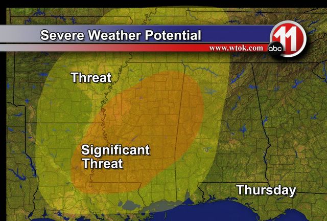
Our thinking hasn't changed much regarding the areas that should be most under the gun. In the "Significant Threat" area, there is the potential for large swaths of wind damage and large tornadoes.

New SPC Outlook
* The Storm Prediction Center has upgraded their Day 2 Outlook to a "Moderate" risk. The moderate risk includes all of our area and most of the state of Mississippi and the western half of Alabama. This is a fairly rare occurrence, and serves as evidence that they also believe there could be a significant severe weather event tomorrow.
* Here's the link:
SPC Day 2 Outlook* Will have a full update later this afternoon.
Thursday Severe Weather Threat
* We are continuing Instant Messaging conferencing with various weather entities across the Southeast this morning...Now would be a good time to provide an update in our thinking about exactly what may transpire tomorrow.
* An intense upper trough will swing through the lower Mississippi Valley tomorrow, bringing with it a deepening surface low. These two factors will come together with very impressive wind fields to spell a large threat of severe weather for our area.
* Threats: The main problem appears to be significant wind damage associated with bowing segments of a squall line. However, if individual storms can develop ahead of this squall line, there is the potential for significant tornadoes. Hail is a secondary concern.
* Timing: The squall line will likely affect our area between 2:00pm and 8:00pm. However, please keep in mind that should any storms develop ahead of this line, they would affect us earlier. So, the threat of severe weather is present anytime between 8:00 am and 8:00 pm tomorrow.
* Forecast Confidence: The confidence in a squall line developing and causing wind damage is rather high. But, the confidence in the tornado threat is a bit lower due to uncertainty about how much warming we can get. If the sun is out tomorrow, the confidence in the tornado threat will grow.
* What To Do: Tomorrow is a day to stay close to a good source of weather information. If you live in a mobile home, I recommend that you make arrangements to stay elsewhere during the day tomorrow if at all possible. Perhaps a relative or a friend's home would work well. Also, today or tonight would be a good time for you and your family to discuss your severe weather safety plan - all you need is a way to get warnings, and a safe place in your home (basement or lowest floor - interior bathroom, hallway, or closet).
* I will conduct an internal IM conference for our EMA partners today at 3:00 pm - if you are an EMA official and would like to participate, e-mail me at josh.johnson@wtok.com. I will post an updated version of our thoughts here later this afternoon.
Evening Update
* Just a few numbers for Meridian from the 0z NAM run (6pm)
Forecasted Severe Weather Indices for 6pm Thursday. All of these support severe weather.
- CAPE = 1032
- 0-3 KM SRH = 406
- EHI = 2.6
- LI = -3.8
- Total Totals = 50
- Wet Bulb Zero = 9972
* Our thinking has really not changed much at all. 0z NAM now has dewpoints getting up to around 64 and I tend to agree with Josh that the models will have a hard time picking up all of the moisture return/instability. Regardless, a severe weather event looks likely on Thursday
* A couple more interesting numbers that stick out from the 0z NAM
- Wind at 950 mb = 46 knts!
- Wind at 900 mb = 57 knts!
- Wind at 850 mb = 64 knts!
That is one strong low level jet!
* Now would be a good time to check the batteries in your NOAA weather radio and review your severe weather plan of action at home, work, and school!
* More updates to come later!
Quick Afternoon Update
* Please forgive the infrequent updates lately - I've had some major computer issues...
* We need to take some time to discuss the evolution of the severe weather threat for Thursday. The latest computer model guidance suggests that a potent upper trough will form and move through the central U.S. This trough will be accompanied by a deepening surface low, which will move from Arkansas towards the Ohio Valley. Historically, this is a favorable setup for a significant severe weather episode across our part of the world.
* There are several things that are enhancing the severe weather threat. We'll do a PLUS (+) and MINUS (-) breakdown of these factors. A PLUS+ is something that is enhancing the severe weather threat, while a MINUS- denotes a factor that is working against the severe threat. Of course, we are fans of the minuses. Here we go:
+ Approaching negatively tilted shortwave
+ Screaming 65-70 knot low level jet (measured at 850 millibars)+ Position of surface low and upper trough
+ Low level wind shear
- Upper level winds are unidirectional (from around 700 millibars to 200 millibars)
- Questions about availability of moisture-rich unstable air
* It should be noted that my opinion is that there will be sufficient moisture-rich air to support severe weather. But, our models are not overwhelmingly favorable in this department, so we'll leave it as an uncertain minus.
* We believe the main threat will be damaging winds within a squall line, but a significant threat of tornadoes will exist if supercells can develop ahead of the squall line.
* Timing: The worst of it here will occur between 8:00 am and 8:00 pm Thursday. We will narrow this time frame down later tonight and again tomorrow.
* Location: While the largest threat of tornadoes will come along and west of the MS/AL state line, there is the potential for tornadoes area-wide. And, almost all of us will have to deal with a very powerful squall line.
* Other opinions: Jeff Craven (a very bright severe weather researcher) over at the NWS in Jackson says that this event seems very favorable for a significant episode of severe thunderstorms and possibly tornadoes. He believes the worst threat will be along a corridor from Natchez to Laurel and possibly Meridian. We agree with most of these ideas.
* Bottom line: This is a good time for you, your family, your workplace, and your school to review their severe weather safety plan. Check the batteries in your weather radios and make sure they are working properly. If you don't have a weather radio, now is a good time to make a small investment that could save your life. They are available at any local consumer electronics store.
Thursday Threat
* First, the next couple of days look fantastic...Plenty of sunshine and warm temperatures headline our forecast for tomorrow and Wednesday. But, big changes arrive Thursday...
* Our computer model guidance suggests than an upper trough will swing through the south-central Plains, bringing a surface low through Missouri and into the Ohio Valley. Ahead of this system, strong southerly flow will bring in a warm and moist airmass. Exactly how much of this unstable airmass can move into our area remains unanswered, but we believe it will be enough to fuel some powerful thunderstorms.
* Here's our thinking on the evolution of things: A powerful squall line will form west of the Mississippi River early Thursday morning. Ahead of this line, there is some potential for discrete supercell thunderstorms to form. If that occurs, our tornado threat will be enhanced. Regardless, the line will race through Thursday afternoon, bringing a widespread threat of damaging winds to our area.
* The significant and most noticeable part of this setup is the screaming low-level jet. Model forecasts indicate that the winds around 5,000 feet above the ground could be on the order of 60-80 knots!! Wind shear looks ample - in fact, there may be TOO much wind shear. When shear gets too high, thunderstorms are often toppled by the powerful winds above the ground.
* The bottom line right now is that there is a lot of uncertainty regarding the evolution of this event. However, there is growing evidence to support a threat of a significant severe weather episode across the lower Mississippi Valley Thursday. Now is a good time to check the batteries in your NOAA Weather Radio. If you don't have a weather radio, they are available for purchase at many local consumer electronics stores.
* The rest of March looks active. As our good friend Alan Gerard (Meteorologist-In-Charge, NWS Jackson) noted at the Symposium this weekend, we have not had a significant outbreak of severe weather in March in a long time. Sure seems like we may be overdue.
Rain Tonight
* A squall line has developed in north Mississippi, moving south and southeastward tonight. Right now it extends roughly along the Highway 82 corridor from just north of the Golden Triangle westward through Winona, Greenwood, and Greenville.
* We expect this squall line to move through much of our area tonight, dropping a quick quarter inch of rainfall in localized areas. I'd imagine there is a good amount of lightning inside of the heavier cells as well!
* Skies will clear out tomorrow leaving us with a sunny and warm day as temperatures get into the lower 70s!
Quick Update
* Just checking out the 12z GFS and runs of the Canadian and European models. All show a powerful negatively tilted trough moving through. The Candian takes it through about a day ahead of the GFS and Euro -- Canadian on Weds, GFS and Euro on Thurs. Nevertheless, several medium range forecast models all picking up on this. Will be interesting to see how things play out!
* We'll see ample sunshine for the rest of the day with clouds building in by late afternoon. We won't rule out a few showers or a rumble of thunder tonight. At this time we'll throw in a chance of rainfall overnight.
* Will update again later this afternoon or evening!
Severe Weather Threat
* Good Sunday morning! What a beautiful start to the day with ample sunshine and cool but comfortable temperatures. It would be a perfect day for a round of golf but I think the plate will be too full to get a few swings in today...
* I'm starting to get very intrigued/concerned about severe weather on Thursday. As we always mention, past three days or so you start to wonder how the models will handle certain situations. But the fact that run after run of the GFS is showing the same feature over and over really increases confidence that something will happen. Through each run yesterday and this morning, the very strong shortwave trough has been further and further south. Each move southward increases our chances of a severe weather episode. I really get the idea that the Gulf will open up for several days in advance of the system, and the GFS is spitting out lows like candy. The one we are interested in is the Thursday time frame as the best upper level dynamics and surface low pass through. Yesterday I was thinking the Arkansas Delta and Mississippi Delta had the best threat, but watching the dynamics shift south has me concerned. I have noticed past events tend to bring dynamics south, before the closer runs bring it back north so we'll see what happens in future runs.
* Nonetheless, it looks like somewhere close to here will see a significant severe weather event. And as one presenter mentioned yesterday, the Deep South is long past due for a big time spring severe weather event and we are getting into that time of year again. Early indications (again, several days away) would suggest that a very strong squall line is possible with a few discrete supercells ahead of it. It is nearly impossible to speculate timing and pinpoint locations right now, but just know this is something we are keeping a watchful eye on and will begin to narrow things down throughout the week!