Wayne & Choctaw County Updates
* The tornado watch has been cancelled for Wayne County in Mississippi and Choctaw County in Alabama. Expect temperatures to cool rapidly this evening with strong northwesterly winds.
Tornado Watch Update
* A tornado watch remains in effect for Marengo, Clarke, and Choctaw counties in Alabama, as well as Wayne county in Mississippi. However, the line of showers and thundershowers that is currently moving through is not severe, and I suspect that the National Weather Service will drop the watch from those counties within the hour.
* With that said, a strong storm will move through Clarke county during the next 30-40min. This storm may produce some small hail (pea size), wind gusts to 35-40mph, and frequent lightning.
* This line of showers/thundershowers is along a cold front that has already moved through much of the area. After the front moves through, expect a 10-15 degree drop in temperatures within two hours!!! Winds will be from the northwest at 10-20mph, with gusts up to 30mph!
* It will be quite cool tonight!
New Tornado Watch Until 11:00 PM

* SPC has just issued a new Tornado Watch until 11:00 PM CDT mostly for the southeastern part of our viewing area.
In Mississippi: Wayne
In Alabama: Choctaw, Clarke and Marengo.
* Rob Hart will have more on Newscenter 11 at 6:00 PM...
Labels: Severe Weather
Strong Storm in Clarke County, MS
* A strong storm is affecting southern Clarke County in Mississippi. The storm is currently over De Soto, in the southern part of the county beween Quitman and Shubutta. Pea size hail may occur with this storm, and possibly some lightning, as it moves to the northest at about 45mph.
Clarke County, AL Storm Report
* There have been reports of trees and powerlines blown down about ten miles northwest of the City of Jackson in Clarke County, AL. Most of the damage is along Hwy 69 in Salitpa.
* The storm continues to remain over central Clarke County as it continues off to the east. It has weakened some, but hail, gusty winds, and frequent lightning are possible with this storm. Flooding may also become an issue as the storm continues to move over the same area.
Clarke County Update
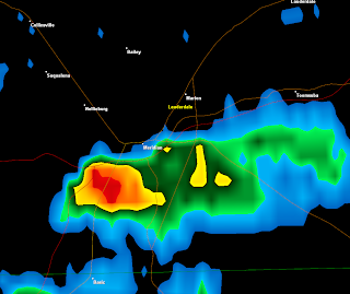
* A SEVERE THUNDERSTORM WARNING continues until 1:30 for central Clarke County in Alabama. The most dangerous part of the storm is currently over the City of Grove Hill. Scyrene, Dickinson, and Whatley are in the path of the most dangerous part of this storm.
* This storm is capable of producing golf ball size hail and winds up to 80mph!!! Some minor rotation is also occuring with this storm, but this is common with storms that produce large hail. No tornado has been detected at this time.
* This storm continues to move to the east at 45mph.
Jones County Tornado
* An EF-0 tornado (top winds 65-85mph) occurred at about 10:35 this morning in Jones County. The tornado briefly touched down about nine miles west of Ellisville . No damage has been found with this tornado.
* Jones County is quite lucky as the velocity signatures on the radars were indicating the possibility of a large and damaging tornado!
Forrest County Update
* Extensive damage has been reported about eight miles east/southeast of Hattiesburg in Forrest County. Significant damage has been reported near the Sunrise Community, and one house has been deemed "uninhabitable" from the damage. In addition, numerous trees and powerlines are down.
* National Weather Service assessment teams will go to the area to decide whether strong winds or a tornado caused the damage.
* Flooding has also been reported on the west side of Hattiesburg where five houses on Bridges Circle were flooded.
Severe Thunderstorm Warning: Clarke County, AL
*Large hail possibly affecting the City of Jackson at this time!!!
* A SEVERE THUNDERSTORM WARNING has been issued for central Clarke County in Alabama, until 1:30pm. A large severe thunderstorm is moving out of Washington County into Clarke. While a tornado warning was issued for Washington County, the storm has lost it's rotation, but remains severe. The City of Grove Hill, as well as the communities of Winn, Allen, Whately, Dickinson, Scyrene, and Nettleboro all may experience severe weather.
This storm is what we call a "right-mover". The storm is moving to the "right" of the general movement of the surrounding storms. That is a red-flag to meteorologists that the storm is strong and is capabale of producing severe weather.
Hail to the size of nickels, and winds of 60-65mph are possible with this storm.
* Text:
http://kamala.cod.edu/ms/latest.wuus54.KMOB.html
Alabama Update
* The tornado warning for Choctaw County has been allowed to expire. The storm while still strong, has weakened. No reports of damage have been received at this time. Residents in Sumter, Greene, and Marengo counties may experience some small hail, wind gusts from 40-50mph, and very heavy rain as the storm continues to weaken and move through the area.
Damage from Forrest County.
* Significant damage has been reported to the Sunrise area in Forrest County. That's near Hattiesburg. That area had two significant supercells move through the area earlier this morning, and it is possible that the damage is from a tornado. We'll post more information as it becomes available.
Winston County Update
* The severe thunderstorm warning for Winston County has been cancelled. The storm has moved out of the area and has also weakened. However, the storm still remains strong as it has moved into northern Noxubee County. The town of Brooksville may experience some small hail, and perhaps a strong wind gust or two of up to 50mph.
* No reports of hail have been received at this time.
Severe Thunderstorm Warning: Winston County
* A SEVERE THUNDERSTORM WARNING has been issued for Winston County until 12:30 this afternoon. The main threat with this storm will be hail to the size of pennies, and possible winds gusting up to 60mph. Folks in southern and eastern parts of Winston County have the highest risk of seeing severe weather.
This storm could clip Louisville.
* Text:
http://kamala.cod.edu/ms/latest.wuus54.KJAN.html
Update
The National Weather Service is going to let the tornado warning for Clarke County in Mississippi expire at 11:45. This is the storm that is moving into Choctaw County.
No reports of damage have been received in Clarke County, at this time. However, a tornado is still possible as rotation is being detected on radar.
If you have any storm reports, email them to us at
rob.hart@wtok.com and
chris.whited@wtok.com
Tornado Warning: Choctaw County
* A TORNADO WARNING has been issued for Choctaw County in Alabama until 12:15 this afternoon. A supercell thunderstorm is moving into the county and may contain a tornado. The City of Butler is in the path of this possible tornado.
In addition to this storm, large damaging hail (possible up to the size of quarters), strong winds up to 55-60mph, and frequent cloud-to-ground lightning are possible with this storm.
* Text:
http://kamala.cod.edu/ms/latest.wfus54.KMOB.html
Clarke County Update
* TORNADO WARNING continues until 11:45 for eastern Clarke County in Mississippi. The possible tornadic area passed near Quitman within the past ten minutes. This storm will affect mainly eastern parts of Clarke County.
Tornado Warning: Wayne County
* A TORNADO WARNING has been issued for southern Wayne County in Mississippi until 12Noon. A strong supercell thunderstorm will affect Greene, Perry, and southern Wayne counties. This storm is capable of producing a tornado.
In addition to this storm, people in Wayne County may experience large hail, strong winds up to 55-60mph, frequent lightning, and very heavy rains.
* Text:
http://kamala.cod.edu/ms/latest.wfus54.KMOB.html
Clarke & Jasper Counties Update
* The TORNADO WARNING for Jasper County has been cancelled, as the storm has moved into Clarke County.
The warning remains in effect until 11:45 for Clarke County. Desoto & Goodwater are in the path of this possible tornado, as the storm moves off to the northeast at about 50mph. In addition to this storm, expect large damaging hail, strong winds up to 60mph, and frequent lightning.
New Tornado Warning: Jones County
* A new TORNADO WARNING has been issuesd for southeastern Jones County until 11:30 this morning. A new tornadic storm is affecting the southern part of the county. This new storm produced damage in the Hattiesburg area earlier. This storm is moving northeast at 55mph. Like the previous storm (which is now affecting Clarke and Jasper counties), it may be producing a large and damaging tornado.
* Text:
http://kamala.cod.edu/ms/latest.wfus54.KJAN.html
Tornado Warning: Jasper & Clarke Counties
* TORNADO WARNINGS have been extended into far southeastern Jasper county and Clarke county. This is the storm that produced a possibly significant tornado earlier this morning in Jones county. Although the rotation on this storm is not as strong as what it was in Jones County, a tornado is still possible!
Goodwater, Desoto, Quitman, and the Clarke County State Park are all in the path of this possible tornado.
In addition to this storm, large damaging hail and frequent lightning are possible!
* Text:
http://kamala.cod.edu/ms/latest.wfus54.KJAN.html
Severe Thunderstorm Warning: Clarke & Jasper Counties
* The National Weather Service has issued a SEVERE THUNDERSTORM WARNING for Clarke & Jasper counties until 11:45 this morning.
This warning has been issued for the northern part of the tornadic storm that is currently affecting Jones county. The main threat at this time is for hail up to the size of nickels. People in Jasper and Clarke counties should be on the lookout for a possible upgrade to a tornado warning within the next 15 minutes.
This may quickly become a volatile situation in eastern Jasper and Clarke counties!
* Text:
http://kamala.cod.edu/ms/latest.wuus54.KJAN.html
Tornado Warning: Jones County - Dangerous Situation
* A TORNADO WARNING has been issued for Jones County unti l11:15 this morning.
* This is an extremely DANGEROUS and LIFE-THREATENING situation!!! This storm may be producing a large damaging tornado, capable of producing significant damage! A tornado has been reported on the ground 9 miles west of Ellisville at 10:35am!
* Laurel is in the most dangerous part of the storm at this time!
* Text:
http://kamala.cod.edu/ms/latest.wfus54.KJAN.html
Tornado Watch Issued
* A TORNADO WATCH has been issued for parts of the Newscenter 11 viewing area. The counties under the watch in Alabama are: Clarke, Wayne, Choctaw, Marengo, Sumter, Greene, Hale counties, and Clarke, Wayne, and Jones counties in Mississippi. This watch goes until 6pm this evening.
* Supercells are developing across southern Mississippi and will begin to affect southern and eastern parts of the viewing area during the late morning and early afternoon hours.
* Chris and I are in the weather center and will have updates as needed.
* Folks in the tornado watch need to be very careful today as this could become a significant tornado event late this morning.
* Text:
http://weather.cod.edu/kamala/offs/KWNS/0704141525.wwus20.html
Severe Thunderstorm Warning: Leake County
* A SEVERE THUNDERSTORM WARNING has been issued for Leake County until 10:45 this morning. This includes the City of Carthage. This storm is moving northeast at about 55mph. The main threat with this storm is hail to the size of nickels, and possibly some isolated wind gusts up to 60mph.
* Text:
http://kamala.cod.edu/ms/latest.wuus54.KJAN.html
Tornado Warning: Jones County
* A TORNADO WARNING has been issued for Jones County in Mississippi until 10:45 this morning. The most dangerous pats of the storm will be near Hebron, Moss, and Sandersville. This is a very dangerous storm. The rotation on this storm is significant and a tornado forming is very possible.
* People in Jasper and Clarke counties should keep an eye on this storm as it moves through the area.
* Text:
http://kamala.cod.edu/ms/latest.wfus54.KJAN.html
10:00 Weather Update:

(Click for Larger View)
* Current radar shows a band of strong thunderstorms over Hind and Rankin County with embedded strong storms over Leake, Neshoba, and Scott. Light to moderate rain across Clarke and moving into Lauderdale County.
* Tornado warnings to our southwest for Covington and Marion counties...
* Severe Thunderstorm Watch until 1:00 PM....
* A reminder our weather cut-ins are being simulcast on WMOX-AM 1010 here in Meridian.
* More updates throughout the morning from Rob and I here on the blog...
Labels: Forecast Discussion
Leake County Update
* The Severe Thunderstorm Warning for Leake County has been cancelled. The storm is still strong and may be producing some small hail, but is below severe limits at this time.
Severe Thunderstorm Warning: Leake County
* A SEVERE THUNDERSTORM WARNING has been issued for Leake County until 9:30 this morning. The main threat will be large hail and winds up to about 60mph. Carthage is in the path of this storm, possibly seeing the storm around 8:55, as well as Edinburg by around 9:10am.
* Warning text:
http://kamala.cod.edu/offs/KJAN/0704141352.wuus54.html
Quick Note About Weather Coverage:
* We don't recommend you be out and about today with the severe weather threat but some of you have to go to work or have to run errands so just a reminder you can hear our severe weather updates on the radio in East Mississippi and West Alabama on WMOX-AM 1010. Their signal covers nearly all of WTOK's television viewing area.
Labels: Public Information Statements
Winston County Warning Cancelled
* The severe thunderstorm warning for Winston County has been cancelled. The storm that was affecting the area has weakened below severe levels.
* No damage reports have been received at this time. If you have any storm or damage reports, please email them to
rob.hart@wtok.com &
chris.whited@wtok.com .
Severe T-Storm Warning - Winston Co.
* The NWS in Jackson has issued a Severe Thunderstorm Warning for Winston Co. until 8:45 AM.
Warning text:
http://kamala.cod.edu/offs/KJAN/0704141303.wuus54.htmlThe storm will move though Choctaw County and move into Winston County. The storm will affect High Point and Louisville.
Labels: Severe Weather
Tornado Warning - Leake Co.
* The NWS in Jackson has issued a Tornado Warning until 8:30 AM for Leake Co.
Warning text:
http://kamala.cod.edu/offs/KJAN/0704141238.wfus54.htmlThe storm will affect the Northwest corner of the county... places like Thomastown and Farmhaven.
Labels: Severe Weather
Severe T-Storm Watch Until 1:00 PM

* The SPC has issued a Severe Thunderstorm Watch For Eastern Mississippi until 1:00 PM.
* In our area the watch includes: Winston, Noxubee, Leake, Neshoba, Kemper, Scott, Newton, Lauderdale, Smith, Jasper, Clarke, and Jones County
Labels: Severe Weather
5:00 AM Report:


* Line of strong thunderstorms across Central Louisiana will sweep into Southern Mississippi later this morning and will affect our area later on into the day. There are thunderstorms across Central Mississippi but there have been little, if any warnings...so far.
* Tornado Watch for Central Louisiana and far Western Mississippi in effect until 8:00 AM. I feel a watch will be issued for our area and at least for our Mississippi counties here in the next few hours. Of course once we get past sunrise and start adding daytime heating into the mix things will probably go downhill.
* SPC outlook still the same as the last three runs with a Moderate Risk from Hattiesburg to Meridian to Demopolis and points southward with a slight risk over the northern part of the viewing area.
* Rob and I will have more as we go into the morning here on the weather blog and on Newscenter 11.
Labels: Forecast Discussion and Severe Weather
Midnight Weather Report:

(Click for larger view)
* Strong to severe thunderstorms continue across East Texas and Northern Louisiana this Saturday morning and will work their way eastward overnight. This activity will affect us later this morning and afternoon.
* A warm front will work its way through Mississippi overnight and once we get south of the front, we will be in an unstable air mass which could allow isolated severe storms to develop this morning ahead of the main line of severe storms which should arrive around midday or early afternoon.
* Rob and I will have more updates throughout the morning and team coverage of the severe weather on television.
Labels: Forecast Discussion
Storm Reports From Texas
* Here are some of the more significant storm reports from Texas:
* 7omph winds in Arlington
* 3.00" hail (teacup size) in Colleyville (a suburb of Ft. Worth)
* 2.75" hail (baseball size) at the National Weather Service Office in Ft. Worth
* 2.50" hail (tennis ball size) at DFW Airport
* Amarillo, TX had severe thunderstorms this morning. Now it's snowing there!
Weather Watches Going Up To Our West:


* A PDS Tornado Watch has been issued for most of Northern Louisiana and extreme Southern Arkansas until 2:00 AM. A Severe Thunderstorm Watch has been issued for Arkansas and Northwest and Delta of Mississippi until 2:00 AM.
* As you can see from the radar images strong thunderstorms are forming ahead of the main band of severe weather across North Texas. I'm concerned that we may see some severe weather here in our area toward the early morning hours before or just after sunrise with isolated activity. The main cold front/line of severe thunderstorms with this system over Northern Texas will sweep into East Mississippi and West Alabama by early afternoon.
* More on the blog here tonight and more on Newscenter 11 at 10:00..
Labels: Forecast Discussion and Severe Weather
Detailed Severe Weather Forecast:


* An active severe weather day setting for tomorrow across the Twin States as a powerful storm system now over Texas makes its way east toward our area.
* Here is the rundown... The main severe weather complex is sitting over the Dallas-Fort Worth Metroplex in Texas. However, there are isolated severe storms popping over Northern Louisiana and Southern Arkansas. I think we are going to see isolated severe storms during the morning hours here in East Mississippi and West Alabama with the main event coming in the form of a strong squall line in the early and mid-afternoon hours.
* A moderate risk of severe weather is in place from Hattiesburg to Meridian to Demoplolis and for the areas south of that line. Areas north of US 80 are under a slight risk for severe weather.
* I should mention there is the threat of locally heavy rain with this system that could cause some flooding in spots. I know we are still in our drought but if we see constant heavy rain over the same areas, some flooding can be possible.
* We'll have more on Newscenter 11 at 6:00 and 10:00. Rob Hart and I will continue to update the blog throughout the night and tomorrow. We'll have team coverage during the day tomorrow.
Labels: Forecast Discussion and Severe Weather
High Risk in Texas

* High risk of severe weather today and tonight in Texas!
* A high risk has been issued for parts of Texas. Large, damaging, long-track tornadoes are possible this evening and tonight off to our west. The last time a high risk was issued in the nation was March 1, when the southeast had a tornado outbreak. Hopefully things won't get that bad in Texas, but conditions are favorable for a tornado outbreak.
*We remain under a risk of severe weather for tomorrow. Chris will have full details coming up in his weathercasts at 5 and 6.
Severe Weather Threat Update:

* Day 2 SPC Outlook has not changed much since this morning. SPC still maintains a Moderate Risk roughly along I-59 from Hattiesburg to Meridian and along US 80 from Meridian to Demopolis to Montgomery and all points south of that line. The rest of our area North of US 80 is under a slight risk.
* Jackson NWS Hazardous Weather Outlook:
...THUNDERSTORMS...
A SEVERE WEATHER OUTBREAK WILL BE POSSIBLE LATE TONIGHT AND SATURDAY AS A MAJOR STORM SYSTEM MOVES EAST ACROSS THE LOWER MISSISSIPPI RIVER VALLEY. THE COMBINATION OF STRONG WIND SHEAR AND INSTABILITY...AND THE PASSAGE OF A STRONG LOW PRESSURE SYSTEM...WILL RESULT IN SEVERE THUNDERSTORMS AFFECTING WESTERNPORTIONS OF THE OUTLOOK AREA LATE TONIGHT...WITH SEVERE STORMS EVENTUALLY SPREADING EASTWARD INTO EASTERN MISSISSIPPI SATURDAY.
SEVERE THUNDERSTORMS ARE EXPECTED TO DEVELOP INITIALLY OVER SOUTHEAST ARKANSAS AND NORTHEAST LOUISIANA LATE TONIGHT...AND THEN INCREASE IN COVERAGE AFTER MIDNIGHT AS THEY MOVE INTO WESTERN MISSISSIPPI AND BECOME MORE ORGANIZED. THE LEADING EDGEOF A COMPLEX OF THUNDERSTORMS IS EXPECTED TO REACH THE NATCHEZ TRACE CORRIDOR AFTER SUNRISE SATURDAY MORNING. FROMTHERE...THUNDERSTORMS WILL CONTINUE TO SHIFT EAST ACROSS CENTRAL MISSISSIPPI AND INTO EAST AND SOUTHEAST MISSISSIPPI LATE SATURDAY INTO SATURDAY AFTERNOON WHILE CONTINUING TO PRODUCE SEVERE WEATHER.
WHILE LARGE HAIL...DAMAGING WINDS...AND ISOLATED TORNADOES WILLBE POSSIBLE OVER MUCH OF THE OUTLOOK AREA DURING THIS TIME...THEGREATEST RISK FOR TORNADOES WILL BE OVER AREAS LOCATED ALONG ANDSOUTH OF A JONESVILLE LOUISIANA TO VICKSBURG MISSISSIPPI TOCANTON TO DE KALB LINE WHERE THE MOST UNSTABLE AIR IS EXPECTED
....FLOODING...
HEAVY RAINFALL WILL ALSO BE A CONCERN OVER MUCH OF THE OUTLOOKAREA LATE TONIGHT INTO SATURDAY AS THUNDERSTORMS DEVELOP ANDINCREASE IN COVERAGE...AND LATER ORGANIZE INTO A COMPLEX. RAINFALL AMOUNTS OF ONE TO TWO INCHES WILL BE POSSIBLE OVER MUCHOF THE AREA. HOWEVER...AS THE COMPLEX MOVES INTO EAST ANDSOUTHEAST MISSISSIPPI LATE SATURDAY MORNING INTO SATURDAYAFTERNOON WHERE THE GREATEST AMOUNT OF INSTABILITY WILL EXIST ANDSLOWS...THUNDERSTORMS COULD EASILY BEGIN TO PRODUCE RAINFALLAMOUNTS OF TWO TO THREE INCHES OVER THESE AREAS. LOCALLY HIGHERAMOUNTS COULD BECOME POSSIBLE DURING THIS TIME IF STORMS BEGIN TOMOVE OVER THE SAME AREA.
* I just got into the station here so once I get a look at the models and get my forecast package put together, I'll give a more detailed synopsis of the storm event. More of course on Newscenter 11 at 5:00 and 6:00...
Labels: Forecast Discussion
Severe Weather Tomorrow:

* As I mentioned earlier areas north of US 80 in East Mississippi and West Alabama are under a sligt risk for tomorrow while areas south of US 80 and east of I-59 are under a moderate risk of severe weather for tomorrow.
* A warm front will work its way up through the Twin States as we go through the day today and will put the area under warm and unstable air for the tonight and tomorrow. My thought is (which will likely change as newer data comes in later today) that we will see two rounds of severe weather tomorrow. The first round will come early in the morning with isolated supercells and bow segments moving through the area. As we get later into the day and the front moves closer, a second round (probably a squall line or a mesoscale convective complex) will move into the area. The 6Z GFS run seems to nail my ideas with a decent mass of rain and thunderstorms entering our western viewing area around 12Z (1:00 PM CDT). The 6Z NAM model is showing the scattered activity during the morning hours as well as the afternoon event.
* I'll have more on the threat on Good Morning Meridian at 6:00 AM. I'll update this afternoon here on the blog after new data comes in and I'll have a more detailed forecast of the threat tonight on the evening newscasts.
Labels: Forecast Discussion
Moderate Risk For Severe Weather Saturday


* Good morning... I'm usually in bed right now but since I am fighting insomnia and awake I noticed the new Day 2 Outlook from the SPC is out and is still painting an active Saturday for severe weather for the Twin States.
* All of our viewing are is under a slight risk area of severe weather but a moderate risk is in place for the southern part of our viewing area. The moderate risk area runs roughly Along Interstate 59 from Hattiesburg to Meridian to Tuscaloosa to Birmingham and points south and southeast of that line.
* Notes from the SPC Outlook:
AT THE SURFACE...A WEAK LOW IS INITIALLY FORECAST OVER
THE MS DELTA REGION...WITH A COLD FRONT EXTENDING SWWD
INTO SERN TX.  THE LOW IS FORECAST TO DEEPEN SLOWLY WITH
TIME...WHILE IT AND THE ASSOCIATED COLD FRONT MOVE EWD
ACROSS THE SOUTHEAST THROUGH THE FIRST HALF OF THE PERIOD.
DURING THE SECOND HALF OF THE PERIOD...THIS LOW IS FORECAST
TO DEEPEN MORE RAPIDLY...WHILE MOVING NEWD ACROSS THE
ATLANTIC COAST STATES TO VA BY THE END OF THE PERIOD.

...THE SOUTHEAST...
STRONG TO SEVERE THUNDERSTORMS ARE FORECAST TO BE ONGOING
ALONG/AHEAD OF COLD FRONT AT THE START OF THE PERIOD...FROM
WRN MS SWWD TO SWRN LA.  MEANWHILE...BROAD REGION OF SLY
SURFACE WIND IS FORECAST TO BE ADVECTING RICH BOUNDARY-LAYER
MOISTURE NWD OFF THE GULF INTO THE GULF COAST STATES.  THOUGH
WEAK LAPSE RATES SHOULD LIMIT THE OVERALL POTENTIAL FOR WARM
SECTOR DESTABILIZATION...MID 60S TO LOW 70S DEWPOINTS SPREADING
ACROSS THE SRN HALVES OF THE GULF COAST STATES BY MIDDAY COMBINED
WITH DAYTIME HEATING SHOULD RESULT IN 500 TO 1000 J/KG MEAN-LAYER
CAPE BY MIDDAY/EARLY AFTERNOON.

STORMS SHOULD INTENSIFY WITHIN THE LINEAR COMPLEX ALONG/AHEAD
OF COLD FRONT THROUGH MIDDAY...WHILE A FEW ISOLATED STORMS
MAY DEVELOP  AHEAD OF THE MAIN CONVECTIVE LINE NEAR SUBTLE
LOW-LEVEL BOUNDARIES POSSIBLY ASSOCIATED WITH WEAK LEAD
MID-LEVEL FEATURE.

THOUGH MAIN UPPER TROUGH AND ASSOCIATED COOLING ALOFT SHOULD
REMAIN WELL TO THE W OF THE SURFACE FRONT...STRONG SWLY
LOW-LEVEL WIND FIELD BENEATH DIFFLUENT 60 TO 70 KT SWLY
MID-LEVEL FLOW ACROSS THE WARM SECTOR WILL RESULT IN SHEAR
FAVORABLE FOR ORGANIZED/SUPERCELL STORMS. WHILE IT APPEARS
THAT FLOW FROM ROUGHLY 850 MB AND ABOVE WILL BE ROUGHLY
UNIDIRECTIONAL...SLY SURFACE WINDS VEERING TO SWLY AT 850 MB
SHOULD YIELD SUFFICIENT SHEAR FOR LOW-LEVEL UPDRAFT ROTATION.
THIS COMBINED WITH MOIST BOUNDARY LAYER -- PARTICULARLY WITH
SWD EXTENT TOWARD THE GULF COAST -- AS WELL AS THE OVERALL
INTENSITY OF THIS SYSTEM SUGGEST THAT SEVERAL TORNADOES WILL
BE POSSIBLE.
* I'll have more on the threat later this morning on Good Morning Meridian as well as on the blog this afternoon and tonight on Newscenter 11 at 5:00, 6:00, and 10:00
Labels: Forecast Discussion
Severe Weather Threat Saturday


* Severe weather will be possible across the Twin States during the day on Saturday as a powerful storm system moves our way.
Here is the latest Hazardous Weather Outlook from the NWS Jackson:
.DAYS TWO THROUGH SEVEN...FRIDAY NIGHT THROUGH
THURSDAY...

...DAYS TWO AND THREE...FRIDAY NIGHT THROUGH
SUNDAY NIGHT...

A SEVERE WEATHER OUTBREAK WILL BE POSSIBLE FROM
FRIDAY NIGHT INTO SATURDAY AS A MAJOR STORM SYSTEM
MOVES EAST ACROSS THE LOWER MISSISSIPPI RIVER VALLEY.
THE COMBINATION OF STRONG INSTABILITY AND WIND SHEAR
...AND THE PASSAGE OF A STRONG LOW PRESSURE SYSTEM...
WILL RESULT IN SEVERE THUNDERSTORMS ACROSS THE ENTIRE
OUTLOOK AREA.
ISOLATED SEVERE THUNDERSTORMS WILL BE POSSIBLE FRIDAY
NIGHT OVER PORTIONS OF NORTHEAST LOUISIANA AND SOUTHEAST
ARKANSAS...AS A WARM FRONT LIFTS NORTH ACROSS THE AREA.
RICH GULF MOISTURE WILL SURGE NORTHWARD SOUTH OF THE WARM
FRONTAL BOUNDARY ACROSS LOUISIANA... HELPING TO CREATE A
VERY UNSTABLE ENVIRONMENT. WITH STRONG WINDS ALOFT...ANY
STORMS THAT DEVELOP NEAR THE WARM FRONT WILL HAVE THE
POTENTIAL TO BECOME SUPERCELLS CAPABLE OF PRODUCING
SEVERE WEATHER.

THUNDERSTORM COVERAGE WILL INCREASE FURTHER EAST THROUGH
THE EARLY MORNING HOURS SATURDAY ALONG WITH THE RISK OF
SEVERE WEATHER...ESPECIALLY IN AREAS ALONG AND SOUTH OF
INTERSTATE 20 WHERE THE GREATEST RISK FOR LARGE HAIL...
DAMAGING WINDS...AND ISOLATED TORNADOES WILL EXIST. STRONG
TO SEVERE THUNDERSTORMS ARE EXPECTED TO ORGANIZE INTO A
LARGE THUNDERSTORM COMPLEX...WHICH WILL WORK ITS WAY SLOWLY
EAST ACROSS THE OUTLOOK AREA SATURDAY.

IN ADDITION TO THE SEVERE WEATHER...HEAVY RAINFALL COULD
BE A PROBLEM OVER THE ENTIRE OUTLOOK AREA AS THUNDERSTORMS
ARE EXPECTED TO BRING TWO TO THREE INCHES OF RAINFALL IN
JUST A FEW HOURS.
Labels: Forecast Discussion
Severe Weather Winding Down:
* The severe weather is moving out of our area as the cold front makes its way into East Mississippi and West Alabama. The tornado watch has been cleared for all of East Mississippi and is slowly being shaved away in West Alabama
* Severe Thunderstorm Warning for Clarke Co. Alabama until 4:15 for a severe storm over the northern part of the county.
* A cool night is in store with lows in the lower 40s with in the area.
* More on your local forecast at 5:00
Labels: Forecast Discussion
Tornado Warning - Marengo and Hale Co. Severe Thunderstorm Warning - Choctaw Co. Tornado Watch Cancelled for East Mississippi
* NWS Birmingham has issued a Tornado Warning for Northeastern Marengo County until 3:45 and a Tornado Warning for Hale County until 3:45. Storm will affect far Northeastern Marengo Co. and Southern Hale Co.
* NWS Mobile has issued a Severe Thunderstorm Warning for Choctaw Co. until 3:45. The severe thunderstorm will affect Womack Hill, Butler and the South Central part of the county.
* NWS Jackson has cleared all East Mississippi counties from the Tornado Watch. It is still in effect for West Alabama until 8:00 PM.
Labels: Severe Weather
T-Storm Warning - Sumter, Green, Hale
* NWS Birmingham has issued a Severe Thunderstorm Warning for Green, Sumter, Hale and Marengo Co. in West Alabama until 3:15 PM.
Warning text:
http://kamala.cod.edu/offs/KBMX/0704111930.wuus54.htmlStrong to severe thunderstorms are occuring over the warned counties. The storm over Sumter Co. is showing some weak rotation.
Labels: Severe Weather
Severe T-Storm Warning - Clarke County, Miss.
* The NWS in Jackson has issued a Severe Thunderstorm Warning for Clarke Co. in Eastern Mississippi until 3:00 PM.
Warning text:
http://kamala.cod.edu/offs/KJAN/0704111919.wuus54.htmlThe storm will affect De Soto, Goodwater, and Crandall.... it is moving eastward at 40 mph
Labels: Severe Weather
Severe T-Storm Warning - Sumter, Greene, Hale Co.
* The NWS has issued a Severe Thunderstorm Warning warning until 2:30PM for Sumter, Green and Hale Co.
Warning text:
http://kamala.cod.edu/offs/KBMX/0704111900.wuus54.htmlThe storms will affect Epes, Forkland, Eutaw, Clinton, and Moundville
Labels: Severe Weather
Tornado Watch Until 8:00 PM

* The SPC has issued at Tornado Watch until 8:00 PM until for Clarke, Jasper, Lauderdale, Newton, Kemper, Neshoba, Noxubee, Winston in Eastern Mississippi and Green, Sumter, Marengo in West Alabama
Labels: Severe Weather
Thunderstorms Over Lauderdale & Kemper Co.

Kemper Co. (Click to enlarge)
Lauderdale Co. (Click to enlarge)
* Strong thunderstorms are affecting Lauderdale and Kemper counties at the moment. Heavy rain is falling in Meridian and DeKalb. These storms are not severe at the moment but may contain some small hail and gusty winds.
Labels: Radar Update
Radar Update - Watch Possible Soon

(12:37 PM Radar - Click for larger view)
* Thunderstorms are increasing in coverage across Eastern Mississippi this Midday ahead of a strong cold front that will sweep into the area later this afternoon and evening.
* The SPC has indicated in a mesoscale discussion that a weather watch will probably be issued here in the next hour or two for Eastern Mississippi and Western Alabama. The primary threat is large hail and damaging winds.
* Stay with me here on the blog for updates and of course on Newscenter 11 if we start seeing warnings issued for our area.
Labels: Forecast Discussion
11:00 AM Update


(11:00 AM Radar and Visible Satellite - Click for larger view)
* A band of showers and thunderstorms is moving across Noxubee and the very northern part of Kemper County. This band of showers and storms is moving eastward and will move into West Alabama in the next hour.
* Radar and satellite also shows a band of thunderstorms developing over far Northern and Western Mississippi as well as Northern Louisiana along and ahead of the cold front. The front will move into the area by mid-afternoon and could still bring some strong to severe thunderstorms to East Mississippi and West Alabama. SPC still maintains a slight risk area for Eastern Mississippi and Western Alabama today.
* More updates as we go into the afternoon...
Labels: Forecast Discussion
Morning Update:


(Current Radar Image and Visible Satellitle Image at blog update time)
(Click for a larger view)
* Clouds are holding tough this morning as we are still seeing scattered showers and a few isolated storms to the west of the WTOK viewing area this morning. Also be advised with the temperature and dewpoint close together this morning in the lower 60s we are seeing quiet a bit of fog across the area. You can also see thunderstorms developing along the I-55 corridor on radar and on the visible satellite image.
* SPC has canceled the Severe T-Storm Watch that was in effect for Central Mississippi. The severe weather threat at the moment is low, but we'll see a better chance later today across the area.
* Still seeing the warm front on the surface data slowly creeping up to into the area. As the warm front moves through it will put our area in unstable and moist air. A cold front moving through the Ark-La-Tex will make its way toward Mississippi and Alabama later today and will help kick off strong thunderstorms in the unstable air. I still think the primary threats are for large hail and damaging winds. The SPC still maintains a slight risk of severe weather from roughly MS Hwy 15 in East Mississippi eastward into most of Central Alabama.
* I'll keep an eye on the weather situation here at home and will head back to the station if things start going downhill later this morning and early afternoon. Otherwise, I'll keep updating the weather blog and have more on the forecast tonight at 5:00 and 6:00 on Newscenter 11.
Labels: Forecast Discussion
Showers Developing To Our West:

(7:20 AM Radar - Click for larger version)
* Showers and thunderstorms are beginning to develop cross Central Mississippi mainly north of the Jackson Metro Area.
* The warm front will lift into our area later this morning and will bring strong storms later today. A slight risk of severe weather is set for our area today.
Labels: Forecast Discussion
6:50 AM Update:

* A broken band of showers and storms is running roughly from about Iuka to about Greenwood and addition showers around Yazoo City and over to about Mayersville. Also take note of the band of showers back in the Northwest Louisiana area. That band of showers is the cold front.
* The Severe Thunderstorm Watch has been canceled for the area from about I-20 and north to about a Kosciusko to Lexington to Belzoni and points north.
* We are still expecting strong storms to develop later this morning and some could be severe later today.
Labels: Forecast Discussion
5:15 AM Update:


(5:15 AM Radar Images - Click for larger views)
* Have noticed that there have been no warnings in the last 2 hours for the storms over Northwestern Mississippi. Strong thunderstorms continue in a line through Panola, Quitman, Tallahatchie, Sunflower and Bolivar Counties this morning with the main complex moving across that part of the state.
* Our severe weather threat will come from a warm front running roughly along US 84 as it moves northward today putting us in unstable air and the cold front off to our west sweeping into the area later today. Already the radar images above show new storms developing over Northern Louisiana and Southern Arkansas. Several shortwave low pressures along the warm front will help storms pop as we go through the day. The main threat today is large hail and damaging winds. All of our area here in East Mississippi and Western Alabama is under a slight risk from the SPC.
* More weather on Good Morning Meridian at 6:00 AM. I will blog some more after the morning news and our GMA weather updates... of course sooner if needed.
Labels: Severe Weather
4:30 AM Update


(4:30 Radar Images - Click for larger views)
* Severe Thunderstorm Watch in effect just west of our coverage area until 10:00 AM. At the moment no counties in WTOK's viewing area are included in the watch.
* The line of showers and thunderstorms now across the Delta in Western Mississippi moving eastward. Addition storms are expected to form along the cold front and outflow boundaries as we go through the day that could become severe and affect East Mississippi and West Alabama.
* I'll have more on the storm threat today coming up later this morning on Good Morning Meridian at 6:00 AM!
Labels: Severe Weather
New Severe T-Storm Watch To Our West:


* The SPC has just placed counties to the west of our viewing area under a Severe Thunderstorm Watch until 10:00 AM for that nasty line of storms moving into the Delta region in Eastern Arkansas and into Western Mississippi.
* This line of storms has been slowly building and moving off the the east and southeast and will affect our area later today.

* The new SPC Day 1 outlook is out and now places all of our area under a slight risk of severe weather for today. The primary threat would be hail and damaging winds.
* I'll watch the weather situation and have more on Good Morning Meridian at 6:00 AM.
Labels: Severe Weather
Lauderdale County SKYWARN Class:
* Passing along this note from David Sharp with the Lauderdale County Emergency Management Agency:
NWS Jackson SKYWARN Class
Meridian- Lauderdale Co.
Monday, April 23rd
7:00 PM
LEMA Building (the building across the street from the central fire station on the hill)
FMI: 601-482-9852
Labels: Public Information Statements
Rain Chances Remain:

(4:00 PM Radar - Click for larger view)

* Good afternoon everyone. I noticed this afternoon that my access to the blog server at work is no longer locked out (for now) so I thought I would drop a blog entry here for everyone.
* Good mass of rain and embedded thunderstorms continues across East Mississippi and West Alabama and will continue to move eastward this afternoon and evening. Another round of rain and storms will come back later tonight and during the day tomorrow.
* We sit in a zonal pattern (west to east flow) here across the Southeast and this allows these shortwave impulses to move across the Twin States and bring rain and thunderstorms. A strong trough and cold front will affect the area late Friday night and Saturday morning. We'll have to watch for the possibility of severe weather during that time period but early looks seem to favor the more organized severe weather event off to our west across the Delta.
* The radar on wtok.com/weather is not updating again. This is on the radar software providers end and not ours. So for a radar check please link to the following:
Jackson NWS Radar:
http://radar.weather.gov/radar_lite.php?rid=dgx&product=N0R&loop=noBirmingham NWS Radar:
http://radar.weather.gov/radar_lite.php?rid=bmx&product=N0R&loop=noMobile NWS Radar:
http://radar.weather.gov/radar_lite.php?rid=mob&product=N0R&loop=no
Labels: Forecast Discussion


