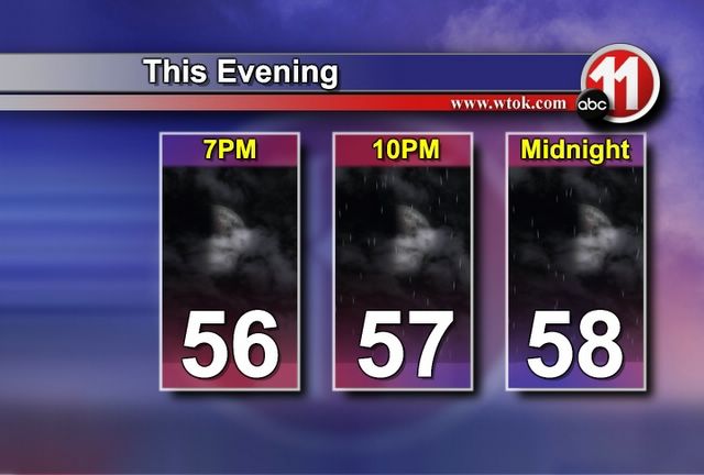
Temperatures are expected to hold steady this evening as rain begins to fall across the area. Rain will be spotty tonight, before filling in across the area on Sunday.

United Way Needs Your Help
* As discussed on our Town Hall Meeting last night on Fox Meridian, our local United Way needs your help. The United Way helps numerous local organizations...Boy Scouts, Hope Village, and Boys and Girls Club (among many others) all receive funding from the United Way. When Katrina ravaged our area, many of these organizations were stretched thin financially. This financial burden worked itself up the chain to the United Way. Without a financially able United Way, our community would suffer immensely.
* If you are financially able and willing, the United Way could use your help. Officials with United Way say that one hour's worth of your salary per month is a "fair share." Seems like a very "fair share" to pay to insure that our community's well-being remains intact.
* If you are able and willing to help, please do. You can donate via the internet at
www.unitedway.com or via telephone at (601) 693-2732.
* 1% of your donation will go to the national office of United Way...Which means that 99% will stay right here at home and go straight to the organizations that sorely need them.
* I'm off for the weekend - heading to Mobile, Alabama. I hope you have a stress-free and fun weekend with your family. Try to stay dry!
Showers with heavier patches of rain embedded in them continue to move northeast through our area. The majority of the rain will stay east of a line from Macon to Meehan to Laurel through the rest of the night. If you're out driving, be sure to watch for ponding on area roadways.

Intermittent showers will continue tonight as moisture continues to increase. We expect a decrease in the number of showers tomorrow, but more rain is on the way Sunday night into early Monday. The rain event Sunday/Monday will be the more significant of the two - rainfall amounts of one to two inches are likely in some locations.

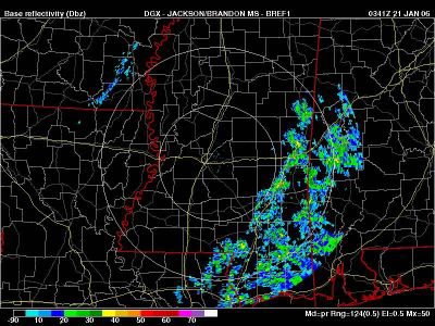
Scattered showers are developing across southeast Mississippi. These showers will affect much of our area, especially along and east of Mississippi Highway 15. Rainfall amounts will be light (less than 0.15").
Tonight will feature gradually falling temperatures, with clouds slowly increasing from the west. Low clouds and fog are possible early tomorrow morning...
United Way Town Meeting
*
United Way will be holding a town meeting to discuss their need for donations tonight on Fox Meridian at 9pm. Be sure to watch, and if you are in a position to help, please do. With all of the needs still around from Hurricane Katrina, the financial burden on our local charities is rather stiff.
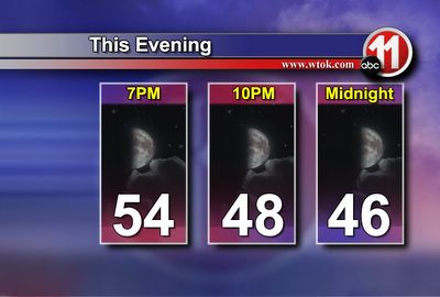
* Changes are on the way, and those will begin soon. A front is picking up steam across the Plains, as an area of low pressure forms just east of the Rocky Mountains. In fact, NWS offices in Colorado are calling for upwards of a foot of snow in the Rockies - this is a near perfect snow setup for our friends in Colorado.
* No snow here, but this system will have a big impact on us. The area of low pressure will track along a frontal boundary that will move towards us tomorrow. Moisture will increase through the day, and a shower is possible tomorrow afternoon. However, the vast majority of the rain will hold off until Friday night and Saturday morning.
* Rain and thunderstorms will be a big part of the weekend, especially during the hours before noon Saturday. We'll forecast a decrease in the coverage of rain by late Saturday night into Sunday. We will not stay dry during this period, however, there will still be a few showers around.
* Another wave of low pressure is forecast to track along the front Sunday night into Monday. This will bring an accompanying wave of rain with it - and we cannot rule out a rumble of thunder. However, the threat of severe weather at any point this weekend is very low. The best dynamics will pass well north of here, and instability values will stay too low to support widespread severe weather.
* We're making changes to our website over on
www.wtok.com/weather. Be sure to check those out, and if you have anything you'd like to see added, let me know.
Gatlinburg Trip...and Weather Update
* As advertised, I've posted a bit of a rundown and some pictures from my trip to Gatlinburg, TN over the weekend. The Smokies are one of my favorite places, and I heartily recommend a weekend up there as a family or group of friends. Scroll down for pics and brief descriptions. If you're going up there and want a recommendation on a great place to stay, e-mail me at josh.johnson@wtok.com. Our group was very pleased with our accommodations.
* In the world of weather...I can't help but notice the cold air building across Russia. Pevek, Russia reports -26 degrees F at the 3:00 hour, and many other cities across Polar areas are reporting record cold temperatures. While the upper air pattern won't allow any of that to head our way at the moment, I believe we will see a turn to dramatically colder weather for early February. And, if the subtropical jet continues to be active and transport moisture in here, we could have at least the chance of some wintry weather at some point during the first half of February. I am NOT forecasting snow - just a general discussion of the weather pattern for February.
* Closer to here and now...Our rain chances are low until Friday, when moisture will really begin to move in to the Deep South. Showers and a thunderstorm are likely Friday night into Saturday morning. The best chance of a thunderstorm and some heavy rain will come along and south of U.S. Highway 80. Any severe weather should be very, very isolated - and near the coast. Instability values this far north do not support severe thunderstorms.

Rain that had fallen on us during our drive changed over to snow by late Friday night. We are just beginning to see some accumulation in this image.

When we woke up Saturday morning, our chalet was covered in snow. We picked up just under two inches!
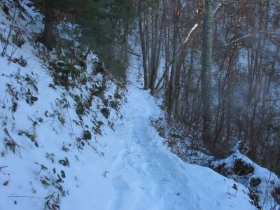
This image is from the Sugarlands Mountain trail, just between the National Park Welcome Center and Elkmont. A very enjoyable Sunday hike for our group!

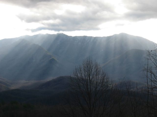
This image was taken Sunday afternoon, and has a spectacular view of Mt. Leconte. The image also captures crespucular rays, or sunbeams that shine down through the clouds. The snow had mostly melted in our location, but there was still a decent amount of snow on the ground in the Great Smoky Mountain National Park. If you've never driven U.S. 441 from Gatlinburg to Cherokee, NC in the winter, I heartily recommend it.
Rain Moving Out...
* Quite a soaking rain fell across Mississippi and Alabama today. Here are some regional rainfall amounts:
Meridian 1.73"
Jackson 1.39"
Muscle Shoals 2.31"
Birmingham 1.01"
* Rain is changing to snow across western Tennessee. Memphis, TN and Jackson, TN have both reported some light snow during the past couple of hours. This snow will remain well north of us. However, we may see a flurry or two across northernmost parts of our area - roughly along and north of Highway 14. Even if we do, it will not be a big deal. The ground is warm, and any flurry that falls will be very, very light. But, we'll watch it.
* The rest of the week looks fairly calm. We'll be in a zonal flow pattern, which means a system every few days. Our next one will bring rain and thunderstorms through late Friday into Saturday. Some could be strong, but its too early to speculate on the extent of any severe weather threat.
* Thanks to Renny Vandewege for filling my shifts Friday night and Monday night. I was in Gatlinburg, Tennessee for a wonderful vacation. I will post tomorrow with a complete rundown of our trip - and some fantastic snow pictures!
Wild Weather
* Quite an interesting forecast is shaping up for the next 3 days as we continue with a highly amplified, progressive pattern. A large trough is taking form across the western US. As it moves eastward, it will strengthen and deepen. Ahead of it, a large transport of moisture will return through a large depth of the atmosphere, which will aid in heavy rain fall with the thunderstorms we expect to develop.
* The first round arrives on Monday with the lead shortwave embedded in the trough. A squall line should develop and push through. Heavy rain is certainly possible. There is a slight chance of severe weather, however there is a big lack in instability. If any severe weather does occur, it will likely be in the form of damaging winds. Hail and tornadoes do not look likely at this time.
* Rain continues overnight Monday and then into Tuesday as the cold front pushes through. Once again, another strong squall line should move through and heavy rain and winds look like the main concern here. Overall, we could easily pick up over 2" of rainfall. We could certainly use the rain.
* If heavy rain isn't enough, the front pushes through during the day Tuesday, but it looks like the core of the coldest air aloft won't pass until overnight Tuesday into Wednesday. That being said, the forcing caused by the passing of the strongest dynamics should be enough to touch off precipitation behind the front as we start the day Wednesday. What kind of precipitation will we see? That is the million dollar question. It is certainly possible that we could see a little mixing of rain and snow as we start the day Wednesday. Right now, accumulating snow doesn't appear in the cards. This again is several days out and we'll be continuing to watch each run of the model for tendencies before we can ultimately refine our forecast. Nevertheless, It is a wild and fun forecast -- one reason I love this job!
* Time to watch some football. Hopefully the Colts can turn this thing around. I know Heather Cook would be happy! Have a great weekend!