Heavy Rain Possible
* A band of heavy rain and a few embedded thunderstorms continues to push east and northeast through Central Mississippi. These will push into our entire area by midnight or 1:00am. Severe weather is unlikely, however there could be a report or two of gusty winds. The main threat is still heavy rain. The rainfall will make its way through the area by tomorrow morning. Skies will clear out tomorrow afternoon leaving us with a pleasant, warm afternoon as highs get into the lower 70s.
* If you come across standing water on roads, please use extreme caution. Ponding on roadways creates a very slick surface. Also, if you come across any flooded roads, remember the saying "Turn around don't drown!"
* Have a good weekend!
Interesting Times Ahead...
* The next month or so will offer some very interesting times in the world of weather. First, we have a pretty decent rain event shaping up for this evening and tonight. Showers and thunderstorms will overspread Mississippi and Alabama from the west. Most of the rain should hold off until after noon at the earliest, with the vast majority of it falling after sunset Saturday.
* There is some chance of an isolated strong or severe thunderstorm Saturday night. The wind shear in the atmosphere is more than sufficient for severe weather, but the amount of low level moisture and instability seems to be inadequate. IF there is more moisture return than current projections, then the chance of severe weather will increase. Renny will be here watching things closely.
* Sunday looks mostly dry, with a shower possible early. Another upper trough will swing through Monday, with an outside chance of a shower.
* The long range still looks chilly and unsettled. The GFS hints at a cold period around the second week of February, with an active southern branch. We'll continue to watch...
NWS Newsletter
* I received this note in the e-mail inbox from NWS Meteorologist-In-Charge Alan Gerard from the National Weather Service in Jackson this afternoon...Good stuff!
All,
NWS Jackson meteorologist Ashley Wester has put together a great
newsletter showing the latest happenings at your NWS office. Check it
out at the following website:
http://www.srh.noaa.gov/jan/TheArklamissObserver2.pdfAlan Gerard
MIC NWS
* Will post this evening with a detailed discussion about our severe weather potential for this weekend...
Cold February?
* First, this weekend looks wet at times. The first bout of rain will come late Saturday afternoon and last through Sunday morning. We'll see a break in the action Sunday afternoon, with more showers on the way for Sunday night into Monday morning. Much colder air will steam into the Deep South behind this second system, as temperatures Monday will likely fall through the 50's.
* We continue to note the massive buildup of cold air across parts of Alaska and the North Pole. An evaluation of a few teleconnections indicates that some of this could be heading southward in the next few weeks. Teleconnections are great forecasting tools. By evaluating the current weather in other parts of the world, we can get a good idea about what our weather might do. The primary teleconnections we use are the SOI (Southern Oscillation Index), NAO (North Atlantic Oscillation) and AO (Arctic Oscillation). Negative values of the NAO and AO often indicate a trough in the East. Assuming there is cold air in the source region (Canada, Alaska, Siberia, the North Pole, etc.), this frequently leads to a major intrusion of cold air. We'll watch it clsoely.
Quick Update on Alaska
* Alaska? You might be asking what that has to do with our weather. A lot. Bitterly cold air is building in Alaska right now, and there are indications that the upper air pattern could allow some of this to move our way in the next 10-15 days or so.
* 2pm observations:
- Arctic Village, Alaska -36F
- Kaltag, Alaska -38F
- Lake Minchumina, Alaska -44F
- Galena, Alaska -45F
- Tanana, Alaska -49F
- Fort Yukon, Alaska -54F
* For a complete rundown of Alaska temperatures, check out this website:
Alaska Hourly Observations* Scroll down for our thoughts on the weekend...
Focus on the Weekend..
* The rest of the work week looks fairly tranquil. Highs will be cool, but nothing terribly cold at all. A few high clouds will move overhead late tomorrow and into Friday.
* Our focus here will be on the weekend. A negatively tilted trough will be pivoting through the central U.S., spawning a surface low in the central Plains Saturday evening. Showers and thunderstorms will form to our west Saturday afternoon and begin moving across Mississippi and Alabama.
* Computer model guidance continues to disagree on the exact evolution of this system. The NAM (North American Mesoscale) model suggests that the rain and thunderstorms will hold off until Sunday, while the GFS is a bit faster - it brings thunderstorms into central Mississippi by Saturday evening.
* Instability will be limited, but there should be enough to warrant at least the chance of strong thunderstorms Saturday night and early Sunday morning. We'll continue to watch the latest computer model guidance in coming days...
Chris Brennaman's Newscenter 11 Blog
* It's great to see some of our friends from the News Department getting involved in the world of BLOGGING. Reporter Chris Brennaman has started a Newscenter 11 Blog - it details life in the world of a news reporter, and he often discusses stories going on in our community. This will be a great site to check, simply because Chris will have the freedom and time that he doesn't always get on TV to tell his story. Check it out:
Chris Brennaman's Newscenter 11 Blog

Temperatures will fall through the 40's tonight, as clear skies and light winds allow us to cool off a bit more than last night. We'll reach the lower 30's by early tomorrow morning.

Bright, Bright Day
* What a nice day. Bright blue skies and sunshine have resumed across Mississippi and Alabama today. It is a bit breezy; winds at Key Field have been gusting above 10 mph at times.
* The rest of the work week looks fairly tranquil. Dry weather will rule the roost until at least Friday, but a few clouds will roll in Thursday and Friday. Rain chances begin to increase late Friday, as a strong upper trough swings through the central Plains. This trough will interact with a warm and moist airmass and bring a round of showers and thunderstorms Saturday and Sunday. Like last weekend, there is again the potential for a drenching rain. The highest threat of any flooding will come across northwestern Mississippi. But, the Tombigbee and Pearl Rivers are still swollen from recent rains, so we'll have to watch for some flooding problems there.
* Also, the airmass will have some time to destabilize. That fact, coupled with the strong upper level dynamics, could set the stage for a few strong thunderstorms over the weekend. We'll continue to refine our weekend forecast through the rest of the work week.
Strong Temp Gradient
* Our formerly stalled front is picking up steam...It's now moving through the Deep South. There is still a very tight temperature gradient on either side of the front. Check out these recent weather observations:
South of the front (warm sector)
Mobile 75
Pensacola 73
Albany, GA 73
North of the front (cool sector)
Meridian 57
Birmingham 61
Atlanta, GA 52
* The rain is moving out fairly quickly from the west. Rainfall amounts were widely variable across on our area, but most of us managed to pick up at least half an inch.
* Dry weather will resume for most of the remainder of the work week. Our next system will approach from the west, bringing another chance of rain and thunderstorms by the weekend.
THE NATIONAL WEATHER SERVICE IN JACKSON HAS ISSUED A
* TORNADO WARNING FOR...
EASTERN SIMPSON COUNTY IN CENTRAL MISSISSIPPI
THIS INCLUDES THE CITIES OF...MENDENHALL...MAGEE * UNTIL 630 PM CST
* AT 542 PM CST...NATIONAL WEATHER SERVICE DOPPLER RADAR INDICATED A SEVERE THUNDERSTORM CAPABLE OF PRODUCING A TORNADO 12 MILES SOUTHWEST OF MAGEE...MOVING NORTHEAST AT 25 MPH.
* THE TORNADO IS EXPECTED TO BE NEAR... MAGEE AND 7 MILES SOUTHEAST OF MENDENHALL BY 600 PM CST SEEK SHELTER ON THE LOWEST FLOOR OF THE BUILDING IN AN INTERIOR HALLWAY OR ROOM SUCH AS A CLOSET. USE BLANKETS OR PILLOWS TO COVER YOUR BODY AND ALWAYS STAY AWAY FROM WINDOWS.
Very Strong Wedge
* You often hear us throw around the word "wedge". That's what occurs when cold air tries to move westward from New England. It runs into the Appalachian Mountains and is funneled southward - in the general direction of the Carolinas, Virginia, and Georgia.
* Great example of the wedge right now. Atlanta, Georgia is sitting at 45 degrees right now. Birmingham, Alabama is 71. That's a 26 degree difference!
* The "wedge" is a very efficient ice storm producer for our neighbors in the Carolinas and Virginia. They will get some freezing rain later tonight.
* Back home...No ice, but some thunderstorms and areas of rain. There is a very small threat of a severe thunderstorm or two, but the main thing we'll be watching for is heavy rain later. The strongest thunderstorms right now are running from Pelahatchie to Mendenhall to Monticello. Movement is north-northeast at 30 mph. These storms will affect mostly along and west of Highway 35 through the next several hours. Again, there is a small chance that one or two of these storms could become briefly severe. Main threat to safety will be ponding on roadways because of heavy rain. Slow it down out there tonight!
Sunday Afternoon Update
* Greetings from Mobile, Alabama...I've been watching a bit of the NFL playoff game today between the Steelers and the Broncos. So far, the Steelers are in control of the game. But, enough of the sports chatter; we'll leave that to Lindsey and Heather.
* A band of thunderstorms has developed across central Mississippi. This line runs roughly from northernmost Rankin County back southward towards McComb. Some of these thunderstorms have warranted severe thunderstorm warnings this afternoon.
* I note that dewpoint values have risen into the 60's. Temperatures are in the 70's. This will lead to a more unstable airmass. With that in mind, we'll amend the forecast to include a slight risk of severe thunderstorms this afternoon and evening. But, we still do not think this is going to be a very widespread event. The main threat will be isolated reports of hail or gusty damaging winds. We can't rule out a tornado, but the threat sure doesn't look that significant.
* Still, this is a good afternoon to stay close to a good source of weather info (NOAA Weather Radio, WTOK, WMOX, our Wireless Weather product) Hope you are enjoying the weekend...
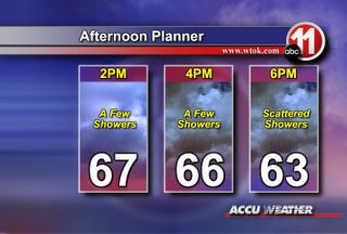
A few showers will be possible this afternoon, though most should remain light. We will see an increase in activity as we head into the evening hours. Showers and a few thunderstorms will continue tonight, some rain could be heavy. Remember that ponding on the roadways could create isolated slick roads, so be sure to use caution if driving in heavy rains!


