1:00 PM Update
* Temperatures have warmed into the mid 40s this afternoon across the area. Not expecting much in the way of snow showers this afternoon (especially with temps so much above freezing). The 12z upper air sounding from Jackson, MS showed a large area of dry air in the mid levels. This is confirmed on water vapor imagery. The past few hours though have shown that dry patch of air moving south and east and I'd imagine the 0z sounding this evening will show more moisture within the column of air.
* Water vapor imagery also showing that the core upper level trough is hanging back and spinning about in Missouri at this time and continues to move southeastward. The late arrival will eliminate snow showers today, but could make them possible this evening. Lapse rates should be more than sufficient for convection to occur and with temperatures falling off this evening, precipitation will likely fall as snow. As we've mentioned previously, a dusting at most would occur underneath a heavy snow band. But we do not expect travel troubles or accumulation, if any snow at all. We'll watch this closely. Also, its a bit breezy out there this afternoon with winds from 10-20 mph and higher gusts! Certainly feels much cooler than the actual temperature would suggest!
Brisk Morning
* Just getting back from the Pregame Show over on 103.3 FM with Lindsey Hall and the gang. Always a fun time hanging out, talking sports, talking a little weather, and the occasional tangent on whatever comes up. Be sure to check out next weekend as my wonderful mother, Linda, joins us in studio! Looking forward to having her come down!
* Checking out a few things this morning. Noticed a few snow showers up in north Mississippi this hour. If you've been out this morning, you know the word "cold" would summarize things quite well. Temperatures in the low 40s with a brisk wind has wind chills in the lower 30s. Be sure to bundle up! As the cold air aloft (upper level low) swings over the top this afternoon, we'll see an increase in clouds and possibly a few convective snow showers. This is rather rare to have convective snow showers in the Deep South. These are more common in the northern plains states. We certainly don't expect any travel trouble problems around here. But if one snow shower sets up over your house, grassy surfaces may become white.
* Enjoy your Saturday and I'll be keeping an eye on radar throughout the day and providing updates...and maybe a fun post or two...as the day moves on.
2:00 AM Update
* It sure looks like the chance of any changeover tonight is gone. The rain is sweeping out of the area quickly, and temperatures are still in the 40's. But, our chance of seeing a few flakes fall is not completely dead...
* A deep pocked of cold air aloft (we often refer to these as upper air troughs) will move through tomorrow. This, combined with some residual moisture from the departing surface low, should be enough to get a few snow showers to develop. We don't anticipate much accumulation, but if one of the heavier showers sets up over you, it may be enough to turn the grass white. It doesn't look like a big deal, but we all know that snow can offer up surprises some times...We'll watch it.
* Interesting drive for me tonight. I drove from Meridian to Mobile, Alabama after the 10 pm news to visit my girlfriend Tara for Valentine's weekend. It rained the entire way, and I even saw some lightning in Waynesboro and Yellow Pine, Alabama. Also interesting was crossing the cold front as I drove southward. The temperature, as measured by my car thermometer (usually accurate +/-2 degrees) in Citronelle, Alabama was 49 degrees. Just 20 miles south, in Saraland, Alabama, the car thermometer showed 57 degrees. I also saw very vivid lightning upon my arrival into the city of Mobile.
9:15 Progress Update
* Before we get to the wintry weather unfolding to our north, a quick note...Please slow down on area roads tonight. Ponding on roadways has created an enhanced risk of hydroplaning. Minor street flooding is continuing to occur in some locations, so exercise caution tonight if you must be out.
* Interesting reports coming in from northeast MS...Snow is turning the ground white in Iuka (NE corner of the state). Snow has also been reported in Florence, Alabama - just across the MS state line.
* Our forecast remains unchanged - mostly rain here, with the possibility of a few wet snowflakes mixing in with the rain early tomorrow morning. The best chance of that would come north of Highway 16, and frankly, it seems unlikely even there. But, we'll continue to mention the possibility.
* Perhaps our best chance of snow will come tomorrow. Very cold air aloft will result in instability, and this unstable airmass will likely cause some convective snow showers. While they won't last long, they could produce enough snow to turn the ground white in places.
* Be sure to scroll down for some great pictures from northwest Mississippi, courtesy of Todd Beal.
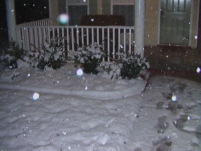
Footprints in the snow (and this photo) are courtesy of my good friend Todd Beal. These were taken in Olive Branch, MS. Time: 7:25 pm.


Image taken in Olive Branch, MS, around 7:25 pm.

These pictures were taken in Olive Branch, Mississippi, a Memphis suburb, around 7:25 pm. A nice wintry scene! Courtesy of Todd A. Beal, LDCT.

Here's our latest thinking about the potential for winter weather in the Southeast. A dusting is possible along and north of I-20. To the north, a significant winter storm will affect northern Alabama, northern Mississippi, and much of Tennessee. We'll have to watch for the possibility of some snow showers tomorrow as the upper trough swings through here. Those snow showers have the potential to turn the ground white in places. We will continue to closely monitor the situation...
Quick Evening Update...
* The 0z computer model guidance is rolling out, and I thought it would be a good time to refine the forecast a bit...We will continue to go with the idea of mostly rain here, with a few snowflakes possible Saturday. Here's our overall forecast for the system...
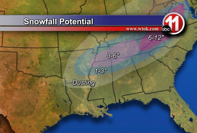
MOSTLY SNOW north of a line from Grenada, Mississippi to Fort Payne, Alabama. This includes Memphis, Tupelo, Muscle Shoals, Huntsville and Nashville. The potential exists here for serious travel problems, as 6-10" of snow is possible somewhere in this area.
MOSTLY RAIN north of a line from Philadelphia, Mississippi to Birmingham, Alabama. While we can't rule out a few snowflakes mixing in with the rain, we don't expect any accumulation in this area. That being said, a few snow showers seem like a good bet for Saturday. I suppose its possible that the ground could turn white under one of the heavier snow showers. But, no travel problems are anticipated.
ALL RAIN south of the line from Philadelphia to Birmingham...But, again, I would imagine this area could see some snow flurries or snow showers Saturday. No travel problems expected.
* I will create a graphic tomorrow to illustrate our latest thinking...
Weekend System Update
* The 12z model data has arrived, and it appears we'll need to revise the forecast just a bit. Around here, the forecast will stay much the same - mostly rain. However, we will take out the chance of a changeover to snow Friday night. Here's the latest thinking:
SNOW will fall roughly north of a line from Little Rock, Arkansas to Knoxville, Tennessee. The potential is there for a major winter storm in this area. So, if you have travel plans to Nashville, Memphis, Little Rock, or other areas up the East Coast, be sure to check ahead.
Around here, we expect an area of rain and thunderstorms to move through Friday and into Friday night. The rain will move out before the cold air arrives, so no changeover to snow is likely.
However, snow fans shouldn't completely get discouraged. The deep upper trough will pass overhead on Saturday, and I would imagine we will squeeze some flurries or light snow out of that. Perhaps even enough to dust the ground in places.
Forecasting winter weather in the South is a difficult challenge, so be sure to check back here and on Newscenter 11 at 5,6, and 10 for updates...
Winter Weather Potential...
* Quick update after reviewing the 0z NAM (North American Mesoscale) model this evening...
* This run suggests that the majority of precipitation here will fall in the form of rain, with the possibility of mixing with or changing over to snow before ending. Areas north of here (Tupelo, Columbus, Huntsville, Muscle Shoals - and on into the Carolinas and Appalachians) could see a very significant winter storm out of this.
* We'll mostly stick with the going forecast, with maybe a minor adjustment or too...Our latest thinking is....
MOSTLY SNOW north of a line from Grenada, Mississippi to Gadsden, Alabama. The potential exists here for 4-7" of snow. This includes places like Tupelo, Huntsville, and Muscle Shoals.
MOSTLY RAIN north of a line from Jackson, Mississippi to Alexander City, Alabama. This includes Meridian, Philadelphia, Macon, Demopolis, Livingston, York, and other communities north of roughly U.S. Highway 80. The rain could mix with or change over to snow Friday night. Snow accumulations seem unlikely at this point in time.
ALL RAIN south of a line from Jackson, Mississippi to Alexander City, Alabama. This includes places like Quitman, Bay Springs, Waynesboro, Grove Hill, and other communities roughly south of U.S. Highway 80. While we can't rule out a snowflake or two Saturday, that doesn't seem likely.
* I want to emphasize the uncertainty still remaining in this forecast. There are many factors that we'll have to closely monitor. Some of these factors could cause widespread and drastic changes to this forecast. We'll have to watch the progress of low-level cold air. If more cold air "seeps" in than our models indicate, this could lead to some ice. Another issue is the very deep, dynamic trough set to move through Saturday. These upper troughs can often serve up some major surprises...
* Another update to come tomorrow morning...
Afternoon Update
* Trying to get caught up on TV graphics as I type this, so forgive the brief and segmented nature...
-- System tonight will not be a big deal for us. Perhaps some accumulating snow across NE AL and parts of central TN. An outside chance of a sprinkle, but most places will stay dry.
-- The more interesting system of the two comes Friday night into early Saturday. The key to this system will be how much warm air moves in aloft as the system approaches. We call the movement of warm air "warm air advection" (WAA) - and how much WAA we get will play a key role in determining if we see a cold rain or some snow or ice. Right now, it appears that we will see the majority of precip here fall in the form of rain, with a possible changeover to snow. The best chance of this snow would come north of I-20 and east of the Alabama/Mississippi state line.
-- The potential is there for a significant bout of winter weather...Exactly when and where remain to be seen...But, we will try to be as specific as possible. Just keep in mind that this WILL change in some fashion before Friday night. But, as of now, this is what we're thinking...
Mostly light snow along and north of a line from Grenada, Mississippi to Birmingham, Alabama. This is north of our area and includes places like Starkville, Columbus, Tupelo, Hamilton (AL), etc...Some snow accumulation is possible in these areas.
Mostly rain, perhaps mixing with or ending as snow...north of a line from Jackson, MS to Auburn, Alabama. This includes the northern half of our area - roughly along and north of U.S. Highway 80. Includes Meridian, Philadelphia, Demopolis, Livingston, Macon, and Greensboro. Snow accumulations are not likely, but some areas could see areas of slushy wet snow on grass and elevated objects.
South of that line should be mostly rain, with a few snow flurries possible Saturday morning as the storm departs. No accumulation expected at this time.
***I want to urge that this is a very preliminary "rough draft" of the forecast. There will be changes made to these areas I've highlighted through the next 48 hours. We simply want to give you an idea of what we're thinking, and at least begin the forecast process***
Winter Weather Potential
* We have a couple of chances at seeing a snowflake or two during the next 7 days. We'll take them in order....
* Wed. Night -- this looks like a very minor deal. The vast majority of precip will stay well to our north. There could be a light dusting of snow along and north of a line from Vernon to Anniston in northern Alabama, but nothing significant should come of this system.
* Thursday and Friday will feature cold and mostly dry weather. But, changes will begin Friday night. An area of low pressure will form in the northern Gulf of Mexico Friday afternoon. This will spread moisture over the top of a cold airmass. This is the type of setup that historically can produce snow in the Deep South. There are so many unresolved details with this system, so we'll just continue to refine our forecast as we approach the weekend.
SVR Warning Jasper
BULLETIN - EAS ACTIVATION REQUESTED
SEVERE THUNDERSTORM WARNING
NATIONAL WEATHER SERVICE JACKSON MS
243 PM CST MON FEB 6 2006

THE NATIONAL WEATHER SERVICE IN JACKSON
HAS ISSUED A

* SEVERE THUNDERSTORM WARNING FOR...
 NORTHERN JASPER COUNTY IN EAST CENTRAL
 MISSISSIPPI

* UNTIL 330 PM CST

* AT 243 PM CST...NATIONAL WEATHER SERVICE
 DOPPLER RADAR INDICATED A
 SEVERE THUNDERSTORM CAPABLE OF PRODUCING
 PING PONG BALL SIZE-HAIL.
 THIS STORM WAS LOCATED 9 MILES NORTH OF
 BAY SPRINGS...OR ABOUT 17
 MILES SOUTHWEST OF NEWTON...AND MOVING
 EAST AT 40 MPH.

* THE SEVERE THUNDERSTORM WILL BE NEAR...
 7 MILES NORTH OF PAULDING BY 305 PM CST
 ROSE HILL BY 310 PM CST
Winter Weather Chances...
* A close call for our friends in northern Mississippi and northern Alabama tonight. Snow has been reported as far south as Birmingham tonight, and light snow accumulations seem likely along and north of US 278. We are far too warm for any snow, but we do anticipate a cold rain throughout much of Monday. The rain will taper off, and much colder weather will continue.
* Our next system of concern comes through Wednesday in the form of a shortwave trough embedded in the larger overall trough. We call these systems "clippers", and they generally are very moisture starved. However, it's conceivable that we could see some light rain or snow flurries Wednesday night with this system.
* Cold weather continues for late week. By the weekend, model guidance suggests the possibility of an area of low pressure forming along the Gulf coast and tracking south of here. If that were to verify, the potential would exist for some snow. Forecasting winter weather is difficult 6 hours in advance, much less 6 days. But, we want you to be aware of the possibilities.
* Snow or not, it sure looks cold for the weekend. Highs will struggle to reach 40 degrees by Sunday, with a very cold airmass in place. Winter isn't over just yet...I'll have another update Monday evening.