Rain Coming Soon...
* LIVE TV: Our 10:00 PM newscast tonight (Friday) was a real adventure. First, I was neck-deep in a global warming discussion online, and committed the cardinal sin of not paying attention to the newscast...Whoops - first weather rolled around, and I was sitting down, deep in discussion. Then, the weather computer went kaput during main weather. Some days you just can't win.
* Rain Arriving: Rain becomes likely by tonight and into tomorrow. The rain could be heavy at times; some communities could wind up with over one inch of rain.
* Next Week: Still a lot of uncertainty in this forecast. Rain chances will linger, and chilly temperatures will continue. There is growing evidence that a major intrusion of Arctic air could occur late next week. We'll see...
* FOOTBALL GAMES: The AFC and NFC Championship games are both on Sunday. The Saints play the Bears in Chicago at 2:00 PM. For that game, we anticipate some lingering snow with temperatures in the middle to upper 20's. VERY cold! That game is being televised on Fox Meridian.
The Patriots travel to Indianapolis to play the Colts in the RCA dome. The game is inside the dome, so weather is obviously not a big concern; but we do expect snow for the city of Indianapolis on Sunday. Kickoff from Indy is at 5:30 PM.
* Hope you have a wonderful weekend!
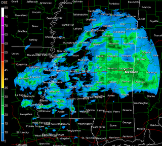
Manchester or Meridian?
* The weather sure feels British this afternoon and evening - it's cold, gray, and we are dealing with mist and scattered showers. Temperatures were stuck in the 40's for most of the day.
* RAIN This Weekend: Rain chances will max out late Saturday and into Sunday - the rain could be heavy at times. The good news is that temperatures will warm up enough to guarantee only rain with this bout of precipitation.
* Clear as Mud: That's the best way I can describe the forecast for next week. The subtropical jet will keep rolling moisture across the area, and cold air won't be far away. Those two ingredients being so close to each other will make for an interesting week or two.
More Rain, Some Sleet
An area of light rain, mixing with a few sleet pellets at times, continues to roll from west to east across our area. Temperatures are well above freezing, so we expect no travel issues.
* We continue to watch this unsettled pattern unfold. A cold, soaking rain is likely here over the weekend with the next storm system. Temperatures should be warm enough to support only rain here, but some wintry precipitation is possible across northernmost reaches of Alabama and Mississippi, and most of Tennessee. Travel plans to those areas should be well-researched in coming days, there could be significant travel issues along the I-40 corridor.
* The forecast for next week is not very clear. We expect an area of low pressure to form in the northwestern Gulf of Mexico, and this will throw moisture up over the cold air in place. There is some threat for some wintry weather in the area with this system, but confidence in the forecast remains very low. Be sure to check back here for frequent updates throughout the next week or so.
More Rain, More Sleet...
* Another band of rain mixed with sleet is pushing through the area...Temperatures are well above freezing in most locations in our area, so we expect no travel problems for most of us. The exception comes for the Miss. Highway 35 corridor. There, we could see a few icy spots on bridges or overpasses - places like Carthage, Forest, and Morton.
* Yet another wave of precipitation will sweep across the area later this evening, and it too will have some sleet mixed in with the rain. Temperatures should again stay above freezing for that band as well, with no major travel concerns.
* REPORTS AND PICTURES: The best method of determining what's happening on days like today is ground truth. So, we need your reports! Let us know what's happening in your community by leaving a comment on this post.
Dry For Now...
* The mixture of sleet, freezing rain, and rain has pushed out of the area for now...Roads are simply dry, but there is a very light glaze on stairs, decks, cars, and mailboxes, so watch for that this morning.
* More sleet? Sleet and rain are again possible later this afternoon and into tonight. Again, it appears that temperatures will be above freezing, and we do not anticipate big travel problems.
* Cold to stay: Cold weather will continue through most of the work week. Afternoon highs will struggle to reach the middle 50's. Another system will approach this weekend, and temperatures will again be borderline for some wintry precip. At this point, I believe we'll deal with a cold rain over the weekend.
* Winter Pattern: It seems that we will stay locked in to a fairly cold and wet pattern for the next seven days. This is a favorable pattern for SOMEONE in the South to get some wintry precip - could be Tennessee and Arkansas, or it could be farther south...Too early to tell.
Some Pics...
Here are some images of the light ice accumulation from this evening's freezing rain and sleet mixture...Click on the images for a larger picture...


10:15 PM Update
* The shield of precipitation back across LA/TX continues to expand and increase in intensity. This could lead to bridge and overpass icing late tonight into early tomorrow morning. Here's the latest update from NWS Jackson:
Winter Weather Advisory* The greatest threat of icing continues to be along and south of a line from Jackson to Macon to Eutaw, Alabama...
* REPORTS and PICTURES: We've gotten a few reports in on this space already, but we could sure use more of your information! Either leave a comment with your time, location, and report...Or, e-mail me any pictures you may take of the glaze (cars, mailboxes, etc.) to josh.johnson@wtok.com
A Light Glaze..
* A thin, rough glaze of ice has formed on cars and other elevated objects tonight. The roads are fine - just a little wet. However, we will continue to stress that we might see some slick spots on bridges and overpasses tonight and early tomorrow morning. So, be very careful.
* REPORTS and PICTURES: We've gotten a few reports in on this space already, but we could sure use more of your information! Either leave a comment with your time, location, and report...Or, e-mail me any pictures you may take of the glaze (cars, mailboxes, etc.) to
josh.johnson@wtok.com* Still no major changes in our thinking...No big worries, just a few slick spots. But, these nights can change on a dime, so keep checking this space for updates throughout the duration of the next 24 hours.
Evening Update
* Just had some light rain and sleet fall along S. Frontage Rd. in Meridian...
* We will go ahead and amend the forecast to include the possibility of snow flurries mixing in with the rain/sleet mixture. The latest upper-air data suggests that in some places, the entire column of atmosphere will be below freezing - that suggests some snow is possible.
* Still thinking no big problems - but there could be some isolated slick spots, especially on bridges and overpasses.
* These events can offer up some surprises, so check back here and keep watching WTOK throughout the night and into tomorrow morning. If things change drastically, we'll let you know.
*
NEED YOUR REPORTS: The best way for us to know what's happening is for you to tell us what you're seeing! Simply leave a comment here with a time, location, and weather report...If you hear from a friend or family member of a report in another location, feel free to post it too. I'll watch throughout the night and use these reports tonight at 10.
Winter Weather Advisory Issued...
* NWS has issued a Winter Weather Advisory for our Mississippi counties along and south of I-20. This includes Forest, Newton, Meridian, Clarkdale, Waynesboro, Laurel, Bay Springs and other cities in the area south of I-20.
* This has been issued for the possibility of some light sleet or freezing rain issues on bridges tomorrow morning. Barring any major changes, this will not be a major ice event - but still, you should exercise caution tomorrow morning, especially on bridges and overpasses. You might want to wake up a few minutes earlier than usual so that you can get the latest forecast before making the trip to work.
* I should again say that we do not anticipate a major ice event. The ground is very warm, so as long as the precipitation stays mostly in the form of sleet, we shouldn't have any issues with power outages or widespread icing.
* We'll be watching closely, these things can offer up some surprises...We'll be along at 5, 6, and 10pm with a full update.
Winter Returns in Full Force!
Over the next 24 hours the forecast looks very interesting. The transition from near-record temperatures to highs in the 30's is a very hard adjustment, and i would suggest getting out the coats and scarves now. Temps today will slowly fall into the lower 40's by midnight with showers becoming more numerous across the area.
For Tuesday, the HIGH will occur at MIDNIGHT. Temps will slowly fall into the upper 30's throughout the afternoon. With a few lingering showers and frigid temperatures, your Tuesday is going to be just down right uncomfortable.
As far as wintry precip goes.......
A matter of a couple of hours could make a huge difference as to whether or not some places in our area see some sleet. The arctic air seems to be lagging a bit, meaning the moisture should exit the region before we see freezing temperatures. However, a few sleet pellets can't be ruled out in the northwest portions of our viewing area, especially if the moisture sticks around a little while longer. Personally, it looks to me that all precip should stay in liquid form. Keep in mind, though, that some roadways will be slick whether we do see some sleet or not.

