A Real Gullywasher...
* Here are some rain totals from yesterday/early this morning:
Meridian (Key Field): 2.39"
Tylertown: 3.20"
Kosciusko: 6.53"
Raleigh: 4.47"
Yazoo City: 7.75"
Canton: 5.82"
Thomasville, AL: 2.04"
Birmingham: 1.72"
Tuscaloosa: 3.78"
* 7.75" in Yazoo City was the largest total I could find statewide. Parts of southeast Texas received over one foot of rain with this system.
* This should help us out in the fall foliage department. My fear was that the leaves would simply turn brown and fall off due to the extremely dry weather of late. Hopefully, that will not be the case.
* FORECAST: A few showers are possible on Thursday/Thursday night...Then we will return to cooler weather on Friday, lasting into the weekend. Rain will again return to the forecast by the second half of the weekend.
Rainfall Amounts - 3:30 AM CDT
* Wanted to post this before I grabbed some sleep...These are preliminary, and rain continues to fall. I will post a final list tomorrow afternoon.
Rainfall Amounts
Meridian: 1.92"
North Meridian: 2.38"
Neshoba (just south of Philadelphia): 3.79"
Bienville: 4.29"
Newton (Mesonet Site): 1.11"
Waynesboro: 1.22"
Jackson: 3.23"
* This will make most grass, shrubbery, trees, and bushes very happy. Only the grumpiest of the plant life will not be pleased with this beneficial rain.
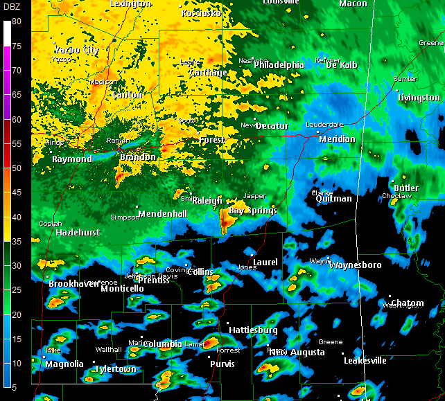
Early Morning Radar Look

((Note: You may click the thumbnail image for a larger version))
* A few things of interest on this radar image...The back edge of the line has become a bit broken...This could lead to a more supercellular mode of development, particularly across southernmost MS, where they didn't see as much stabilizing rain earlier tonight/yesterday...
* Strongest storm in our part of the world is moving through northern Lauderdale County...No warning on this storm, but could see some gusty winds in Collinsville, Martin, Bailey, and eventually Lauderdale and parts of southern Kemper County.
* Pretty impressive couplet on the storm in Marion/Lamar County...That one will stay south of our area, but it will be interesting to watch it develop. So far, there have been no reports of any tornadoes in Miss. I think the best chance of any actual tornado comes south of a line from McComb to Hattiesburg to Pensacola, FL.
* Now watching from home...Will drive back into work if the situation deteriorates, but Charles Daniel is on duty at the station and will handle the television side of things through the remainder of the morning...
2:30 AM Update
* My relief pitcher, morning meteorologist Charles Daniel, has arrived for duty...So, he'll be watching the radar closely and keeping you updated on TV through the rest of the morning. Be sure to tune into to Good Morning Meridian at 6:00 am for a full forecast as well.
* So far, so good - We haven't received any reports of any type of damage across our area. The main threat with this system will be flooding - we have received several inches of rain.
* A Flood Warning is in effect for the Pearl River above Philadelphia - it's expected to crest Thursday morning at 14.5 feet, or about 1.5 feet above flood level. At that point, water enters some of the campground at Lake Burnside Water Park.
* Please be safe driving to work this morning. Many roadways will still be wet, and there could also still be some ponding on roads. The best way to combat the threat of hydroplaning and accidents is to simply slow it down.
New Tornado Watch
* NWS/SPC has issued a new Tornado Watch. This one replaces the old watch. The new watch runs until 9:00 am - although our area will likely be trimmed from the watch well before 9:00 am. At this point, the watch includes all of our area.
* To be frank, I'm not completely sold on the prospect of tornadoes tonight. The atmosphere seems too stable, and instability is non-existent. However, there are some very strong winds just above the ground, so there is a threat of damaging wind within the stronger storms this morning.
* Going to do a live update on TV a little after 2 am...
12:55 AM Progress Report
* The line of storms continues to push on through central Mississippi. Right now the strongest core of thunderstorms from Starkville to Philadelphia to Collins (Covington County). While there are a few severe thunderstorm warnings along the line, none of them are in our area. And, the overall threat from these storms seems to be diminishing.
* This is a big-league rain event. Radar estimates that some parts of western MS saw close to 9". While an overestimate, it's still an impressive figure. Some places in the Delta have picked up over 4" of rain.
* The shield of rain is picking up speed a bit - with any luck we'll see mostly dry weather tomorrow.
New Mesoscale Discussion
* The Storm Prediction Center has issued a new Mesoscale Discussion for our area...Here are some highlights:
-- Greatest potential for damaging winds/tornadoes lies with the line of thunderstorms to our west, near the I-55 corridor
-- High levels of shear are overcoming marginal instability values to keep the threat of tornadoes going
-- Any tornado that does occur will likely do so as part of a linear complex
* Here's the complete discussion:
http://www.spc.noaa.gov/products/md/md2131.html
New Tornado Watch
* NWS has issued a Tornado Watch for almost all of our area...The new watch replaces the old one, and runs until 2:00 AM. Here are the counties in our viewing area that are part of the new watch:
MISSISSIPPI
Leake
Neshoba
Kemper
Scott
Newton
Lauderdale
Smith
Jasper
Clarke
Jones
Wayne
ALABAMA
Sumter
Greene
Hale
Marengo
Choctaw
Clarke
* REMINDER: A Tornado Watch means conditions are favorable for the development of tornadoes. The ingredients are there.
A Tornado WARNING means that a tornado has been either sighted or indicated on radar. If your county goes under a tornado warning, you should go to the lowest floor of your home. A basement works best; if you don't have one, go to an interior bathroom, hallway, or closet on your lowest floor.
Tornado Warning Scott and Smith
* NWS has issued a
Tornado Warning for Scott and Smith Counties until 6pm...
* This will affect westernmost Smith county, right along the county border...Then the western half or so of Scott County. Polkville, Pelahatchie, and Morton are all cities that could be impacted by this possible tornado.
* This potential tornado has been indicated on radar, not sighted. If you see severe weather in your neighborhood, please leave a comment on the weather blog.
345 PM Update
* Tornado Warning continues for Jasper County, although the circulation in that storm seemed to weaken a bit on the last radar scan...Would be surprised if NWS issues for Newton County based on that - but, should the next scan show rotation, they will issue...Stay tuned.
* Heavy rain falling across the northwestern half of the area. Hydroplaning will be a concern, so take it easy out there. Also, winds will be blowing pretty steadily - so high profile vehicles like trucks and RV's should exercise even more caution..
Tornado Warning Jasper County
http://kamala.cod.edu/offs/KJAN/0610162022.wfus54.htmlTornado Warning for Jasper County...Runs until 4pm...Possible tornado indicated on radar near Bay Springs...Take cover in lowest floor of your home - bathroom, hallway or closet...Basement works best if you have it.
Radar Update
* No current warnings right now...
* Heavy rain falling across Smith, Jasper, Scott, Newton, Leake, Neshoba counties...This rain shield is lifting northeast.
* Scattered thunderstorms cotninue to devleop farther south across parts of Jasper, Wayne, and Jones counties...
* BE careful if you're out driving this evening. In the event of heavy rain, slow down and be mindful of hydroplaning.
Tornado Warning Jones County
http://kamala.cod.edu/offs/KJAN/0610161955.wfus54.html* NWS has issued a Tornado Warning for Jones County...
* Storm is near Soso, moving north around 40mph. This storm will likely move along the Jasper/Smith County line.
Tornado Watch Issued
* A tornado watch has been issued for parts of our area...It includes these counties:
Lauderdale
Newton
Scott
Smith
Jasper
Clarke
Jones
* The watch runs until 9 pm.
* Tornado warnings have been issued for Simpson and Rankin Counties this afternoon...
Tornado Watch Possible

* Moderate to heavy rain continues to lift northward after dropping a soaking across most of the area...
* Atmosphere is trying to destabilize a bit, now that the rain is moving north...SPC considering a Tornado Watch:
http://www.spc.noaa.gov/products/md/md2125.html