Big Hail in Sumter County
* Receiving reports of golfball size hail in Sumter County. This occurred around 7:30pm...
* The same storm that brought the large hail to Sumter County is now moving south through Choctaw County...A severe thunderstorm warning continues for Choctaw county for about another 10 minutes...
* Other than that, the activity is beginning to show signs of weakening. The good news in all of this is the RAIN! Most places have picked up a tenth to a quarter of an inch. While not enough to completely make up the large deficit, every bit helps!
Severe Weather Update
* Severe thunderstorm warnings continue now for Leake, Neshoba, Newton, Lauderdale, Sumter (AL), and Choctaw (AL)...
* The line of storms is sinking southward...There is a big cluster of storms approaching the MS/AL state line, it is moving east, but developing new storms on the western edge of it. This cluster will likely merge with the storms moving out of Neshoba county.
* BIG THANKS to Emily Graham-Jacobs for going out and picking up dinner for me tonight...One of the first lessons I've learned in TV weather is that you are only as good as the people helping you. Thanks again!
* Back to watching the radar screen...
Severe Thunderstorm Watch...
* The SPC has placed most of our counties under a Severe Thunderstorm Watch until 11 pm tonight. The watch covers most of our area along and east of Highway 15 corridor. This includes the cities of Philadelphia, Newton, Bay Springs, Macon, De Kalb, Scooba, Meridian, Quitman, Livingston, York, Butler, and Demopolis. The main threat will be large hail and damaging winds. As far as timing goes, we are concerned about the general time from 5pm-11pm.
Here's the watch:
Severe Thunderstorm Watch* Radar lighting up over central Alabama, with more activity developing upstream over northern Mississippi. These storms are dropping towards the south/southeast, and will be the storms that affect us later.
Bugs and Better Rain Chances...
* One of my favorite hobbies is to take meandering drives down local back roads. Sunroof and windows down, Led Zeppelin in the CD player, and my worries are gone! I was out tonight in northern Lauderdale county, near Lake Okatibbee, and noticed the extreme number of insects in the air - and on my windshield! I could barely see the road at times. Believe it or not, the root cause of this is weather.
We did not have a particularly cold winter this year. Harshly cold temperatures tend to kill insects in their larva form, keeping them from ever hatching. But, without a terribly cold winter, there is little to keep the bug population from swelling.
Moral of the story? The next time its 6 degrees outside on a cold January morning and you forgot your gloves, your windshield is iced over, and you are already 10 minutes late; just smile and think to yourself: "At least I won't be drowning in mosquitoes in May!"
* Back to the here and the now: Looks like a pretty decent chance of showers and thunderstorms as we go through tomorrow afternoon. Some of these could be strong or severe, with large hail and damaging straight line winds the main threats. With decent instability and shear in place, we'll have to keep an eye on tomorrow. The flow of air aloft is from the northwest, and this type of setup can often offer up some interesting surprises.
* The weekend looks all right. A few clouds will hang with us for Saturday and Sunday, with highs in the 80's. The same upper trough bringing rain tomorrow will begin to slide back westward, so we have some rain chances in the forecast for Monday and again on Wednesday. The forecast for next week is murky at best.
First Tropical Storm Forms...
* The first tropical storm of the 2005 season has formed in the Pacific Ocean...It's named Adrian. Here's the skinny on Adrian from the National Hurricane Center:
http://www.nhc.noaa.gov/text/refresh/MIATCPEP1+shtml/180227.shtml* Time to get some rest...
Busy Day...
* I had a GREAT time visiting with my friends at T.J. Harris Elementary School in Meridian this morning. We had a really wonderful time, and I was fortunate enough to hear their MCT rap - a song they perform about a standardized test they must take.
* After that, the afternoon was pretty quiet. Our weather today was pretty simple - mostly sunny and warm. We'll see more of the same tomorrow and Thursday, but we will be a few degrees warmer. Highs either afternoon could conceivably reach 90 degrees, especially along and south of Interstate 20.
* It's been really interesting reading the chase accounts from Renny Vandewege of MSU and other groups out on the Plains. Thanks to everyone who has participated in getting the word out about what our local universities are doing in Tornado Alley!
* A quick note: The National Weather Service will be conducting several tests with their flood watches and warnings tomorrow. So, if you receive a statement saying a flood watch or warning has been issued, it's a test. In fact, we are much closer to a drought than a flood - Meridian has managed only 0.02" of rain so far this month. That is close to 3 inches below normal.
* Speaking of rain: We'll probably get some late Friday afternoon into Friday night. A deep upper low will cutoff northwest of here, and lobes of energy called shortwaves will rotate around it. These shortwaves often cause rising air - which interacts with moisture to create rain. We'll probably see some rain late Friday, with lingering showers and perhaps a thunderstorm through Saturday. Rain chances begin to diminish by Sunday and into early next week.
Official Hurricane Forecast
* The government has issued their forecast for the 2005 hurricane season, and they are looking for a very active year. Here's an excerpt from an e-mail I received today from Gary Beeler, the Warning Coordination Meteorologist at the National Weather Service in Mobile:
NOAA (National Oceanic and Atmospheric Administration) released their forecast of the upcoming hurricane season for this year today at Stennis International Airport.
NOAA's
numbers...
12-15 named storms (Average is 9-10)
7-9 hurricanes (Average is 5-6)
3-5 major hurricanes -Cat 3 or higher- (Average is 2-3)
Sunday Update
* Beautiful storm chase photos from the crew in the Great Plains! Hope that they see some more active weather before heading back home.
* Our weather will be picture perfect for the first few days of the week. Expect slightly cooler and drier than normal weather until about Wednesday, when we should start to see things warm up.
* The forecast for later next week is very difficult. Lots of disagreement among the models about rain chances. I mentioned the possibility of rain Thursday night and then again Friday night into Saturday. I'm sure this will change many times between now and then, but one thing remains true... the fact that we need the rain! Already almost 3 inches below normal for the month of May.
* Enjoy a beautiful start to the work week, and I will enjoy a beautiful drive back to my home of Rainbow City, Alabama tomorrow. One of my good friend's sisters (and also a good friend of mine) is graduating from high school, and we are planning a big cookout. Also, I won tickets to see the new "Star Wars" movie on a midnight showing Wednesday night / Thursday morning. Very excited about that!
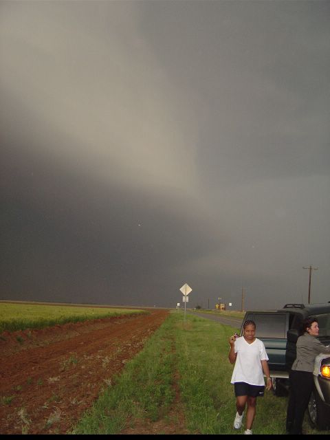
Storm Chase Pictures
Here are some pictures from Mississippi State's Storm Chase, courtesy of Dr. Mike Brown:
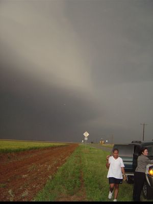
Beautiful storm!

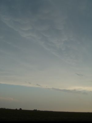
The circular clouds you see are called mammatus clouds, and are indicative of atmospheric turbulence.
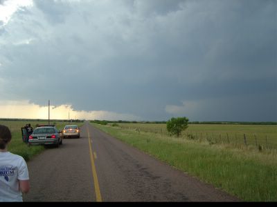
Chasers check out a wall cloud!