Sleet?!
*If you saw small ice pellets hitting your car, your eyes were not tricking you. A few showers were touched off by a shortwave this afternoon. Sleet fell within some of these showers. Seems odd to have sleet falling when the temperature is well above freezing (upper 40s), but it is certainly possible.
*Today we had extremelly dry air in the lower and mid levels of the atmosphere. As precipitation fell, much if it evaporated. As water evaporates, it uses heat energy in doing so, thus cooling the surrounding air around it (known as evaporative cooling). The air was cool enough to freeze remaining water droplets into ice pellets, which fell to the ground as sleet.
*Sunday looks to be a warmer day in the 60s with a mix of sun and clouds. A strong upper level low works in Sunday night, bringing a high chance of rain. Models are hinting at nearly an inch of rain falling between Sunday night and Monday night. Thankfully this will fall as a slow, steady rain which will soak into the ground! If this were January, this would be a good set up for a few snow flakes, but the atmosphere doesn't look quite cold enough yet!
*Early indications are that your Thanksgiving holiday will be partly cloudy with temperatures in the low 60s and a slight chance of an afternoon shower!
Fire Concerns
* What a rash of house fires over the last 24 to 36 hours. We generally see this with the first really cold blast of the year, and it's unfortunate. We don't want you or your family to be at risk; here is a checklist of fire prevention and safety tips:
- Develop a fire escape plan for your family that identifies two exits out of every room and an established meeting place outside. Practice makes perfect – hold a family fire drill at least twice each year.
- Install smoke alarms on every level of your home and test them monthly. The Home Safety Council recommends installing additional smoke alarms inside bedrooms.
- Know how to extinguish a small pan fire by sliding a lid over the flames.
- Teach every family member to “Stop, Drop and Roll” if clothes catch fire.
- Consider having a home fire sprinkler system installed in your new home, or when you remodel.
- Learn how and when to use a fire extinguisher.
- Always use stable, candle holders made of material that won’t catch fire, such as metal, glass, etc.
- Schedule an appointment with professionals to have chimneys, fireplaces, wood and coal stoves, central furnaces and space heaters inspected once a year and cleaned as often as necessary.
- Keep space heaters at least three feet away from things that can burn, such as curtains or stacks of newspaper, and always turn off heaters when leaving the room or going to bed.
- Be careful not to overload electrical outlets, extension cords and power strips.
- Check all wires and cords for damage and cover all unused electrical outlets.
- Protect bedrooms by having arc fault circuit interrupters (AFCIs) installed. Contact a professional electrician to handle this job.
* These tips are courtesy of
www.homesafetycouncil.org* BIG changes to our forecast...Computer model guidance now suggesting the possibility of some rain as early as late Sunday. The best chance of rain seemingly comes Monday, as a deep upper low moves across the deep South.
* Heading to Auburn, Alabama tonight after the 10pm newscast...I hope your favorite team is successful this weekend!
Forecast Bust
* I notice that the low this morning out at Key Field was much warmer than our forecast. The reason: the wind didn't quit blowing. When the wind blows all night like that, it keeps the air near the earth's surface well-mixed. This keeps the coldest air from settling to the Earth's surface.
* We should see calm winds tonight, which will allow temperatures to fall down into the middle 20's. A hard freeze is on tap. Bring those sensitive plants indoors - and you might want to keep them indoors for the next several nights.
* Cool and dry are the key words to remember. We may see 60 on Saturday, but a reinforcing shot of cool air will arrive by the latter part of the weekend. Enjoy your weekend!
Severe Weather Threat Ends
* The threat of severe weather has ended, and much colder air has swept into much of our area. Meridian's Key Field is down to 55 degrees. I also note that Key Field saw a 15 degree temperature drop in 2 hours - pretty quick!
* Today still looks rather chilly. I'll be interested to see how our cloud cover works out. Forecasting cloud cover in a strong cold advection situation is one of the most troublesome challenges in our field. My feeling is that we do see plenty of stratus clouds early, followed by some gradual clearing late in the day. Obviously, any big changes to the cloud forecast would result in some changes to our temperature forecast. We'll stick with the gradual clearing idea and temperatures in the lower 50's.
* Very cold weather for tonight and tomorrow night. A hard freeze is likely across our entire area on both nights. In fact, the new NGM MOS spits out a low of 22 for Meridian Friday morning! BRRRR.
Things Winding Down..
* As the line of thunderstorms continues to move east, things are winding down a bit. There are still some strong thunderstorms out there, mainly along and south of I-59. But, at this time, none of those are severe. However, if you live along and south of I-59, we don't need to let our guard down just yet.
* The main threat with any storms from here on out will be damaging thunderstorm winds. There is a small chance of an isolated tornado or two. We'll continue to monitor things.
* For places like Newton, Forest, Philadelphia, Bay Springs, Macon, Meridian, Raleigh and Carthage - the threat of severe weather has ended.
* We'll keep watching the radar...
Tornado Warning -- Smith County
Tornado Warning has been issued for Smith County until 9:30 pm...


BULLETIN - EAS ACTIVATION REQUESTED
TORNADO WARNING
NATIONAL WEATHER SERVICE JACKSON MS
841 PM CST TUE NOV 15 2005

THE NATIONAL WEATHER SERVICE IN JACKSON HAS ISSUED A

* TORNADO WARNING FOR...
SOUTHERN SMITH COUNTY IN CENTRAL MISSISSIPPI
EASTERN COVINGTON COUNTY IN SOUTHEAST MISSISSIPPI
THIS INCLUDES THE CITY OF COLLINS

* UNTIL 930 PM CST

* AT 841 PM CST...NATIONAL WEATHER SERVICE DOPPLER RADAR INDICATED A
SEVERE THUNDERSTORM CAPABLE OF PRODUCING A TORNADO 7 MILES WEST OF
COLLINS...MOVING NORTHEAST AT 50 MPH.

* THE TORNADO IS EXPECTED TO BE NEAR...
TAYLORSVILLE BY 855 PM CST

SEEK SHELTER ON THE LOWEST FLOOR OF THE BUILDING IN AN INTERIOR
HALLWAY OR ROOM SUCH AS A CLOSET. USE BLANKETS OR PILLOWS TO COVER
YOUR BODY AND ALWAYS STAY AWAY FROM WINDOWS.

IF IN MOBILE HOMES OR VEHICLES...EVACUATE THEM AND GET INSIDE A
SUBSTANTIAL SHELTER. IF NO SHELTER IS AVAILABLE...LIE FLAT IN THE
NEAREST DITCH OR OTHER LOW SPOT AND COVER YOUR HEAD WITH YOUR HANDS.
Severe Thunderstorm Warning -- Smith County
BULLETIN - EAS ACTIVATION REQUESTED
SEVERE THUNDERSTORM WARNING
NATIONAL WEATHER SERVICE JACKSON MS
833 PM CST TUE NOV 15 2005
THE NATIONAL WEATHER SERVICE IN JACKSON HAS ISSUED A
* SEVERE THUNDERSTORM WARNING FOR...
SOUTHERN SMITH COUNTY IN CENTRAL MISSISSIPPI
* UNTIL 930 PM CST
* AT 833 PM CST...NATIONAL WEATHER SERVICE DOPPLER RADAR INDICATED
A SEVERE THUNDERSTORM CAPABLE OF PRODUCING DAMAGING WINDS IN
EXCESS OF 60 MPH...LOCATED 12 MILES WEST OF TAYLORSVILLE MOVING
NORTHEAST AT 45 MPH.
* THE SEVERE THUNDERSTORM WILL BE NEAR...
TAYLORSVILLE BY 845 PM CST
A TORNADO WATCH REMAINS IN EFFECT FOR THE WARNED AREA. SEVERE
THUNDERSTORMS CAN PRODUCE TORNADOES WITH LITTLE OR NO WARNING. IF A
TORNADO IS SPOTTED...ACT QUICKLY AND MOVE TO A PLACE OF SAFETY IN A
STURDY STRUCTURE...SUCH AS A SMALL INTERIOR ROOM.
LAT...LON 3193 8966 3179 8965 3181 8932 3207 8934
Severe Thunderstorm Warning -- Pickens County
BULLETIN - EAS ACTIVATION REQUESTED
SEVERE THUNDERSTORM WARNING
NATIONAL WEATHER SERVICE BIRMINGHAM AL
820 PM CST TUE NOV 15 2005
THE NATIONAL WEATHER SERVICE IN BIRMINGHAM HAS ISSUED A
* SEVERE THUNDERSTORM WARNING FOR...
PICKENS COUNTY IN WEST CENTRAL ALABAMA
THIS INCLUDES THE AREA OF ALICEVILLE
* UNTIL 915 PM CST
* AT 820 PM CST...NATIONAL WEATHER SERVICE DOPPLER RADAR INDICATED A
SEVERE THUNDERSTORM CAPABLE OF PRODUCING DAMAGING WINDS 60 TO 75
MPH...WHICH CAN KNOCK DOWN LIMBS AND POWER LINES...DAMAGE WEAK
STRUCTURES...AND PUSH TRUCKS OFF THE HIGHWAY. THIS STORM WAS
LOCATED NEAR COCHRANE...OR ABOUT NEAR ALICEVILLE...AND MOVING
NORTHEAST AT 40 MPH.
* OTHER LOCATIONS IN THE WARNING INCLUDE BUT ARE NOT LIMITED TO
ALICEVILLE...CARROLLTON...REFORM AND GORDO.
A TORNADO WATCH REMAINS IN EFFECT FOR THE WARNED AREA. IF A TORNADO
IS SPOTTED...ACT QUICKLY AND MOVE TO A PLACE OF SAFETY IN A STURDY
STRUCTURE...SUCH AS A BASEMENT OR SMALL INTERIOR ROOM.
TO REPORT SEVERE WEATHER...
CALL 1-800-856-0758.
Storms on the Move
* Thunderstorms are moving through the area - but the threat of severe weather seems to be decreasing. The supercells that were previously out in front of the line have been overtaken by the line. This squall line sure looks like it will clear out of here before midnight...We'll continue to hold up the guard until the line is clear, but again, the threat of severe weather seems to be decreasing.
* The storms are moving through Newton County right now. Our friend Ron Davis of the City of Newton reports frequent lightning and gusty winds - but nothing severe.
* Get ready for a big cooldown. Temperatures the next few days will be much colder...Highs in the 50's, lows in the 20's!
Severe Thunderstorm Warning -- Scott County
* Severe Thunderstorm Warning for Scott County until 7:45pm...
THE NATIONAL WEATHER SERVICE IN JACKSON HAS ISSUED A
* SEVERE THUNDERSTORM WARNING FOR...
EASTERN SCOTT COUNTY IN CENTRAL MISSISSIPPI
THIS INCLUDES THE CITY OF FOREST
* UNTIL 745 PM CST
* AT 709 PM CST...NATIONAL WEATHER SERVICE DOPPLER RADAR INDICATED A
SEVERE THUNDERSTORM CAPABLE OF PRODUCING NICKEL SIZE HAIL...AND
DESTRUCTIVE WINDS IN EXCESS OF 70 MPH. THIS STORM WAS LOCATED 9
MILES NORTHWEST OF FOREST...AND MOVING NORTHEAST AT 40 MPH.
* THE SEVERE THUNDERSTORM WILL BE NEAR...
HARPERVILLE BY 715 PM CST
SEBASTOPOL BY 730 PM CST
A TORNADO WATCH REMAINS IN EFFECT FOR THE WARNED AREA. SEVERE
THUNDERSTORMS CAN PRODUCE TORNADOES WITH LITTLE OR NO WARNING. IF A
TORNADO IS SPOTTED...ACT QUICKLY AND MOVE TO A PLACE OF SAFETY IN A
STURDY STRUCTURE...SUCH AS A SMALL INTERIOR ROOM.
New Watch Forthcoming
* The SPC will soon be issuing a tornado watch for most, if not all, of our area. Here's their latest update on the watch..
http://www.spc.noaa.gov/products/md/md2436.html
Tornado Warning
* Tornado warning for Hinds County...
MSC049-152300-
/O.NEW.KJAN.TO.W.0331.051115T2208Z-051115T2300Z/
BULLETIN - EAS ACTIVATION REQUESTED
TORNADO WARNING
NATIONAL WEATHER SERVICE JACKSON MS
408 PM CST TUE NOV 15 2005
THE NATIONAL WEATHER SERVICE IN JACKSON HAS ISSUED A
* TORNADO WARNING FOR...
NORTHERN HINDS COUNTY IN CENTRAL MISSISSIPPI
THIS INCLUDES THE CITY OF CLINTON
* UNTIL 500 PM CST
* AT 408 PM CST...NATIONAL WEATHER SERVICE DOPPLER RADAR INDICATED A
SEVERE THUNDERSTORM CAPABLE OF PRODUCING A TORNADO NEAR EDWARDS...
OR ABOUT 14 MILES EAST OF VICKSBURG...MOVING NORTHEAST AT 35 MPH.
* THE TORNADO IS EXPECTED TO BE NEAR...
I-20 EXIT 27 BOLTON AND BOLTON BY 420 PM CST
9 MILES NORTHWEST OF CLINTON BY 430 PM CST
IN ADDITION TO THE TORNADO...THIS STORM IS CAPABLE OF PRODUCING
NICKEL SIZE HAIL AND DESTRUCTIVE STRAIGHT LINE WINDS.
SEEK SHELTER ON THE LOWEST FLOOR OF THE BUILDING IN AN INTERIOR
HALLWAY OR ROOM SUCH AS A CLOSET. USE BLANKETS OR PILLOWS TO COVER
YOUR BODY AND ALWAYS STAY AWAY FROM WINDOWS.
IF IN MOBILE HOMES OR VEHICLES...EVACUATE THEM AND GET INSIDE A
SUBSTANTIAL SHELTER. IF NO SHELTER IS AVAILABLE...LIE FLAT IN THE
NEAREST DITCH OR OTHER LOW SPOT AND COVER YOUR HEAD WITH YOUR HANDS.
Afternoon Update
* We are watching supercells forming out in western Mississippi. These seem to be forming into multicellular clusters out ahead of the squall line. But, the threat of tornadoes will continue as long as these supercells can stay independent of the line.
* Our expectation is that the individual cells will be overtaken by the line and they will merge with the squall line later this evening. Then, this squall line will race from west to east across the area. Some damaging winds are possible, along with the threat of tornadoes. While the largest chance of a significant tornado outbreak remain north of here, we must remain aware and prepared for the possibility of severe weather tonight across Mississippi and west Alabama.
* MUCH colder air will come in late tonight into tomorrow. Temperatures tomorrow will likely stay steady in the lower 50's, with a stiff northerly breeze making it feel much colder. The chilly air will hang around; temperatures Thursday and Friday morning will likely fall into the middle 20's. This will be our first widespread hard freeze of the year, so if you have agricultural interests, be sure to take any action necessary to your specific operation.
Update from NWS Jackson
* Here's an excerpt from our Instant Messaging conference with NWS Jackson. Typing this is Jeff Craven, one of the brightest severe weather minds in the country. It's a discussion of positives and negatives about the severe weather potential:
NEGATIVES:
*Empirically, the 500 mb heights are pretty high. 18z was 583 dm at KJAN. Normally, to be in the core of the worst weather, we are in the 570 to 576 range.
*Surface pressures are rather high...currently around 1014 mb. Typically we are less than 1008 mb and it becomes quite favorable less than 1004 mb.
*500 mb temperature was -9. Our worst events are -12C or colder. However, we had values around -10 C for November 10th 2002, so this is only marginally weak on the parameter scale.
*Surface low is already moving into IL, which is pretty far north of us. The best pressure falls extend from MEM/TUP on north.
*500 mb winds are about 35 knots...though they are forecast to strengthen. We typically like to see 50-60 knots in the bigger severe weather events.
POSITIVES:
*0-1 km shear is running 25-30 knots...suggesting chance of strong tornadoes
*Sun was out today, so we have pretty high values of CAPE. 18z sounding from LCH had MLCAPE of 3000 j/kg, which is really high, with about 1500 j/kg at SHV.
*On water vapor...there seems to be a southern branch short wave trough moving northeastward from the TX coast toward our area.
*Showers and thunderstorms that developed ahead of cold front from Houston area toward west central MS have cellular character...which could evolve into supercells with somewhat higher chances for tornadoes.
*Overall pattern suggests that the worst threat for extreme damaging winds and tornadoes will be from Memphis County Warning area on north. We think that the high risk is too far south. Moderate risk seems a bit generous as well.
*I think we will see a few tornadoes and quite a few reports of damaging winds, especially along the cold front with the developing squall line. Just don't think this event, for Jackson County Warning Area, will be as big as some of the events we've seen in the past few years.

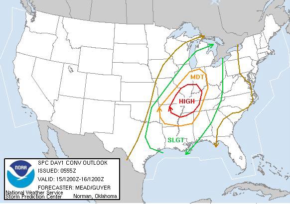
The Moderate Risk has been shifted further south, and now includes much of our area. The threat of severe weather exists today, please stay close to a good source of weather information! I will have another update later this morning.


The 6z (midnight) outlook from the Storm Prediction Center has our area in a Slight Risk for Severe Thunderstorms, which is consistent with our thinking. This means we can expect a few storms to be severe, with damaging winds the primary threat. However, we cannot rule out a few tornadoes, especially along and north of Mississippi Highway 14. Further north, parts of Arkansas, Tennessee, Missouri, Illinois, Indiana, and Kentucky are in a HIGH risk - we expect a significant outbreak of tornadoes and severe weather up there later today and tonight.
Late Night Update...
* 0z model guidance continues to suggest the possibility of severe weather tomorrow. Here's our latest thinking...
...We expect supercells to form across northern and western Mississippi tomorrow afternoon...
...Some of these supercells will move/develop towards our area. These supercells do have the threat of producing tornadoes, especially along and north of I-20 (and even more so along and north of Miss. Hwy 14...
...By tomorrow evening, the supercells will merge into a squall line, which will race from west to east across MS and AL. This line will provide a threat of damaging winds, and there could be an isolated tornado or two within the line...
...The squall line will rush through, and our winds will shift around to the northwest. Much cooler air will stream in by tomorrow morning, and tomorrow will see highs only making it into the 50's...
* I will post another update after the 6z (midnight) update from the Storm Prediction Center...
* We are continuing to evaluate the latest (18z - noon) computer model guidance for the threat of severe weather beginning late tonight and lasting through the day Tuesday and into Tuesday night.
* While there is certainly a threat of severe weather, the WORST of the weather should stay north of here, where the more favorable upper-level dynamics exist. I spent some time this afternoon doing some research on late season severe weather events. In almost each of the November severe weather episodes of the last several years, there have been very strong wind fields aloft. That belt of strongest winds is forecast to be from Missouri to Michigan, which would indicate that the worst of the severe weather threat should stay there.
* However, there is enough instability forecast to bring a round of showers and thunderstorms through here tomorrow. Any supercells that form should do so in the afternoon hours, followed by a strong line of thunderstorms tomorrow night. The main threat will come in the form of damaging winds, but directional shear values suggest that there could be a few tornadoes.
* This is one of those "borderline" events that really give us weather forecasters fits. While the instability and directional shear seem sufficient for severe weather, the speed shear in the atmosphere seems to be lacking.
* BUT...We all know how quickly these things can change.
And, again, I'd like to reiterate that NOW is the time to check the batteries in your NOAA weather radio. Also, if you do not own a NOAA weather radio, now is the time to buy one. They are available as a fairly inexpensive purchase at any consumer electronics store.* I will post again this evening after the 0z (6pm) model guidance comes in, sometime between 10-11pm.
Severe Weather Possible Late Tomorrow...
* Things seem to be coming together for a severe weather event late tomorrow into tomorrow night across much of our area. The latest computer model guidance has more than adequate instability and shear. Here are the latest numbers from the NAM model for , valid 6pm tomorrow:
CAPE: 1247.1 J/kg
LI: -3.7
0-3 KM SRH: 268.9
These numbers suggest the distinct possibility of a severe weather event, mainly along and north of Interstate 20...
***NOW is the time to check the batteries in your NOAA weather radio. If you do not have a NOAA weather radio, they are available for purchase at any consumer electronics store.***
* The Storm Prediction Center has placed roughly the northern half of our viewing area under a Moderate Risk for severe weather...
SPC Day 2 Outlook* Off to run a few errands, will have another update early this afternoon.
Rain and Storms
* Just getting my computer back online. My laptop decided to flake out on me this weekend, and I've been trying to get all of my programs and things back in line...We have a LOT of weather on the plate, so I'll try to hit the highlights over the next week or so.
* It sure looks like we are going to get some beneficial rain during the next 48 hours. The extracted output from the NAM forecasts 0.90" of rain between now and midnight Tuesday night - hopefully we can get that much.
* It's also worth noting that the NAM brings our CAPE (instability) up over 800 J/kg, with a negative LI - both of these indicate atmospheric instability and the potential for thunderstorms - some of these could be strong or severe. But, it really seems that the best upper level dynamics will be north of here. Be sure to scroll down for a great discussion by Renny Vandewege regarding the forecast - a very in-depth look at what we're expecting. Here's a great basic primer on some of the severe weather indices that Renny used:
http://www.e-falk.com/wx/thunderstorms.php* MUCH cooler air will arrive by Wednesday. Highs will likely stay in the upper 50's and lower 60's through the weekend. The cool shot will not be extremely chilly, but should keep us near seasonable temperatures.