10:00 PM SAT Katrina Update
Newest numbers in from the NHC:
Position: 25.0 N 86. 2 W (335 miles southeast of the mouth of the Mississippi River)
Winds: 115 mph
Gusts: 140 mph
Movement: WNW 7 mph
Latest Satellite imagery suggests that Katrina has a closed eye, which we may be able to see more clearly soon. It underwent several eyewall replacements today, but appears to have one dominant eye wall which is about 45 miles wide. We do anticipate instensification overnight. This is moving into the warmest waters and should pick up speed as it makes its way towards the coast. Coming up a little later I will post some things to do in order to be prepared for this hurricane!
Coverage Planning...
..Today has been a busy day, filled to the brim with planning. Since we are understaffed right now, WJHG (a sister Gray station in Panama City) has sent us their chief meteorologist, Jason Kelley. Jason has years of experience along the Gulf Coast, and will assuredly be a major asset in our coverage of the storm. He is also an Alabama native, so he knows the area very well..
..Thanks to Baron Services, we will be using some great equipment for our coverage. By late Sunday, we'll roll out a new look radar system brought here for coverage of Katrina! Be sure to check it out..
..We are also going to have a satellite truck and additional reporter from our sister station in Dothan, Alabama. This will allow us to bring you live shots of the storm from almost anywhere in the area. This will help us to show you exactly what the storm is doing in our community..
..Planning our coverage for Hurricane Katrina continues this evening. There will probably be changes fast and furious, and we'll just roll with the punches. Here's the current plan, dependent of course on how the weather changes.
SUNDAY:
I will be doing live cut-ins during Good Morning America, beginning at 7:00 AM and lasting one hour.
We will then begin hourly Katrina updates around noon. These will continue through Sunday evening and into Sunday night.
We will have a special half-hour newscast Sunday evening at 5:30. This will be a complete look at Katrina and how the storm is affecting Mississippi, Alabama, and other coastal areas. Preparedness information will be emphasized, so don't miss it!
Newscenter 11 News at 10 will be heavily geared towards the hurricane. After the news concludes, we will be doing hourly updates on the progress of the storm all night Sunday night.
MONDAY and TUESDAY:
Good Morning Meridian will be an hour of information about the hurricane. Preparedness information, storm updates, and information about coastal areas will all be discussed - among other things.
We will continue our hourly updates throughout Monday, and will eventually begin "wall to wall" coverage of Katrina when conditions warrant. This will likely come sometime Monday evening, but that is subject to change as conditions dictate.
We will stay "wall to wall" (no programming, only weather and news about Hurricane Katrina) throughout the duration of the storm. We will wrap up our coverage sometime Tuesday, whenever the storm has passed.
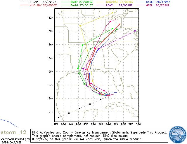
..While we hope for the best, we have planned for the worst. Your preparations should be finished in the near future. The storm is speeding up a bit, and we could begin seeing some spiral banding as early as late Sunday afternoon or evening. The worst of it will arrive during the afternoon and evening hours Monday. Renny Vandewege will be along shortly to post an update on the specifics of the 10 pm update from the National Hurricane Center..
4:00 PM Saturday Katrina Update
* Latest numbers and forecast track in from the NHC:
* Winds: 115 mph, gusts to 145 mph
Location: 24.6 N 85.6 W
* The newest track takes it inland south of New Orleans as a strong Category 4 hurricane with maximum sustained winds of 145 mph with gusts much higher. Form there it would most likely make landfall again along the Mississippi Coast and proceed north and east through Mississippi.
* This scenario would bring destructive winds and very heavy amounts of rain to the area. The potential exists for widespread and lengthy power outages as well as flooding.
* Landfall is forecast to occur sometime Monday morning, with the worst of it around here coming during Monday and into Monday night and early Tuesday morning. The timing will also likely be adjusted as we get closer to landfall..
* As we have mentioned earlier, if the current forecast verifies, east Mississippi and West Alabama would be on the dangerous east side of the hurricane center where tornadoes within the hurricane are most commonly found.
* We are watching this very closely and refining our forecast as more information becomes available and updated. Please keep checking the blog, as well as previous blog enteries and also check out our newscasts for further updates!
Mid-Morning Update
* Online conferencing continuing this morning...New data continuing to roll in from the 12z model runs...Thinking hasn't changed much:
..Katrina will make landfall somewhere between Morgan City, Louisiana and Mobile, Alabama. The most likely position seems to be southeastern Louisiana. From there, it will move inland, bringing destructive winds and heavy rains to much of our area. The potential exists for widespread and lengthy power outages.
..Our confidence is growing that this will be a very significant event for east Mississippi and west Alabama - possibly on the same scale as what Ivan brought to our area. Please prepare today for power outages - have plenty of water, batteries, flashlights, and non-perishable food items at hand..
..10am update from NHC will not change the track much, perhaps a slight shift to the east once inland. They bring the center in over New Orleans and then northward to near Kosciusko..At that point, the storm is forecast to have sustained winds near 70mph and gusts to near 90 mph. There is still plenty of uncertainty, but things are starting to point to a LA/MS direct hit..
..Landfall is forecast to occur sometime Monday morning, with the worst of it around here coming during Monday and into Monday night and early Tuesday morning. The timing will also likely be adjusted as we get closer to landfall..
..If the NHC track verifies, almost all of east Mississippi and west Alabama will be on the dangerous eastern side of the storm. The eastern side brings the worst wind and often is accompanied by tornadoes..
..While nothing is written in stone yet, I want to emphasize that this has the potential to bring life-threatening weather to much of our area. Please continue to prepare today and tomorrow..
Katrina a Major Hurricane
..Katrina has been upgraded to a Category 3 hurricane. I'm afraid that Category 4 status is not far behind..
..Forecast track has been shifted very slightly to the west, bringing the center inland in southeastern Louisiana early Monday afternoon and then moving Katrina to near Jackson by early Tuesday morning. This would put our area in the eastern side of the hurricane. Too early to get specific, this track will likely bounce around some more. We will try to pinpoint threat areas later today or tomorrow when we have more confidence in the track..
..Prepare now for the possibility of extended power outages and wind damage across central Mississippi and west Alabama. Right now, the threat of these outages includes all of our area. Again, we will try to narrow down the threat to specific parts of our area in the next day or so. Obviously, the further south you are, the higher your potential for damage..
..Very apprehensive about the potential catastrophe unfolding for New Orleans. Barring a major shift in track, the Crescent City will be facing a terrible and life-threatening situation. Any of your family and friends who live in New Orleans should evacuate immediately..
..STAY UPDATED..That's the best advice on the table. Check back here, and also check our
Hurricane Katrina Info Desk for plenty of information..
..Here are some preparation tips for inland areas, courtesy of the National Hurricane Center. Some of this information is geared towards coastal areas, but plenty of it applies to us here as well:
http://www.nhc.noaa.gov/HAW2/english/disaster_prevention.shtml
Computer model guidance...Clustering between Morgan City and Pascagoula.

9:30pm Update
* Finishing up coordination conferences with various weather entities...The National Hurricane Center (NHC) is wrapping up the finishing touches on their 10pm CDT forecast package. Here are some highlights...
..NHC will shift track slightly west of their current track they will have it making landfall somewhere near Biloxi..
..HPC (Hydrometeorological Prediction Center) has shifted even further west, with landfall along the central Louisiana coastline..
..Intensity seems sure to skyrocket over the next 24 hours..NHC has Katrina as a Category 4 hurricane at landfall - this would be a very significant event..
..UNCERTAINTY in forecast track is at an all-time high..Model data seems to be clustering in Louisiana, but others take it anywhere from Florida to Mexico..
..Preparations should begin as soon as possible for potential power outages and wind damage across central Mississippi and Alabama..Impossible to pinpoint the area of maximum threat until we get a better handle on where landfall will occur..But, we must prepare for the worst while hoping for the best..
Katrina Roaring Along...
* Running short on time, so this will have to be pretty quick..
..Model guidance continues a westward shift. Threat increasing for our area---too early to pinpoint exactly where the largest threat is.
..Our best guess at landfall is somewhere between Biloxi and Pensacola, but there are indications it could be further west than that. Anywhere between Morgan City, Louisiana and Apalachicola, Florida should rush preparations to completion.
..I want to emphasize that Katrina will very likely become a major hurricane, possibly even a Category 4 storm. This is a dangerous situation, particularly along the immediate coastline. However, there is a substantial threat for wind damage for much of Mississippi and Alabama - especially along and east of the eventual track of Katrina.
..This is a VERY difficult storm to forecast. Steering currents are weak, and this storm has a history of moving erratically. Buckle up, there will be some fast curves - hour to hour surprises will be the norm over the next 72 hours.
..Will update later tonight...
Katrina Update
* Still watching Tropical Storm Katrina this afternoon. Katrina is just off the Florida coastline, and will make landfall along the southernmost tip of Florida later tonight. There is some chance it will strengthen into a hurricane before making landfall down there.
* After making landfall there, it will likely move west, emerging out over the Gulf of Mexico. It will move towards the northwest and eventually turn to the north. This will bring Katrina towards the northern Gulf Coast. While the most likely landfall point is east of here, it is simply too early to give an "all clear" yet. This is a slow moving storm embedded in weak steering currents - these type storms are notoriously difficult to nail a good track forecast. Everyone between New Orleans and Tampa should continue to watch this closely.
* The computer model guidance is all over the place. There is a group of models that brings Katrina in along the Alabama/Florida border and then moves it into central Alabama. Another group brings Katrina onshore along the Big Bend area of Florida.
* Right now, it appears that the worst of Katrina will pass to our east. But, that's far from being written in stone at this point. We'll continue to check out the latest information and will keep you updated here and on television tonight at 5, 6, and 10!
Katrina Forms...
* After a lull in the action, it appears that the tropics are becoming much more active. Tropical Storm Katrina formed this morning near the Bahamas, as a recon flight found winds near 40mph.
* Where will Katrina go? Tough question. There is a great deal of spread in the dizzying array of model solutions. But, the consensus seems to hint at a track over the southern Florida peninsula and eventually into the eastern Gulf of Mexico. From there, it may curve north and move back into Florida. Or, it could move more northwest towards the northern Gulf Coast. Simply too early to tell. The bottom line is that everyone between Houston and Miami will have to watch this one. Hurricane preparations could begin by Friday, with landfall possible as early as Sunday.
* How strong will Katrina get? Indications are that Katrina will undergo some modest strengthening before its' first landfall along the Florida coast. It could even become a hurricane; water temperatures down there are very warm! As far as strength goes once it enters the Gulf, a lot depends on how well the circulation stays intact after moving over Florida. If the circulation manages to stay mostly intact, the environment in the Gulf is quite favorable for strengthening. Water temperatures down there are VERY warm.
* The bottom line is that it is very early in the game, but Katrina has the potential to impact anyone along the Florida, Alabama, Mississippi, and Louisiana coastline. We'll be watching closely in coming days...
Tropics Heating Up
* Tropical Depression 12 has formed in the Bahamas...This system has good potential to become a Tropical Storm and eventually a hurricane, depending on how it interacts with the Florida peninsula.
* The model forecast tracks show great variability. One group of models wants to curve the storm along the East Coast...While another group takes the system across the Florida peninsula and into the southeastern Gulf of Mexico. We believe that the latter is the more likely of the two solutions.
* WAY too early to pinpoint an area of threat. But, anywhere between Miami and Houston should watch this system closely. We'll certainly keep an eye on things...
* I'll post again tonight when the 10pm CDT update from the National Hurricane Center is available...
Noxubee County Severe T-Storm Warning
* Severe Thunderstorm Warning for Kemper County...Warning goes until 6:15pm
* Storm is dropping south...Will probably have some small hail, gusty winds and a LOT of lightning....Storm will drop southward along Hwy 45, affecting much of Noxubee County and eventually Kemper county.
Winston County Storm
* NWS has issued a Severe Thunderstorm Warning for Winston County...
* This warning is in effect until 5:15pm and will affect mainly western parts of the county...Along and west of Mississippi Highway 25.
* Gusty winds, small hail and frequent lightning will accompany the worst parts of this cell as it moves southward through western Winston County. Stay inside until the storm has passed, and stay off of wired telephones - they can allow electricity from lightning to harm you.
* Most of the activity has been across northern Mississippi and central Alabama today...The radar is busy as a bee today.
* We'll watch it...
Noxubee/Kemper Warning
Severe Thunderstorm Warning for Noxubee and Kemper counties until 8:00pm. This was located near Gholson and sloooowly drifting south. As of 7:15 it appeard to weaken just slightly, but this is still a dangerous storm.
Nickel Sized hail, gusty winds to 60 mph and very heavy rain can be expected.
Watching closely...
Severe T-Storm Warning
* Severe thunderstorm warning for Scott and Smith Counties...Warning goes until 6:30pm. Main threats are lightning and some gusty winds...Might be some hail involved as well...
* Storms are dropping southwest. Will move through western portions of Smith County through the next half hour.
* Watching closely...
Sizzling Summertime Weather
*Well tomorrow will cap another warm weekend across the area. Temperatures will top out in the upper 90s and I imagine a few thermometers will show 100. The models have been consistent on generating a few showers and thunderstorms on Sunday, especially north of I-20. But you know the drill -- it doesn't take much for an afternoon storm, so we all could see a slight chance during peak heating.
*It has been a pleasure spending the weekend with my father, who is in town from Lincoln, NE (my old stomping grounds). We spent Friday at the Pearl River Resort...a special thanks to them for the great hospitality. Just wish Dad could stay around a little longer. I haven't made it back to Nebraska in quite some time so hopefully I will get back and see all of my family and friends over the Christmas Holidays!
*Be sure to "stay cool" on Sunday, and then look forward to a little relief from the heat as a cold front swings southward on Tuesday. With highs topping out near 90 and lows in the middle 60s, it sure has me getting geared up for football season. Fall has always been my favorite season (not ONLY because my birthday is in October). I am looking forward to watching football while getting the weekend forecasts ready to go...and you can't beat a cool, crisp, blue-skied football Saturday!