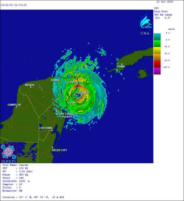
Radar imagery of Wilma, courtesy of the Mexican Meteorological Agency. The eye is over the island of Cozumel. Wilma is forecast to weaken a bit over land, but emerge over the southernmost Gulf as a hurricane. From there, it will track towards the southern Florida peninsula.

Wilma...and some other stuff
* Wilma continues to march slowly through the Caribbean, still as a very dangerous and intense hurricane. The latest advisory from the National Hurricane Center has it as a Category 4 storm, with sustained winds at 155 mph. Hopefully the storm will weaken before making landfall along the Florida peninsula. With cooler sea surface temperatures and stronger wind shear in the path of the storm, it seems like it will probably weaken a bit before landfall. We can certainly hope so. Again, the threat from Wilma here is almost zero.
* How about the cooldown coming? I see that the latest MOS guidance from the GFS paints upper 30's in here by Monday and Tuesday morning! If that trend continues, we will have to continue to adjust our forecast temperatures down. I wouldn't be surprised to see some frost early next week.
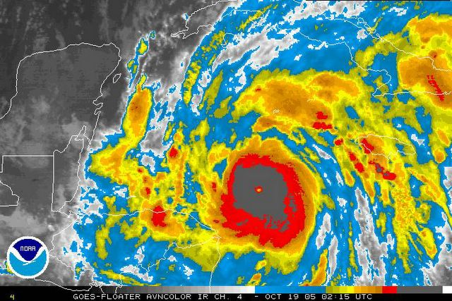
Wilma has weakened just a bit today, but remains a formidable Category 5 hurricane. Notice that the cloudtops are warmer this time than in the image down the page - indicating the weakening.
Wilma - Strongest Atlantic Hurricane Ever
* The jaw-dropping intensification of Hurricane Wilma has made it the strongest hurricane in the history of the Atlantic Basin - an area that includes the Atlantic Ocean, Caribbean Sea and Gulf of Mexico. The minimum pressure of the hurricane is at 884mb, which is 4mb lower than Hurricane Gilbert. Wilma is a powerful Category 5 hurricane with sustained winds of 175 mph or perhaps higher.
* Hurricane Wilma will almost assuredly not have an impact on us. All available data suggests that the storm will move through the Yucatan channel, and eventually make landfall somewhere along the southern Florida peninsula. But, as we all know, there can be changes and surprises along the way. So, we'll continue to watch Wilma closely.
* Here's the official "VORTEX" report from the National Hurricane Center, indicating the lowest pressure ever recorded:
URNT12 KNHC 190835
VORTEX DATA MESSAGE
A. 19/08:00:30Z
B. 17 deg 03 min N
082 deg 20 min W
C. 700 mb 2082 m
D. NA kt
E. NA deg nm
F. 320 deg 166 kt
G. 221 deg 003 nm
H. 884 mb
I. 10 C/ 3073 m
J. 24 C/ 3043 m
K. 10 C/ NA
L. CLOSED
M. C4
N. 12345/ 7
O. 0.02 / 1 nm
P. AF308 0724A WILMA OB 16
MAX FL WIND 168 KT SE QUAD 06:10:20 Z
* Section H is the minimum central pressure, in this case, 884 mb. This reading still must be calibrated by the National Hurricane Center to make sure it's accurate.
Unbelievable Intensification!
* Wilma is strengthening at an unreal pace tonight! The minimum pressure is now down to an astounding 901 millibars - that's a drop of 53 millibars in 4 hours - the largest recorded pressure drop in history...Just unbelievable.
* Here's the latest VORTEX report from the National Hurricane Center:
000
URNT12 KNHC 190446
VORTEX DATA MESSAGE
A. 19/04:32:40Z
B. 16 deg 52 min N
081 deg 56 min W
C. 850 mb 516 m
D. NA kt
E. NA deg nm
F. 116 deg 162 kt
G. 15 deg 003 nm
H. EXTRAP 901 mb
I. 17 C/ 1537 m
J. 26 C/ 1557 m
K. 25 C/ NA
L. CLOSED WALL
M. C4
N. 12345/ 8
O. 0.02 / 1 nm
P. AF308 0724A WILMA OB 07
MAX FL WIND 162 KT NE QUAD 04:31:30 Z
SLP EXTRAP FROM 850 MB
* The good news is that it's out over the water - hopefully it will weaken dramatically before striking land.
* Our track forecast is mostly unchanged, we still think Wilma makes landfall somewhere between Tampa and Miami - again, very subject to change this far out!

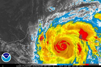
Infrared satellite imagery shows that Wilma is strengthening rapidly. Wilma will likely become a strong Category 3 or low-end Category 4 storm by tomorrow morning. The latest track guidance suggests that Wilma will affect the southern Florida peninsula. The threat to the northern Gulf Coast is almost zero, but we'll be watching things closely.
Wilma a Hurricane...
* The historic 2005 hurricane season continues to amaze. We now have Hurricane Wilma in the western Caribbean Sea. This marks the 21st named storm of the year, which ties 1933 as the most active year on record. Also, this is the 12th hurricane of the year, which ties 1969 as the year with the highest number of hurricanes.
* Wilma has sustained winds at 80 mph, which makes it a Category 1 hurricane on the Saffir-Simpson scale. It is forecast to become a major hurricane over the next few days in the western Caribbean. Computer model guidance suggests that the storm will pass through the Yucatan channel and into the southeastern Gulf of Mexico. From there, the forecast track takes it to the southern Florida peninsula, between Tampa and Miami. Again, this forecast is not written in stone, but the threat for the northern Gulf coast is very, very small.
* What a warm day! Temperatures as of this writing are in the middle 80's across most of Mississippi and west Alabama. The good news is that dewpoint values are running in the 50's, which means that our air is not terribly humid.
* After a few warm days ahead, it seems that we will cool off quite a bit by the weekend. A very deep upper low will be in place over the Ohio Valley, which would funnel some pretty chilly air in here by Saturday and Sunday. The exact position and timing of this upper low is still being debated by the computer models, so the magnitude of the cool air for the weekend is in question. We'll refine the forecast in coming days.