Severe Weather Across the Midwest
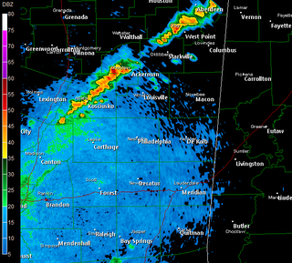
Numerous tornado warnings have been issued this afternoon with discrete cells that are forming ahead of the approaching cold front. Below I have taken a radar image just southwest of St. Louis, Missouri. You will notice that these cells are forming a hook-like feature along the tail-end of the storm. This is indicative of very strong rotation within the storm and where a tornado is likely to form. According to the storm reports on the SPC website, a tornado was confirmed along Interstate 44.


Smoky Mountain Webcams...

*Note: This image is set to update when the webcam itself updates. So, if the sun has set, you'll only see darkness!*
* If you read this space much, you know I am a big fan of fall foliage. While the leaves haven't started to turn much yet, I wanted to share these links with you...These are webcams owned and operated by the National Park Service in the Great Smoky Mountain National Park. If you've never visited the Smokies, I heartily recommend it!
* Here are the links:
http://www2.nature.nps.gov/air/webcams/parks/grsmpkcam/grsmpkcam.cfmhttp://www2.nature.nps.gov/air/webcams/parks/grsmcam/grsmcam.cfm
Podcast: Friday Edition
* This is the Newscenter 11 Podcast - a forecast designed for the increasingly popular IPods! This product can also be played on most personal computers. It's a great way to get extra forecast and weather content at your convenience.
* In today's podcast, I discuss the forecast for the weekend...Check it out:http://media.graytvinc.com/audio/Podcast1.mp3* You can point your IPod or MP3 receiving program to this RSS feed in order to subscribe:
http://feeds.feedburner.com/11Podcast
Severe Weather North of Here...

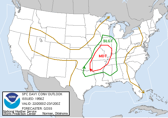
* The Storm Prediction Center has outlooked a large part of the central U.S. for a moderate risk of severe weather tomorrow. Moderate risks are fairly rare and imply a greater severe weather threat than your usual thunderstorm event.
* Fortunately for us, the dynamics with this system will stay far enough north to keep us from having any severe weather worries. However, we will deal with some showers and thunderstorms beginning tomorrow and lasting through Saturday and Sunday. Be sure to carry along the rain gear if you're heading to any football games on Friday night or Saturday.
* The rain will be spotty in nature tomorrow and Saturday, with a more concentrated cluster of rain and thunderstorms likely on Sunday with the approach of the actual cold front.
* I'm taking the day off tomorrow - be sure to have a wonderful weekend!
Cold Morning...
* There were some rather chilly temperatures across our area last night. Meridian hit 47 degrees. It's interesting to note the record low for today is 48 - so we barely missed tying that record.
* Here are a sample of some other cool temps from around MS/AL:
Livingston: 47
Tupelo: 48
Birmingham: 53
I also note that Newfound Gap, TN (in the Great Smoky Mtn. National Park) reached 38 degrees this morning!
Podcast: Thursday Edition
* This is the Newscenter 11 Podcast - a forecast designed for the increasingly popular IPods! This product can also be played on most personal computers. It's a great way to get extra forecast and weather content at your convenience.
* In today's podcast, I discuss the forecast for the weekend...Check it out:http://media.graytvinc.com/audio/Podcast1.mp3* You can point your IPod or MP3 receiving program to this RSS feed in order to subscribe:
http://feeds.feedburner.com/11Podcast
Superb Weather Continues
* What a pleasant day it has been! Temperatures this morning fell into the upper 40's across much of east Mississippi and west Alabama; Meridian's Key Field recorded a low of 49 degrees. More 40's are likely tonight in most places...
* Tomorrow will start a transitional period in our weather. Winds will shift around to the south, and a few clouds will likely show up late tomorrow afternoon. We can't rule out a shower or two after midnight tomorrow night, but most places will stay dry through tomorrow night.
* RAIN? Rain chances definitely increase for Friday, Saturday, and Sunday. While it won't rain during that entire period, rain is possible at any time over the weekend. Be sure to bring along the rain gear to high school football games, just in case!
A Fall Evening...

* What a great sunset on this perfect September day. If you have a picture of the sunset or any other weather-related phenomena, I invite you to share by emailing us a copy:
weather@wtok.comYou'll note the title of this post references Fall, a season which hasn't formally started according the calendar. Meteorologists use a slightly different calendar:
WINTER: December January February
SPRING: March April May
SUMMER: June July August
FALL: September October November
Speaking of the weather calendar, you might find these calendars quite interesting. They combine stunning photos and interesting weather tidbits with the functionality and usefulness of a calendar. Great stuff, check it out:
http://www.weathercalendars.com/* Not much change in the forecast thinking. Wednesday and most of Thursday will be very nice, with plenty of sunshine and highs in the upper 70's/lower 80's. Clouds will begin to return on southerly winds late Thursday, and we will be much warmer Thursday night through Saturday.
Rain chances return to the forecast, with the best chance of rain coming between noon Friday and noon Saturday. That includes the high school football action on Friday night, so dress accordingly by bringing along the rain gear!
Feels Like Fall...
* It sure felt nice to walk outside this morning. Temperatures were comfortable, but more importantly, it was much more crisp and less humid. Days like today are why Fall is wonderful.
* 40's? I notice that almost all of our computer model guidance suggests overnight lows in the 40's tomorrow night. Given the very low dewpoints across northern Arkansas, that sounds about right. Dewpoints in Arkansas are running in the 40's, and this dry, cool airmass will move in our direction through today and tonight. The big issue is wind - if the wind goes calm, we will probably see some middle to upper 40's. If not, more like 50. Regardless, it will be crisp and cool both tonight and tomorrow night.
* WEEKEND: Rain will return to the forecast by late Thursday, although I think the substantial period of rain will come late Friday into early Saturday. This could mean some wet weather for those high school football games Friday night. It will also mean much warmer and more humid conditions for Friday and Saturday. At this point, the threat of severe weather with this front seems quite low.
Odds and Ends...
* A narrow band of showers and thunderstorms is running right along the approaching surface front. These showers and storms could affect the northernmost parts of our area, mainly along and north of Miss. Highway 14.
* I notice the dewpoint in Harrison, AR is 47 degrees - that's some pretty crisp and dry air, and it's moving in our direction. Tomorrow will likely be muggy and somewhat cloudy to start, but we should see sunshine and low humidity by afternoon and evening.
* Frost advisories have been hoisted for much of Kansas and Nebraska tonight...A sign of changing seasons...
* Speaking of changing seasons, check out this "Countdown to the Autumnal Equinox", courtesy of the National Weather Service in Peachtree City, GA:
http://www.srh.noaa.gov/ffc/html/cdown906.html
Hurricane Helene
* Hurricane Gordon continues to run through the open waters of the northern Atlantic...No threat to land; Gordon will soon become extratropical. That simply means it will lose its tropical characteristics and become more like a standard area of low pressure with cold air aloft.
* Helene is still a Cat 3 storm, with sustained winds at 115 mph. Fortunately, it too will stay out to sea. Here's the latest IR image of Helene:

**You can click on this image for a larger version**
Miss/Alabama Rain Update - 3:15 PM
* The rain continues to fall across parts of Mississippi and Alabama. Light rain is the rule across east MS, with the heavier rain moving into west Alabama. The heaviest rain is in southern Sumter County, much of Marengo County, and northern/central Clarke County...
* No severe weather with these thunderstorms - just a load of rain. Radar estimates widespread amounts of 0.25-0.75 inches across the area with a 2.50 estimated rainfall max in eastern Choctaw County, AL.
* The rain will gradually taper off, and we'll see cooler and drier weather tomorrow. We certainly needed the rain - up until today, Meridian's Key Field had reported just over one-third of an inch of rain.
Podcast: Monday Edition
* This is the Newscenter 11 Podcast - a forecast designed for the increasingly popular IPods! This product can also be played on most personal computers. It's a great way to get extra forecast and weather content at your convenience.
* In today's podcast, I discuss the potential for thunderstorms today and the latest on the tropics...Check it out:http://media.graytvinc.com/audio/Podcast1.mp3* You can point your IPod or MP3 receiving program to this RSS feed in order to subscribe:
http://feeds.feedburner.com/11Podcast
Helene Strengthens..
* Helene has become the third major hurricane of the 2006 hurricane season...Max sustained winds are at 115 mph, minimum pressure is estimated at 962 millibars...
* The hurricane won't threaten the Gulf of Mexico, and is a longshot to threaten any part of the U.S. mainland. It will likely curve out to sea.
* STORMY MONDAY? We have a good shot at seeing some thunderstorms tomorrow...The Storm Prediction Center hasn't outlooked us for any severe weather, and our weather office is in complete agreement with that assessment. The air aloft is a bit too warm to support severe weather, 500 millibar temperatures are forecast to be around -5 to -7 tomorrow. -10 or lower temperatures would create a much more unstable airmass. That being written, we will likely deal with a few thunderstorms tomorrow, but they will stay below severe limits in most cases.
* A BIT COOLER: The front responsible for the thunderstorms will quickly push through Tuesday morning, ushering in a cooler and drier airmass. Highs Wednesday and Thursday will likely stay in the lower 80's with low humidity values...Not too bad for the last week of the calendar summer.
Helene Becomes a Category 2 .....
Overnight, Hurricane Helene strengthened to become a strong category 2 hurricane. With the latest 11 am advisory:
Sustained winds: 105 mph
Motion: NW 10 mph
Location: 935 milese east-northeast of the Northern Leeward Islands
Central Pressure: 970 mb
Helene is expected to intensify over the next 24 hours before encountering any significant wind shear. The eye of the storm is still a littl ragged, it does contain areas of very deep convection around the center of circulation. This storm may take a gradual turn to the north-northwest before being picked up by a trough and carried off to the northwest. Helene will not directly impact the U.S., but because Helene is packing very strong winds expect large swells along the eastern coastline.