A Fun Saturday!
Today has been a great day! It first started with Children's First Day. I had a blast spending time with wonderful children and their families at Highland Park. I survived a near injury when the belt buckle harness came loose and a tight bungy cord came flying back at an estimated 50 mph at me...just grazing my leg! Other than that...a wonderful time with music, prizes, games, and quality time with the children!
Next was a quick stop at the Katrina Benefit Concert held at Midtown Grill. Thanks to the bands, vendors, and especially Joe (General Manager) for hosting a great event for a great cause!
To top off the day...I had the pleasure of watching Nebraska win a thriller in double overtime 27-20 over rival Iowa State. For once, the west coast offense actually worked!
As for weather...we will be warmer than normal for the next few days with temperatures getting into the upper 80s. A slight chance of an afternoon shower or thunderstorm is possible on Sunday. The GFS and European computer models are hinting at another shot of cooler air coming in by the middle to end of the week. The teaser we had last week was not enough for me, so lets hope the model solutions are right!
The tropics are semi-active with Tropical Depressions 19 and 20. 19 is in the eastern Atlantic and will move north, well away from the US. TD 20 finally formed in the Caribbean and looks to head across the Yucatan Peninsula before making a second landfall on the Mexican Coast in the Bay of Campeche.
Children First Day!
* Quick reminder that CHILDREN FIRST DAY is tomorrow at 11:00 AM at Highland Park in Meridian. More fun than you can imagine; be sure to bring the kids out for a BIG time!
The weather will be warm, but sunny - might want to wear a bit of sunscreen. The weather through the rest of the weekend will be warm and sunny. There is an outside shot at seeing a shower, but almost everyone will stay dry.
* College football weather:
Starkville - Sunny and Dry. Temps in the lower 80's.
Tuscaloosa - Only a few clouds. Temps in the lower 80's.
Auburn - Mostly sunny. Temps in the upper 70's for this evening kickoff.
* Have a GREAT weekend, and be sure to spend some time with those close to you!
Tropical Weather Update
* Still watching a cluster of storms in the Caribbean. Development has thankfully been very, very slow to occur. The NHC has issued a statement this afternoon after reviewing data from the latest reconnaissance flight:
SPECIAL TROPICAL DISTURBANCE STATEMENT
NWS TPC/NATIONAL HURRICANE CENTER MIAMI FL
310 PM EDT THU SEP 29 2005
DATA FROM AN AIR FORCE RESERVE UNIT RECONNAISSANCE AIRCRAFT INVESTIGATING THE AREA OF DISTURBED WEATHER LOCATED BETWEEN THE CAYMAN ISLANDS AND HONDURAS INDICATE THAT THE SYSTEM REMAINS DISORGANIZED AND THAT A TROPICAL DEPRESSION HAS NOT FORMED. A LARGE AREA OF LIGHT AND VARIABLE WINDS WITH A MINIMUM PRESSURE OF 1009 MB ..OR 29.80 INCHES... WAS DETECTED ABOUT 170 MILES SOUTHWEST OF GRAND CAYMAN ISLAND. HOWEVER... THERE IS NO THUNDERSTORM ACTIVITY COLLOCATED WITH THE AREA OF LOWEST PRESSURE.
UPPER-LEVEL WINDS ARE EXPECTED TO REMAIN FAVORABLE ACROSS THE NORTHWESTERN CARIBBEAN SEA FOR THE NEXT COUPLE OF DAYS... AND THERE IS STILL SOME POTENTIAL FOR THIS SYSTEM TO DEVELOP INTO A TROPICAL DEPRESSION DURING THAT TIME AS IT MOVES SLOWLY TO THE NORTHWEST OR WEST-NORTHWEST. ANOTHER AIRCRAFT IS SCHEDULED TO INVESTIGATE THE
SYSTEM TOMORROW...IF NECESSARY.
* Will watch it closely in coming days...
Tornado Surveys
* Back in the office after a visit to northern Lauderdale County. I was joining the National Weather Service Storm Survey Team - consisting of Doug Butts and Jim Butch from the NWS in Jackson. They concluded that an F1 tornado was most likely responsible for the damage in northeastern Lauderdale County. Earlier, there was speculation that the damage had been caused by a downburst, but a more comprehensive evaluation of the damage concluded that it was an F1 tornado.
* The damage was not widespread, but was significant. A mobile home was overturned and destroyed, and a van was picked up in the air and spun around.
* Good to see our front pushing through. Temperatures are in the 70's, and dewpoints are gradually beginning to fall after a muggy start around here. Cooler will be the word through the next 36 hours. But, we will gradually warm back up this weekend, as highs reach into the middle 80's again. Still, nothing as hot as early last week.
Front Slicing Southward...
* Our first strong front of Fall is making rapid progress towards Mississippi and Alabama. Radar imagery shows a decent band of showers and thunderstorms across northern Mississippi. A few of these storms have prompted severe thunderstorm warnings across northwest Mississippi, and they are moving southeast. Looking at radar, I have to wonder if we shouldn't increase rain chances for this morning.
* There is a rather distinct temperature swing behind the approaching cold front. Temperatures in northern Arkansas have fallen into the 50's, with dewpoints in the 40's. Meanwhile, in the southern part of the state, temperatures are in the lower 80's! 82 is the current temperature in DeQueen, Arkansas, while Fayetteville reports 57 at the midnight hour. Nice, crisp front.
* Latest from NHC on the area of thunderstorms in the Caribbean:
A BROAD LOW PRESSURE AREA IS CENTERED OVER THE WESTERN CARIBBEAN SEAS BETWEEN JAMAICA...THE CAYMAN ISLANDS...AND HONDURAS. WHILE THUNDERSTORM ACTIVITY HAS BECOME MORE CONCENTRATED BETWEEN JAMAICA AND THE CAYMAN ISLANDS...IT HAS CHANGED LITTLE IN ORGANIZATION NEAR THE CENTER OF THE LOW. HOWEVER...UPPER-LEVEL WINDS ARE GRADUALLY
BECOMING MORE FAVORABLE FOR DEVELOPMENT...AND THIS SYSTEM HAS THE POTENTIAL TO BECOME A TROPICAL DEPRESSION OVER THE NORTHWESTERN CARIBBEAN DURING THE NEXT DAY OR SO AS IT MOVES WEST-NORTHWESTWARD ABOUT 10 MPH. AN AIR FORCE RESERVE HURRICANE HUNTER AIRCRAFT IS SCHEDULED TO INVESTIGATE THE SYSTEM TOMORROW MORNING... IF
NECESSARY. INTERESTS IN THE NORTHWESTERN CARIBBEAN SEA AND ADJACENT LAND AREAS SHOULD MONITOR THE PROGRESS OF THIS SYSTEM.* Also, some information to pass along about burning...PLEASE do not burn anything in the next few days. Things have been rather dry, and with lower humidity and stiff winds expected for the next few days after the front passes, there is a higher than usual chance for fires to get out of hand. Here's the word from NWS Jackson:
.FIRE WEATHER...THE MS FORESTRY COMMISSION HAS CONTINUED BURN BANS OVER SECTIONS OF SOUTH AND EAST MS. LARGE AMOUNTS OF VEGETATIVE DEBRIS REMAIN ACROSS THESE LOCATIONS AND RAINFALL TOTALS HAVE BEEN INSUFFICIENT TO ALLEVIATE THE FIRE DANGER. FIRE DANGER WILL INCREASE OVER THE NEXT COUPLE OF DAYS. NORTHWEST BREEZES WILL USHER DRIER AIR
ACROSS THE FORECAST AREA TOMORROW.

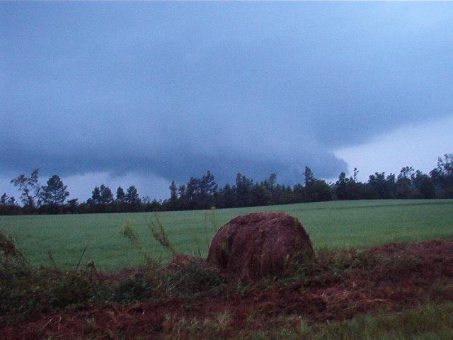
Closer view of wall cloud near Dunn's Falls. BIG thanks to all of our viewers for their pictures. Feel free to e-mail ANY weather picture you have to josh.johnson@wtok.com. There is a chance that we could use it on TV or the blog!


This is a wall cloud shot near Dunn's Falls around 7:00 pm Sunday night.

A funnel cloud between the trees? Hard to say...
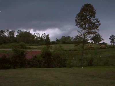
Trees again get in the way, but some scud clouds and a ragged wall cloud appear visible.
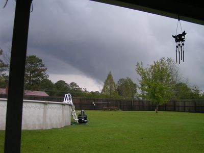
Trees block the view, but still a very impressive wall cloud above the tree-line.
Clarification...
* After talking further with the National Weather Service tonight, I need to make a quick clarification about a statement I made during the 6:00 pm newscast...
** Although yesterday's survey team only found microburst damage in Lauderdale County, the survey has not yet been completed. The NWS (and WTOK) is not denying that there was a tornado in northern Lauderdale County. Many trained storm spotters reported a tornado on the ground. But, so far, the survey team has found only microburst damage. Surveys are continuing tomorrow. **
* Sorry for the confusion. I will post again tomorrow after meeting with the NWS survey team in northern Lauderdale County.
Tropical Update
* Here's the latest Tropical Weather Outlook from the NHC:
A TROPICAL WAVE OVER THE CENTRAL CARIBBEAN SEA IS PRODUCING CLOUDINESS AND A FEW THUNDERSTORMS NEAR JAMAICA AND HAITI... AND OVER ADJACENT CARIBBEAN WATERS. EVEN THOUGH THE THUNDERSTORMACTIVITY HAS GREATLY DECREASED THIS EVENING... UPPER-LEVEL WINDS ARE EXPECTED TO BECOME MORE CONDUCIVE FOR DEVELOPMENT... AND THIS SYSTEM COULD BECOME A TROPICAL DEPRESSION DURING THE NEXT DAY OR TWO. AN AIR FORCE RESERVE UNIT RECONNAISSANCE AIRCRAFT IS SCHEDULED TO INVESTIGATE THIS SYSTEM TOMORROW... IF NECESSARY. INTERESTS IN THE NORTHWESTERN CARIBBEAN SEA AND ADJACENT LAND AREAS SHOULD
CLOSELY MONITOR THE PROGRESS OF THIS SYSTEM DURING THE NEXT FEW DAYS AS IT MOVES WEST-NORTHWESTWARD AT 10 TO 15 MPH.
* We will continue to watch this feature closely in coming days...

The cloud mass southeast of Jamaica is showing signs of development. This could become a tropical depression in the next day or two.
Cooldown Coming?
* Tornado surveys are continuing today. I spoke with members of the survey team earlier this afternoon, they are in Marion evaluating the damage there. I will post later on with their full report about the tornadoes over the weekend.
* It sure looks like we are going to see a return to cooler weather by the end of the week. The GFS MOS guidance puts out a high of 79 for Thursday, with dewpoints running in the 60's. While I'm not sure that we'll be quite that cool, it certainly does appear that we'll see temperatures around 10 degrees cooler than the past day or so. Highs for the end of the work week will mostly be in the lower 80's - pretty nice fall weather!
* The long range forecast is a bit murky. We'll have to continue watching an area of disturbed weather in the northern Caribbean; it shows some potential for development in the next few days. Outside of that, models are hinting at a longwave trough setting up by the latter half of next week. That would allow some much cooler air to spill southward. Far too early to get specific, but the trend appears to be cooler as we get into October.
F2 in Newton County
**Here's the official statement from the NWS in Jackson regarding the tornado that struck Newton County Saturday night**
...STRONG TORNADO DAMAGE SURVEYED IN NEWTON MISSISSIPPI...
F2 TORNADO FOR FIRST 1/4 MILE...THEN F0 DAMAGE FOR LAST 1/2 MILE OF TRACK. TOTAL PATH LENGTH 3/4 MILE...MAXIMUM PATH WIDTH 100 YARDS.
AT ABOUT 734 PM CDT SATURDAY SEPTEMBER 24TH...A TORNADO TOUCHED DOWN AT THE LAZY BOY FACTORY 3 MILES NORTHEAST OF DOWNTOWN NEWTON OR ABOUT 1 MILE NORTH OF INTERSTATE 20 ALONG HIGHWAY 15. THE TORNADO MOVED NORTH-NORTHWEST AND ALMOST IMMEDIATELY STARTED WEAKENING/LIFTING UNTIL IT FINALLY DISSIPATED ABOUT THREE-QUARTER OF A MILE (0.75 MILE) AWAY...JUST NORTH OF RISER-CREEK ROAD WEST OF THE RAILROAD TRACKS.
THE TORNADO PRODUCED F2 DAMAGE ON THE FUJITA SCALE WITH WINDS ESTIMATED AT 120 MPH FOR THE FIRST QUARTER MILE OF THE PATH. A LARGE PART OF THE WELL CONSTRUCTED ROOF OF THE 40 FOOT HIGH LAZY BOY PLANT WAS TORN OFF AND LARGE PIECES OF METAL WERE FOUND AS FAR AS 1/3 MILE TO THE NORTH-NORTHWEST. TWO LARGE DELIVERY DOORS WHERE BLOWN OUT OF THE WEST SIDE OF THE BUILDING. THE IRON GIRDERS WITHIN THE BUILDING WERE BENT AT ABOUT A 10 DEGREE ANGLE...WITH SOME FAILURE OF THE ROOF NEAR THE CENTER AND OBVIOUS BUCKLING OF THE STRUCTURE ON THE WEST SIDE. SMALLER DEBRIS SUCH AS INSULATION WAS FOUND IN A 300 YARD SWATH AS FAR AS 4.5 MILES NORTH-NORTHWEST OF THE PLANT ALONG THE NORTHEAST SHORES OF TURKEY CREEK LAKE. IN FACT...A 2 FOOT BY 4 FOOT SECTION OF METAL ROOFING MATERIAL WAS FOUND AT THE BASE OF THE DAM...4 MILES NORTH-NORTHWEST OF THE LAZY BOY PLANT.
A HALF TON CHEVY PICKUP TRUCK PARKED NEXT TO THE PLANT WAS LIFTED AT LEAST 40 FEET INTO THE AIR...SLAMMED AGAINST AN IRON LADDER...THEN DROPPED BACK ON THE GROUND ABOUT 10 FEET FROM WHERE IT WAS ORIGINALLY PARKED. THE IRON LADDER WAS BENT FROM THIS COLLISION. A LARGE AMOUNT OF INSULATION MATERIAL FROM THE ROOF WAS WRAPPED AROUND THE FRONT AXLE OF THE TRUCK...LIKELY BEING BLOWN UNDER THE CHASSIS WHILE THE TRUCK WAS TEMPORARILY SUSPENDED ALOFT. THE TRUCK WAS PARTIALLY CRUSHED AND THE WINDSHIELD SMASHED IN.
A HOUSE SITTING ON A HILL JUST TO THE NORTH OF THE PLANT WAS NARROWLY MISSED BY THE HIGHEST WINDS...BUT A LARGE PART OF THE WELL CONSTRUCTED HOUSE LOST SHINGLES. THE HOUSE WAS BATTERED BY DEBRIS FROM THE LAZY BOY PLANT AND FROM A THREE RAIL FENCED NEARBY. BOARDS FROM THE FENCE OF 1 X 6 DIMENSION AND A FEW POSTS WERE RIPPED OFF BY THE HIGH WINDS AND LAUNCHED ABOUT 75 FEET AT THE HOUSE...BREAKING A WINDOW AND DAMAGING PART OF THE FASCIA. SEVERAL TREES WERE SNAPPED JUST WEST OF THE HOUSE. THE HOUSE IS ABOUT 400-500 FEET NORTH OF THE PLANT...AND SEVERAL LARGE PIECES OF ROOFING METAL WERE LOCATED IN THE YARD AND IN TREES AROUND THE HOUSE. ONCE PIECE OF METAL WAS BLOWN UNDER THE CAR PORT AND DAMAGED THE FRONT OF A VEHICLE.
A T-POST THAT WAS LAYING FLAT ON THE GROUND JUST WEST OF THE HOUSE WAS PICKED UP AND HURLED AS A MISSILE ABOUT 100 FEET HORIZONTALLY AND ABOUT 25 FEET VERTICALLY. IT WAS THEN IMPALED INTO A UTILITY POLE AND BENT AT A 90 DEGREE ANGLE. THE TOPS OF TREES UP TO 300 FEET NORTHWEST OF THE HOUSE WERE SHEARED OFF ABOUT HALF WAY UP. THEREAFTER...THE DAMAGE DOWNSTREAM ALONG THE PATH WAS LIMITED TO SEVERAL SNAPPED/UPROOTED TREES.
IT APPEARS THAT THE HIGHEST WINDS WERE JUST ABOVE THE SURFACE. THE ELEVATED NATURE OF THE LAZY BOY FACTORY AND THE DAMAGE JUST WEST OF THE HOUSE ON THE HILL CONFIRMS THIS. AS THE CIRCULATION MOVED JUST NORTHWEST OF THE HOUSE AND ENCOUNTERED A DECREASE IN ELEVATION...THE DAMAGE QUICKLY DECREASED. HOWEVER...THE DEBRIS WAS LOFTED RATHER HIGH INTO THE CIRCULATION AND THEN DEPOSIT FOR AT LEAST 4.5 MILES NORTH-NORTHWEST OF THE ORIGINAL TOUCHDOWN.
THE NATIONAL WEATHER SERVICE WOULD LIKE TO THANK THE NEWTON COUNTY EMERGENCY MANAGER...CITY OF NEWTON EMERGENCY MANAGER...NEWTON FIRE CHIEF...AND THE LAZY BOY PLANT FOR THEIR INVALUABLE ASSISTANCE IN SURVEYING THE DAMAGE.
$$
CRAVEN
Surprise, Surprise
* What a wild, wild day. Tornado warnings flew fast and furiously today across Mississippi and Alabama. I have a few thoughts and comments...
* First, what a fantastic job by Renny Vandewege and the WTOK team today. While I was not able to see the coverage, I listened to much of it on AM 1010 WMOX, and Renny and the gang did a wonderful job while dealing with staffing issues - some of which were my fault. Which, brings me to my next point...
* I owe the people of this area an apology. I had plans to spend the weekend at Mississippi State for an unofficial reunion with some close friends of mine - folks I haven't seen in a few years in some cases. Our weather team (and almost everyone else in the weather forecasting community) agreed that the chance of widespread severe weather was very small this weekend. Weighing the apparent small risk, I made the decision to go ahead and go to Starkville. That was the wrong decision. Lesson learned, and I look forward to doing better in the future. This will also be a great lesson about how far we still have to go in the science of weather forecasting. Hats off to Renny for his many hours of hard work! The National Weather Service offices also did a fantastic job.
* We often talk about how fast tornadoes move - a lesson I learned firsthand today. While watching a football game (also watching radar on my laptop), the power began to flicker. The lights went out and a deep rumbling roar could be heard in the distance. The roar grew louder, and the apartment began to shake. At this point, we moved into the interior hallway. The roar lasted for about 15-20 seconds and then subsided. We walked outside and there were trees down everywhere, some of which had fallen on cars. It happened so quickly! Luckily, there were only minor injuries. This was my first tornado, and I now have an appreciation for their speed and power.
* We are continuing to watch the tropics. There are a few areas that show the potential for at least some slow development. Right now, they aren't doing much. We'll hope that continues and keep our eyes on the tropics.
Wild Day
I apologize for not posting fresh warnings on the blog through the afternoon but simply I have been here alone and doing a lot of work on the TV side. Regardless, at one point we had 9 tornado warnings in our area and at least 1 for the better part of 12 hours....busy. There have been several tornadoes spotted including one in Marion. Hopefully nobody was injured.
I am continuing to watch radar and will throughout the night...
Starkville Tornado
Chief Meteorologist Josh Johnson reports a tornado hitting Starkville, including the apartment building he was located, about 30 mins ago. Reports are coming in from multiple sources now that the tornado went directly through the Mississippi State University campus, roughly 100 yards from the Meteorology department building. Some cars were flipped over and a Ford Mustang was smashed by a large tree. Josh is alright!
More tornado warnings for Jasper, Newton, Kemper, and Pickens counties. Will keep you up to date on those... back to radar...
Winston, Smith, Pickens
The tornado warning that was for Neshoba county has been cancelled as that storm has moved now into Winston county. This storm has an impressive velocity couplet on it and we've been hearing reports of funnel clouds being sited by numerous spotters. No word on any touchdowns yet.
Another storm is pushing into Smith County. This storm is a "right mover", meaning it is moving to the right of the rest of the storms' movement. This is usually a good indictation of strong rotation in a storm....watching that one closely for the people in Newton and Jasper counties.
Beginning to hear reports of some damage in Pickens Co near Aliceville, which has seen several rotating thunderstorms move through its area....will pass along any more information I get...
Back to radar...
Neshoba TOR
Tornado Warning for Neshoba county until 2:30 pm...this includes the Pearl River Resort and Philadelphia. An area of impressive rotation was located over the Pearl River Resort area and moving towards the city of Philadelphia...watching this storm closely!
Severe Warning for Lauderdale
Severe thunderstorm warning for Lauderdale county, including the city of Meridian, until 2:00 pm CDT...heavy rain, hail, and wind gusts of 60 mph are possible...
12:45 pm update
Still watching radar closely...tornado warnings in effect for Kemper, Noxubee, and Pickens (AL). The pickens county storm has a well defined hook echo and solid rotation on the velocity products. We still have no confirmed reports of tornadoes, but from the radar images I have seen...wouldn't be suprised if there is at least one or two reports...
More storms moving through Newton and Lauderdale, which are not severe at the time but are certainly bring some heavy rain and gusty winds to the area...
Back to radar...
11:50 am Update
Numerous mini-supercellular storms with impressive rotation moving northeast through the region, and at this time we have tornado warnings for Noxubee, Winston, Neshoba, Kemper, Lauderdale, and Newton Counties. The storm in far northeastern Newton County has very impressive rotation and needs to be watched closely. All of these storms are moving northeast at 45 to 50 mph. Remember...if you are in a warned area, please seek shelter at this time. Move to an interior room on the lowest level of your house or place of business. If you are in a mobile home, it is a good idea to leave and find a sturdy structure.
Newton and Lauderdale Tornado Warnings
New Tornado warnings for Newton and Lauderdale counties until Noon ...these storms are showing significant rotation as they push off to the northeast at 45 mph. Newton and Decatur are in the path of this storm. While this individual cell appears to be moving to the northwest of Meridian, folks near Okatibbee Lake and Collinsville should watch this closely!
Neshoba Storm
As of 11:10am, Neshoba County storm is showing very tight rotation signature, this storm needs to be watched very closely!
Another Busy Day
More severe weather today....at 11:00 am CDT there are 5 tornado warnings in our area: Neshoba, Noxubee, Winston, Smith, and Jasper counties. Many mini-supercellular storms have formed in the last half hour or so and are showing signs of good rotation above the surface. Rotation does not always mean a tornado, but the potential exists.
Also another stronger storm pushing into Newton county, this too showing some weak rotation. No warning issued yet....still watching.