Frz Rain Advisory Cancelled
* The National Weather Service Office in Jackson has cancelled the Freezing Rain Advisory for our countines this evening. Temperatures continue to drop steadily across the area. Meridian is sitting at 35 degrees right now and we do expect the temperature to drop below freezing overnight. However, precipitation has had a tough time developing all afternoon across our area and it looks as if it'll have a hard time tonight. However a few pockets of drizze could still form overnight and anything that does fall will freeze on the surface. For this reason, we still urge you to use caution on bridges and overpasses tomorrow!
* Thank you to David Cole, our weather watcher for posting information this evening in NW Lauderdale county. As Josh mentioned earlier, we would love for you to post information or check other submissions! To do so, click on the following link:
Weather Watchers Site* Winter weather systems love to throw surprises late in the game, so we won't be letting our guard down and neither should you. We'll continue to watch this system overnight and update you with any new information!
Weather Watcher
* Our first weather watcher, David Cole, reports falling temperatures in northwestern Lauderdale County. If you would like to view their reports, or submit some reports of your own, check out our WTOK.com Weather Watcher progam:
WTOK.com Weather Watchers* The NWS has extended the Freezing Rain Advisory farther south, and it now includes all of our Mississippi counties, except Wayne and Jones. The advisory is valid from 6pm tonight until 6am Sunday for the I-20 corridor...The advisory begins at 10pm for areas south of I-20...Here's the text of that advisory:
...FREEZING RAIN ADVISORY REMAINS IN EFFECT FROM 6 PM THIS EVENING TO 6 AM CST SUNDAY...
A FREEZING RAIN ADVISORY REMAINS IN EFFECT FROM 6 PM THIS EVENING TO 6 AM CST SUNDAY.
AREAS OF LIGHT RAIN AND DRIZZLE WILL CONTINUE ACROSS THE ADVISORY AREA TONIGHT. AS TEMPERATURES FALL BELOW FREEZING THIS EVENING...THIS PRECIPITATION WILL BEGIN TO CHANGEOVER TO LIGHT FREEZING RAIN AND DRIZZLE. WHILE THE PRECIPITATION IS EXPECTED TO BE LIGHT...ANY AMOUNT OF FREEZING RAIN OR DRIZZLE CAN CAUSE SLICK ROAD CONDITIONS...PARTICULARLY ON BRIDGES AND OVERPASSES.
A FREEZING RAIN ADVISORY MEANS THAT LIGHT ICE ACCUMULATION IS EXPECTED WHICH COULD MAKE TRAVEL DIFFICULT. SLOW DOWN AND BE EXTREMELY CAUTIOUS WHEN DRIVING ON BRIDGES AND OVERPASSES TONIGHT.
* Our thinking remains mostly unchanged...Some very light freezing rain or freezing drizzle is possible. Light icing or slick spots may develop on bridges and overpasses, so be sure to use extreme caution if you're out and about anytime before noon tomorrow. We still do not expect widespread travel issues as ground temperatures are very warm.
Radar Trends
* We may need to talk to Josh and figure out why all the weather seems to happen on the weekends!!! Just kidding. Another weekend, more winter weather...
* Just checking out the radar to see what's going on. There is a band of rain falling across the highway 84 corridor with a few showers north of it. This is a chilly rain as the temperature in Meridian is 39 right now. Then there is a large gap in precipitation in Central Mississippi before more is found roughly along and north of a line from Grenada, MS to Aberdeen, MS. It looks like more precipitation is trying to fill in through the middle of the state -- a trend we'll watch closely. Light snow was reported in Vicksburg earlier.
* As Josh has mentioned, we don't think significant icing will occur overnight here. HOWEVER, some light and patchy freezing drizzle or freezing rain could occur overnight, as is represented in the Freezing Rain Advisory from I-20 northward in Mississippi. Bridges and overpasses look like the main concern here, with larger travel problems the further north you go. Of course, winter weather would be a great pitcher to have on your baseball team, because it seems to throw pitches you wouldn't expect late in the count. Thats why we'll be here all day long checking it out!! Stay tuned for our latest thinking and be sure to check previous posts throughout the day!
Freezing Rain Advisory
* As I write this, the temperature in Meridian is down to 39...Rain is continuing back to parts of Louisiana and Texas, and cold air is continuing to seep southward as forecast.
Our forecast remains mostly unchanged -
but we will amend it to suggest the possibility of some slick spots on bridges and overpasses. The best chance of this will come along and north of a Newton to Macon to Carrollton, AL line - but the possibility exists as far south as Interstate 20 in Mississippi and Alabama. * Because of these factors, the National Weather Service has elected to issue a freezing rain advisory for the I-20 corridor and points north in Mississippi. A freezing rain advisory means that there could be some very light accumulation of ice on bridges and overpasses. There is no such advisory in Alabama. NWS Birmingham doesn't feel the threat warrants an advisory.
* In our opinion, there could be some light freezing rain or freezing drizzle as far south as I-20 in Alabama as well. And, there could be some slick spots on bridges and overpasses. But, widespread travel problems aren't anticipated...
* BOTTOM LINE: This is a very small "increase" in the threat for us tonight into early tomorrow morning. Also, if you live in Alabama north of I-20, you have the same threat as our Mississippi counties...Just a difference of opinion among NWS offices. Its still the opinion of our weather office that we won't see significant ice accumulations, but there is the threat for a few slick spots on bridges and/or overpasses.
3:30 AM Update
* Interesting to note that Greenville, Tunica and Memphis are all reporting snow at the 3 am hour. This is a bit puzzling, given the forecast of an elevated layer of warm air. That layer of warm air would serve to melt the snowflake. However, given the recent observations, there could be an isolated pocket of deeper cold air - resulting in more snow than originally forecast for northwest Mississippi and western Tennessee. I'd imagine we'll see a change back over to freezing rain and sleet in those areas later today.
* The 6z model guidance is trickling out as we speak, and things look much the same. The new NAM still supports at least the chance of some sporadic freezing drizzle along the I-20 corridor. We still do not anticipate any travel problems...But, for safety's sake, take it easy on bridges and overpasses Sunday morning. As we all know, these winter weather setups can provide hour-to-hour surprises...We'll be watching things closely.
* I'm going to get some sleep now, been a long day. Renny will be in the office later today and will help me keep this space updated over the weekend...
Early Morning Saturday...
* Our thinking remains unchanged regarding our forecast...Be sure to scroll down for our latest thinking.
* West Memphis, AR is reporting moderate freezing rain. The freezing line is continuing its southward march, and will push into northern Mississippi later this morning. Rain will change to freezing rain in places like Tunica and Southaven by 9-10 AM, making travel treacherous. Be sure to exercise extreme caution if you're heading to that area this morning.
* We could see a period of light freezing drizzle along and north of I-20 early Saturday morning. No travel problems, and no accumulation is expected. We'll continue to watch the progress of the freezing line closely...

Here's our latest thinking...Along and north of a line from roughly Monroe to Columbus to Gadsden, Alabama - there could be some light icing with bridge icing. However, there will be a strip of significant ice accumulations across much of southeast Arkansas, north Mississippi, southwest Tennessee and northwest Alabama. Farther north, a strip of 2-4" of snow is likely. We'll continue to refine our forecast through the night tonight and weekend...Check back for frequent updates!

Evening Update
* Our forecast still looks like it's in good shape. We will see showers at times through the day tomorrow. The rain will be cold, and areas north of Highway 82 in Mississippi have the potential for some icing problems. Places like Tunica, Southaven, Tupelo, Corinth and Iuka will likely see significant travel problems.
* In Alabama, the best chance of icing will occur along and north of U.S. 278 - places like Florence, Muscle Shoals and Huntsville. Ice accumulations there could reach up to a quarter inch.
* Much of Tennessee will see wintry weather and significant travel trouble is likely south of Interstate 40.
* Around here, we will still forecast the potential for some very light freezing drizzle early Sunday morning as far south as Interstate 20. We do not anticipate any travel issues. We will warm above freezing late Sunday morning, with an outside chance of a shower. Much of Sunday could be dry.
WTOK.com WEATHER WATCHERS
* We are excited to introduce our newest product - but we need your help! We're creating the WTOK.com Weather Watchers program. This will allow you to post weather information from YOUR neighborhood. We will use your observations on TV and the internet!
* Here's all you have to do...Go to and bookmark the link below. Each day, go to that link and fill in your weather information. You don't have to fill in every field, just the ones that you keep up with. Also, in times of inclement weather, feel free to update us with your reports!
WTOK.com Weather Watchers* This weekend will be a great time for you to start logging those observations, with the threat of some wintry weather. If your temperature gets close to or near freezing, we'd love to know.
Wild Weekend Ahead....
* This weekend's forecast is a very complex and difficult scenario. So, keep in mind that changes to this forecast are quite likely as we go through the next day or two. But, here's our latest detailed discussion about the unfolding winter weather setup for parts of the Southeast...
* An Arctic front is quickly advancing southward through the Southeast. The freezing line now runs from roughly Bowling Green, KY to Jackson, TN to just north of Little Rock, AR. This will continue southward through the day, although its progress will slow a bit because of the daytime heating. There are a few showers along the front, with a more concentrated area of rain falling behind the front.
* The temperatures behind the front are running a bit colder than our models were suggesting. Here are a few cities' actual temperature with comparisons to what our model guidance was predicting:
Little Rock, AR 6 AM
Observed: 34NAM-MOS: 41
GFS-MOS: 40
NGM-MOS: 40
Memphis, TN 6 AM
Observed: 33NAM-MOS: 42
GFS-MOS: 35
NGM-MOS: 42
* This only builds confidence that parts of the Southeast will see a significant ice event out of this. The big questions are where, and how much? We'll take it state by state...
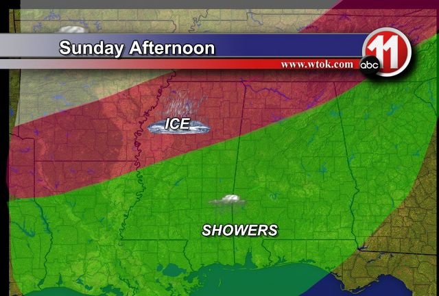
MISSISSIPPI: As of right now, we believe the worst icing will come roughly between Interstate 40 and U.S. 82 in Mississippi. This includes Southaven, Tunica, Tupelo, Greenville, Greenwood, Winona, Starkville, Columbus, and West Point. A Winter Storm Watch has been posted for all of this area. Ice accumulations up to one-half inch are not out of the question, and significant travel problems are almost a certainty. Power outages could also become a problem, mainly in areas that see more freezing rain (as opposed to sleet and snow). The freezing line may come as far south as Interstate 20 early Sunday morning, but the precipitation falling at that time (if any) will be very light. But, we will continue to include a chance of light freezing drizzle along and north of I-20. No travel problems are expected for places like Meridian, Philadelphia, Quitman, Jackson, Newton and Hattiesburg.
TENNESSEE: Major icing could occur roughly along and south of Interstate 40. North of I-40, the precipitation will fall mostly in the form of sleet and snow, and accumulations there should be light (1-3"). Ice accumulations south of the Interstate, including the Memphis metro, will likely be between 0.20-0.40". This will be enough to create very hazardous driving conditions.
ALABAMA: Significant ice accumulations are possible across roughly the northern third of Alabama, where ice accumulations of up to a quarter inch are possible. Travel problems, especially on bridges and overpasses, are likely to develop. This includes cities such as Florence, Muscle Shoals, Cullman, Decatur, Huntsville, Athens, Gadsden and Fort Payne. Like the situation in Mississippi, the freezing line may dart down to the I-20 corridor briefly Sunday morning. This could cause some light freezing rain as far south as Eutaw, Livingston, Birmingham, Tuscaloosa, and Anniston. No significant travel troubles are expected along the I-20 corridor.
* Now that we've discussed WHERE, we need to discuss the timing of the developing weather...
TODAY: Showers will continue at times along the front, and a mass of rain moving across northern parts of Alabama and Mississippi will continue moving east. More showers may develop today, and intermittent rain is possible.
TONIGHT: The showers will continue across central Alabama and central Mississippi, including our area. Farther north, temperatures will fall below freezing, changing the rain over to a mixture of freezing rain and sleet for places like Memphis, Southaven, and Tunica.
SATURDAY: Ice will continue for northwest Mississippi, Arkansas, and much of western and central Tennessee. Here, intermittent periods of rain will continue. It will be cold here, with highs only the in the 40's.
SATURDAY NIGHT: The freezing rain situation will become critical across parts of northern Mississippi, northern Alabama and Tennessee. This is when we expect the worst of the weather for those areas. The freezing line will drop southward through the night, and light freezing drizzle is possible as far south as I-20.
SUNDAY: Light rain will continue at times here, as temperatures warm into the 40's. Freezing rain and sleet will still be a problem for north Mississippi, north Alabama and Tennessee. Snow will also continue across central Tennessee.
* Rain will continue Sunday night, lasting through much of the work week. The Arctic boundary will stall, serving as a focus for waves of weak upper troughs to move overhead. These upper troughs will kick off periods of rain, but they are very difficult to time. So, we'll leave a chance of rain in for Monday, Tuesday and Wednesday. But, keep in mind it will not rain that entire time.
* A few notes...The nature of the rain this weekend will not be a steady, soaking rain for the entire weekend. We will see periods of rain (and ice in the areas outlined above), then periods of dry and cold weather. Our graphic areas under this post remain mostly unchanged. However, this post is the latest info - use it for planning purposes.
* Check out these websites for the latest NWS winter weather products:
Mississippi Winter Storm ProductsAlabama Winter Storm ProductsTennessee Winter Storm Products

The freezing line will slowly move southward through Saturday afternoon. Arkansas, northern Louisiana, north and west Mississippi, north Alabama, and much of Tennessee will likely see a crippling ice storm out of this event. Travel north of Highway 82 in Mississippi or Highway 278 in Alabama is discouraged this weekend.

In the pre-dawn hours Sunday morning, the freezing line may make it as far south as roughly I-20. IF there is precipitation falling at this time, it would be in the form of light freezing drizzle. The best chance of this will come north of a line from Newton to Macon to Carrollton, Alabama. No travel problems are expected at this time.

By late Sunday morning, temperatures across all of our area will warm into the 40's. Cold showers will fall periodically Sunday, but it doesn't seem like a washout.
Ice Problems?
* Everything is set for rain to begin across the area tomorrow, but the big forecast issue is the potential for some light freezing rain as far south as Interstate 20.
* Rain will continue Saturday and into Saturday night. By early Sunday morning, temperatures will fall to or just below freezing from roughly I-20 north. If there is any precipitation still falling at that point, it would fall in the form of some light freezing rain or freezing drizzle. The best chance of this will come north of a line from Newton to Macon. We don't anticipate a significant event out of this, but it most assuredly bears close watching. The arctic airmass is quite shallow, and these very shallow airmasses often give our computer models a hard time. Any adjustment of this airmass will result in large changes to this forecast, so be sure to check back frequently...
* Regardless, temps will warm back above freezing late Sunday and we'll see the cold rain resume. The stalled front responsible for the rain will stay draped across our area, so we'll continue with rain chances through much of the first half of next week.
Noon Update
* Greetings from the parking lot of Wings Restaurant in Tuscaloosa, Alabama. Gotta love wireless internet! I'm up here for an eye appointment this morning, and have had a chance to review the latest computer model guidance...
* The 12z GFS brings the freezing line to roughly I-20 Sunday morning, with some light precipitation lingering. So, we'll introduce the chance of some very light freezing drizzle along and north of a line from Newton to Macon. Still doesn't look like a big deal, even if it occurs. Ground temps are warm, so any icing that occurs would be limited to elevated surfaces and bridges. Temperatures will warm back above freezing Sunday afternoon, leaving us with a cold rain.
* Farther north, its a different story. We expect a major ice and snow event for the I-40 corridor, including places like Little Rock, Jonesboro, Memphis, Jackson (TN), Nashville...with the chance of serious icing as far south as Greenville, Tupelo, and Huntsville. This is a quickly evolving setup, so continue to check back here as we refine the forecast...
* Off to meet some friends for lunch before zipping back to Meridian.
Warm Today, Cold on the Way
* I didn't mean for the title of this post to rhyme...
* On to the real business at hand, the WEATHER. Definitely a day of two distinct airmasses in America. Temperatures across the Southeast are quite warm - we're at 61 as of this writing, and will end up pushing 70-75 in most communities this afternoon. Spring fever will be in full force.
* But, wow, is that other airmass a different story...International Falls' current temp is -26 F. But, don't worry, if they are looking for warmth, they can make the quick drive over to Baudette, MN, where its a balmy -25 F.
* This cold airmass will eventually head south. No, we won't get THAT cold, but temperatures Saturday will likely hold in the 40's for much of the area. This cold air will likely bring a crippling ice storm to parts of Arkansas and Tennessee, with significant icing as far south as extreme northern Mississippi and Alabama. If you have travel plans this weekend north of a line from Greenville, Mississippi to Fort Payne, Alabama, be sure to check ahead.
* Heading out to run some errands, will post again this afternoon.

Spring-like weather will continue this afternoon and evening. Temperatures will fall slowly from the middle 60's to the upper 50's after sunset. Definitely a nice evening for a walk around the block!
WARM!
* What a Spring-like afternoon...A quick look at the 1:00 pm temperature observations around the Southeast...
Meridian 70
Jackson 72
Hattiesburg 72
Biloxi 70
Tuscaloosa 71
Monroe, LA 72
* Nothing Spring-like about the weather in Minnesota today. An advancing Arctic airmass is roaring through the northern Plains, and temperatures in northern Minnesota are plummeting. Here are some 1:00 pm temperatures:
Thief River Falls -2 (wind chill -19F)
Roseau 1
Warroad 1
Fosston 1
Flag Island -2 (wind chill -22F)
* This cold air will arrive here eventually, but it will moderate quite a bit by the time it arrives here. With the higher February sun angle and the lack of snow cover, the magnitude of the cold air here will be limited.
* However, this advancing airmass will play a big role in our forecast. The Arctic front will stall along the Highway 84 corridor. The high temperature forecast for Friday and Saturday will be a nightmare. It's conceivable that Philadelphia could be in the lower 40's while Hattiesburg and Waynesboro are in the upper 60's!
* Areas north of here will have to deal with some serious ice problems. Places like Little Rock, Memphis and Nashville will see periods of freezing rain and sleet. This could impact travel in a big way, so if your weekend plans take you anywhere along the I-40 corridor, you may want to check ahead!
New Snowstorm Rating...
* Interesting read today in the
Baltimore Sun about the new snowstorm rating scale. It's called NESIS, short for Northeast Snowfall Impact Scale. Apparently, the storm that struck over the weekend was a Category Three...
Baltimore Sun NESIS Article* I'll be interested to see this scale progess in years to come. I hope that it is more accurate than the Saffir-Simpson scale (used to classify hurricanes). But, that's a topic for another day.
* WEEKEND WINTRY WEATHER? Not around here - at least that's our thinking right now. An Arctic front will stall around Highway 80. Well north of the front, freezing temperatures will move into parts of Tennessee, northern Alabama, northern Mississippi, and Arkansas. The potential exists for a significant episode of freezing rain across these areas. So, if you have travel plans northward this weekend, be sure to check back here periodically.
* It will be cold here, although not cold enough for wintry weather. Highs Saturday will likely stay in the 40's north of the front, with 60's or 70's likely south of the front. So, it's entirely possible that we could see a 30 degree spread in temperatures across our area. We could see a scenario where Philadelphia was 45 and Waynesboro was 65! We'll refine the difficult weekend forecast more through the week.

Temperatures will fall slowly through the 50's after sunset, which occurs at 5:39 pm. Skies will remain mostly clear.
My Least Favorite Day
* Well today is Valentine's Day, and before you make judgement, I will explain why it is my least favorite holiday. Doesn't it seem like you HAVE to do something romantic on this day. I mean afterall, if you didn't buy your special someone flowers or candy or a gift, wouldn't you come off as shallow and probably be in the dog house forever (I seem to find ways to do this anyways)?
This is why I don't like Valentine's Day....most of the time it is forced. Don't get me wrong, I can be a very romantic guy (when given the chance). But that is the point...its the subtle romantic gestures that go a long ways. Just letting that special someone know that you are thinking about them is the most important. Flowers on a random Thursday....a little note on the mirror in the morning...even just noticing your wife got her hair done can do wonders!
I am not suggesting that you don't get your loved one anything for Valentine's Day -- in fact you better or you are in for a lousy 2 months! But let's not forget that person the remaining 364 days out of the year. As for me...I will be celebrating Single's Awareness Day watching reruns of Who's The Boss.
Happy Valentine's Day!
Hitting the Highway
* Today was a day of travel for me. I left Mobile, Alabama this morning - en route to York, Alabama for a visit with Ms. Radcliffe's Fourth Grade class. What a great bunch of kids! We discussed severe weather safety, and shared a few laughs along the way.
* Alabama Highway 17 offers several historic and interesting communities. Heading north from Mobile on Highway 45, I went left at the Hwy 45/17 split - taking Highway 17 north through Washington County. The first town is Chatom. Chatom must be the "Soul Food" capital of Alabama - I saw several signs for restaurants featuring SOUL food. I sure wish I would have had time to stop for lunch.
* Highway 17 snakes northward through Millry and into southern Choctaw County. The highway takes you through Silas, Cullomburg, Toxey, and eventually into the town of Butler. It's a very scenic highway, with several lakes dotting the landscape. One highlight was a local church sign that said "Worry is the dark room where negatives develop." How true!
* Once into York, I turned right onto Highway 11, going north towards Livingston. Sumter Academy is on the west side of Highway 11, a few miles north of York.
Valentine's Day
* Just a reminder to everyone that Valentine's Day is on Tuesday. Be sure to thank your special someone! For those of us like me who don't have a special someone, it is also Singles Awareness Day! Here are a few locations across the US that have Valentine's Day names. I'm sure they are LOVELY locations!
- Bliss, N.Y.
- Heart Butte, Mont.
- Juliette, Ga.
- Loveland, Colo.
- Loveville, Md.
- Loving, N.M.
- Romance, Ark.
- Romeo, Mich.
- Sugar City, Colo.
- Valentine, Neb. (I've actually been here before...Beautiful place!)
- Valentine, Texas
- Valentines, Va.
* The weather looks nice here on Valentine's Day with highs near 60 and lots of sunshine! Enjoy your week!
Let it snow...
* A few scattered snow showers are affecting the area tonight. Snowflakes have been falling off and on across Meridian the past few hours. One quick burst left a dusting on top of cars during the past hour. Snow is still possible through the overnight hours, however no travel trouble or accumulations are expected
* Skies will clear out by morning, leaving us with a sunny and cold start to the day. Sunny skies will be likely through Wednesday before the next system brings chances of rain by the weeked.