Storm Chase Season
* This is the season that many area universities participate in storm chases in the Great Plains. We've talked a bit about the University of South Alabama's team. They saw a tornado in southeast Oklahoma...You can check out some photos from their trip by clicking this link:
South Alabama Storm Chase Page* Mississippi State's storm chase team is leaving Sunday for the Great Plains. They plan to head to Fort Smith, Arkansas their first day, then travel to Canyon, TX on Monday...
Slight Risk
* SPC has outlooked our area for a Slight Risk of severe thunderstorms today. They mention a possible upgrade to Moderate Risk, but I believe any upgrade they do will likely be west of us. We'll see. I personally believe a Slight Risk handles today's situation best.
* The main threat is going to be large hail...Temperatures aloft are very cold, so it won't take much surface heating to create instability....
* Back to watching the radar...
Neat Video Clip
* This is a video clip of FEDEX planes working around thunderstorms as they approach the airport in Memphis...Pretty cool!
http://www.airlinepilotcentral.com/video-content/current-videos/fedex-thunderstorm-deviations-20060508233.htm
Sad News
* I was saddened to hear of the death of former Congressman G.V. "Sonny" Montgomery this morning. Unfortunately, I never met Mr. Montgomery, but everyone I spoke with who had met him had nothing but wonderful things to say about him. And, his support of this area and our military will be etched in our history and the history of this country.
* For more information, click the following links:
Remembering Sonny Montgomery
Local Leaders ReactFuneral Arrangements
Subscribe Via E-Mail!
* If you are a reader of this blog, but would rather have new posts delivered directly to your inbox, there's a solution for you. Simply enter your e-mail address into the box on the right side of the screen and click "Subscribe".
* You'll receive each post of this blog directly to your email inbox.
* You should know up front that our blog gets updated quite frequently during severe weather...So this may not be for everyone. But, if you want frequent weather updates directly to your e-mail inbox, then you should sign up today!
Podcast: Friday Edition
* This is the Newscenter 11 Podcast - a forecast designed for the increasingly popular IPods! This product can also be played on most personal computers. It's a great way to get extra forecast and weather content at your convenience.
* In today's podcast, I talk the dreaded northwest flow aloft and how that can affect our weekend...Check it out:http://media.graytvinc.com/audio/Podcast1.mp3* You can point your IPod or MP3 receiving program to this RSS feed in order to subscribe:
http://feeds.feedburner.com/11Podcast
Survey Results
* NWS Birmingham has determined that an F1 tornado touched down in Marengo County...Here's the information statement from NWS:
...F1 TORNADO IN MARENGO COUNTY...
NATIONAL WEATHER SERVICE METEOROLOGISTS SURVEYED DAMAGE LOCATIONS ACROSS PORTIONS OF CENTRAL ALABAMA. AT THIS TIME IT HAS BEEN DETERMINED THAT AN F1 TORNADO OCCURRED IN MARENGO COUNTY FROM NEAR JEFFERSON STATION TO NEAR LINDEN ALONG STATE HIGHWAY 28.
THE TORNADO PATH WAS 1.4 MILES LONG AND WAS 150 YARDS WIDE. THIS TORNADO OCCURRED AROUND 3 PM ON WEDNESDAY MAY 10TH AND DOWNED NUMEROUS TREES ALONG ITS PATH. TORNADO WATCH NUMBER 335 WAS IN EFFECT FROM 145 PM THROUGH 9 PM CDT. A TORNADO WARNING WAS IN EFFECT FOR MARENGO COUNTY FROM 223 PM THROUGH 3 PM AND RE-ISSUED AT 255 PM THROUGH 330 PM.
* Meanwhile, NWS meteorologists from Jackson determined that the damage in Scott County was the result of straight line wind damage.
* I'm still waiting on the results of the damage survey from Clarke County, Alabama...I'll post those when they are available...
More Pics...and Thursday's Podcast


* You can click on these images for a much larger version...
* Scroll down for today's podcast...
A big thanks to Jared Thomas for sending these images to us...Jared snapped these pictures off of Highway 19 near Backyard Burgers. The images show the beautiful sunset after the storms had rolled through our area.
*** WE WANT YOUR PICTURES...If you have any weather-related pictures, please feel free to email them to me at:
weather@wtok.com* This is the Newscenter 11 Podcast - a forecast designed for the increasingly popular IPods! This product can also be played on most personal computers. It's a great way to get extra forecast and weather content at your convenience.
* In today's podcast, I talk about yesterday's severe weather and our dry and cool forecast for the next couple of days...Check it out:http://media.graytvinc.com/audio/Podcast1.mp3* You can point your IPod or MP3 receiving program to this RSS feed in order to subscribe:
http://feeds.feedburner.com/11Podcast* Thanks for reading and watching today. We take the responsibility of being your severe weather information source seriously, and we work hard to keep you updated. But, our hard work means nothing without you participating and choosing to stay informed. So, thanks for choosing to be informed!
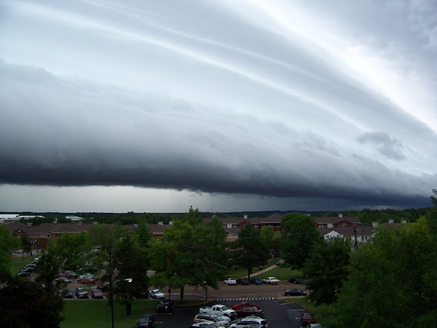
Great Image
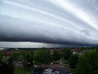
* This picture of a
shelf cloud was taken yesterday on the campus of Miss. State in Starkville. Image courtesy of Rob Hart, a meteorology grad student at MSU.
Threat Ending
* The threat of severe weather has ended across our area. A few showers and thunderstorms continue along the cold front in north MS, but those aren't severe. We may see a few rumbles of thunder as they come through early tomorrow morning, but we don't anticipate any severe weather issues.
* I'm interested to see the NWS survey team findings...There was a possible tornado in Scott County, and several reports of a tornado in Clarke County, Alabama. Once the survey teams' findings are known, I'll post them here.
* Rain was a big problem yesterday. Rainfall amounts of 3-5" were widespread across our area, and flooding occurred in some locations.
SVR Jones/Wayne
* NWS has issued a Severe Thunderstorm Warning for Jones and Wayne counties..
* This storm is affecting almost all of Wayne County right now, including Waynesboro. The main threat is large hail, but gusty winds are also possible.
* Heavy rain will also fall from these storms...
SVR Jasper/Jones
* NWS has issued a Severe Thunderstorm Warning for Jasper and Jones Counties in east MS...
* Large hail is the main threat, along with gusty winds...
* This storm will primarily affect the southern half of Jasper County and the northern half of Jones County...
Severe T-Storm Warning - Smith County
* NWS is about to issue a Severe Thunderstorm Warning for southernmost Smith County. This storm will affect the part of Smith County south of a line from Taylorsville to Mize....
* South of I-20 is still not out of the woods...North of I-20 is in the clear from this band of storms...
Threat Winding Down N of I-20
* The threat of severe weather is beginning to wind down across parts of east Mississippi and west Alabama. The following counties are currently in the clear:
Scott
Newton
Lauderdale
Leake
Neshoba
Kemper
Winston
Noxubee
Sumter
Greene
Hale
* Farther south, the thunderstorms continue south of the I-20 counties...But, none of these are severe as of right now.
* We will have to keep an eye to the northwest...The front is pushing through northwest Mississippi, and a few storms have tried to get going along the front. Some of those could potentially be severe, but the threat is not nearly as high as the band of storms we're currently seeing in south MS.
* Flooding could be a problem in some areas...Radar estimates over 9" of rain in some locales. This number is probably too high due to hail contamination, but I would imagine some places have picked up 4-5" of rain. Meridian's Key Field has measured 2.86" as of 7pm.
* Back to watching the radar...
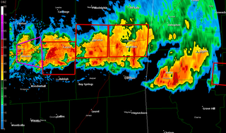
Dangerous Storm -Clarke County Alabama
* The storm that prompted the tornado warning for Clarke County Alabama sure looks impressive...showing very strong signs of rotation...If you live in northern Clarke county, please go to a safe place immediately...lowest floor of your home, interior bathroom, hallway, or closet.
* Getting reports of trees down across I-20 in Newton County...These are near Exits 103, 106, and 114.
6pm Update
* Tornado Warning continues for Clarke County, Alabama until 6:30 pm...Place like Nettleboro, Roundhill, and Morvin will be under the gun...
* Severe thunderstorm warnings continue for Scott, Smith, Newton, and Jasper counties...Large hail is the main threat in those areas.
* Flooding is going to be a big concern...Be careful if you must be out tonight.
* LATE REPORT -- Trees are down and blocking I-20 in Scott County...
Damage Report
* Just got a report of trees down along US Highway 80 between Pelahatchie and Morton...That report is courtesy of WLBT in Jackson...
* Other reports of trees down from parts of Scott County...
Severe thunderstorms continue across our area...Right now, the worst of it is in Scott, Smith, Newton, and Lauderdale counties...Hail is the chief concern.
* We need to stress that flooding is going to be a big problem in flood-prone areas. These storms are training, or moving along the same path as storms before. This will lead to some places getting 4-6" of rain in a short amount of time.
* Ponding on roadways will likely cause hydroplaning. Please slow it down out there!
Warning Update
* Tornado Warning has been issued for Scott and Smith counties...This storm will pass just south of Forest..
* Severe T-Storm Warnings continue for Newton, Kemper, and Lauderdale counties...Hail is the main threat...
* Watch Live at Five for an update in about five minutes...
Severe T-Storms
* Severe thunderstorms with hail continue to affect Newton, Lauderdale, and Choctaw counties...The strongest cell is near the I-20/59 split, just west of Meridian...We've heard reports of dime size hail along US Hwy 80 West.
* More activity building to the west, this will have to be watched closely. The threat of severe weather will continue for the next several hours.
* We are watching the storms out across western Mississippi. These will soon begin interacting with an outflow boundary located just south of I-20. Once they do, the therat of tornadoes will increase quickly...This area of concern includes Smith, Jasper, Clarke, Choctaw (AL) and Marengo (AL)...There is no immediate threat there now, but this area will have to be watched closely in hours to come.
Tornado Warning Continues - Marengo County
* NWS has extended the tornado warning for Marengo County until 330 pm.
* The area with the possible tornado is passing over US 43 near Linden right now. If you live in Linden, take cover.
* The possible tornado will continue moving ESE through eastern Marengo County, passing south of Faunsdale.
New Mesoscale Discussion
* SPC has issued a Mesoscale Discussion, in which they write that the tornado threat is increasing along the I-20 corridor...
http://www.spc.noaa.gov/products/md/md0832.html
Tornado Warning -Marengo County
* NWS has issued a
Tornado Warning for Marengo County until 3pm. Places under the gun include Pin Hook, Linden, Jefferson, and the State Park..
Tornado Warning - Sumter County
* NWS has issued a
Tornado Warning for Sumter County in west Alabama...* There is a typo in their message...movement is east at 40, not 95 mph...
* I'm very concerned about some large hail, especially along the I20/59 corridor from Kewanee and Lauderdale, over into Sumter County...
Severe T-Storm Warning -- Sumter
* NWS has issued a
Severe Thunderstorm Warning for Sumter County...
* Main threat is large hail with this storm...Especially along the corridor from Livingston to York to Cuba...Hail larger than golf balls is possible with this storm...
New Tornado Warning
Here's the text of the new tornado warning for Kemper and Lauderdale...
http://kamala.cod.edu/offs/KJAN/0605101830.wfus54.html
Tornado Warning Extended
* NWS says they will extend the tornado warning for northern Lauderdale and southern Kemper County..
* Area of most concern is north of a line from Suquelena to Lauderdale...The possible tornado will pass north of Meridian.
* Large hail is the main threat in southern Kemper County....
Large Hail Likely -Southern Kemper
* Large hail is very likely right now across southern Kemper County...near Prismatic, over towards Daleville....This will affect much of southern Kemper County in the next 30 minutes, mainly along and south of Highway 16...
Tornado Warning
* NWS has issued a
tornado warning for northwest Lauderdale, northeast Newton, southeast Neshoba, and southwest Kemper County...
* This includes places like House, Tucker, Collinsville, Okatibbee Reservoir, Bailey, and others..
* The warning runs until 130 pm.
Tornado Watch
* A
Tornado Watch is in effect for parts of our area...The watch includes the following counties:
Leake
Neshoba
Kemper
Scott
Newton
Lauderdale
Smith
Jasper
Clarke
Jones
This includes the cities of Bay Springs, Forest, Newton, Philadelphia, Scooba, De Kalb, and Meridian.
The
watch runs until 9:00 pm.
Podcast: Wednesday Edition
* This is the Newscenter 11 Podcast - a forecast designed for the increasingly popular IPods! This product can also be played on most personal computers. It's a great way to get extra forecast and weather content at your convenience.
* In today's podcast, I talk about yesterday's severe weather and the prospects of severe weather today...Check it out:http://media.graytvinc.com/audio/Podcast1.mp3* You can point your IPod or MP3 receiving program to this RSS feed in order to subscribe:
http://feeds.feedburner.com/11Podcast
Weather Settling Down
* Our weather is calming down quite a bit tonight...But, an active day is on tap tomorrow, as more severe weather is possible.
* It seems that the worst of the damage was in Jones County, where there was widespread wind damage in some parts of the county. There was also quite a bit of large hail with a storm that affected Newton, Lauderdale, and Choctaw counties -- another storm dropped large hail in parts of Smith and Jasper counties.
* SPC has outlooked most of our area for a "Moderate" risk of severe weather tomorrow. They include our area in a fairly rare 45% hatched probability of severe weather...Here's their outlook:
http://www.spc.noaa.gov/products/outlook/day2otlk.html* The threat of severe weather will be at a maximum here from around 10:00 am until 10:00 pm...Main threat will be large hail, but all modes of severe weather are possible.
* It's interesting to note that the GFS has much higher instability forecasts for tomorrow when compared to the NAM. Usually, the NAM is much higher than the GFS, so this is a bit of a role reversal. Lately, the GFS has been much more accurate than the NAM, so if that trend continues, tomorrow could be a long day for us.
* I'll post an update around 1:00 am, after the new SPC Day 1 outlook is issued.
Tornado Warning Update
* New tornado warning for Jones County...this is for the storm moving out of Smith County...
* Quick note on the Clarke County, MS tornado warning...Sure looks to me like the tornadic part of that storm will stay well west of Clarke County...But, stay in a safe place in southern Clarke County as a course of least regret.
Tornado Warning - Jasper and Clarke Counties
* New tornado warning for Jasper and Clarke counties...This is for the storm moving out of Smith County..
* Here's the warning:
http://kamala.cod.edu/offs/KJAN/0605092353.wfus54.html* The possible tornado will affect southernmost parts of Jasper and Clarke counties...
* The warning is valid until 8:00 pm.
Tornado Warning - Smith County
* NWS has issued a
Tornado Warning for Smith County valid until 7:30 pm ...The possible tornado is in southern Smith county, moving towards Taylorsville. If you live in southern Smith County, get in the lowest floor of your home. A basement works best; if you don't have a basement, go to an interior bathroom, hallway or closet on the lowest floor of your home.
Mesoscale Discussion
* SPC has issued a Mesoscale Discussion that includes our area....
Check it out:
http://www.spc.noaa.gov/products/md/md0815.html
Large Hail Likely - Smith County
* Radar continues to indicate that there is probably some very large hail falling near Raleigh in Smith County right now. Severe Thunderstorm Warnings continue for:
Smith
Jasper
Clarke
Kemper
Noxubee
Winston
* The main threat in all of these storms will be large hail - perhaps larger than golf balls in some cases.
Two Whoppers
* The title of the post is about two huge storms, not an order at Burger King...
* First storm is crossing the MS/AL state line into Choctaw County...sure looks like there could be hail larger than golf balls within that storm...The storm will affect Butler, Needham, and Lisman within the next 15-30 minutes.
* Second cell is in Scott and Smith counties...affecting places like Polkville, Pulaski, and will soon affect the community of Burns in northern Smith County...
Damage Report...
* We just received a report of trees blow down, golf ball size hail, and a destroyed carport roof in extreme northern Clarke County, just south of the Lauderdale/Clarke County line along Highway 45. Big thanks to our partners at NWS Jackson for the report...
Hail Reports
* Just got a report via phone of golf-ball size hail near Clarkdale...
* Also had a report of quarter size hail in southern Lauderdale County...
* The storm still shows signs of producing very large hail.
* Tornado Warning continues for Clarke County...That storm is showing strong rotation signatures...
Tornado Warning- Clarke County, Alabama
* NWS has issued a
Tornado Warning for Clarke County, Alabama...* If you live in central Clarke County, Alabama, take cover.
* Radar still shows the possibility of very large hail in Lauderdale and Clarke County Mississippi...
Very Large Hail Possible - Lauderdale County
* The storm moving across southern Lauderdale County has strengthened in the last few minutes, and is now showing signs of producing some very large hail...the storm is now passing over I-59, south of the split, and is tracking east. It will affect the southern half of the county.
* In southern Lauderdale County, hail to the size of baseballs is not out of the question!
Large Hail in Newton County
* Just got a report of 2" diameter hail from Newton County....that is larger than golf balls. That storm is moving into Lauderdale County.
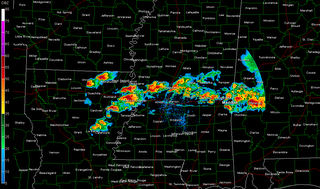
Storms Continue
* Severe Thunderstorm Warnings continue for Newton, Wayne, Choctaw, and Clarke counties...
* The strongest storm is over northern Newton County...That one is likely producing hail larger than dimes in a few places...
* Back to watching the radar...
Hail Report
* Quarter size hail was reported in Mize (Smith County) about 10 minutes ago...
Large Hail Possible- Jasper County
* Watching closely a storm moving through northern Jasper County...This storm has a VIL (vertically integrated liquid) over 55 kg/m^2. On a day like today, this will likely produce some fairly large hail across northeastern Jasper County...Near Rose Hill...This storm will end up in northwestern Clarke County and southern Lauderdale County later on...
3pm Progress Report
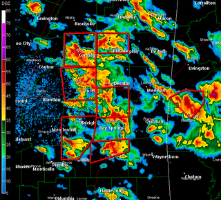
Severe thunderstorms are rolling through east Mississippi and west Alabama...Severe thunderstorm warnings continue for the following counties:
MISSISSIPPI
Leake
Neshoba
Scott
Newton
Jasper
Jones
ALABAMA
Choctaw
Radar Update
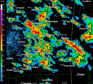
A cluster of strong and severe thunderstorms continues in progress across most of east MS and west AL. Severe thunderstorm warnings continue for Neshoba, Scott, Newton, and Jasper counties in MS, as well as Choctaw County in west Alabama.
Back to watching the radar....
Hail Report
* Just got a report of dime size hail near Emelle in Sumter County....
Quick Note
* There is a line of strong storms moving through Clarke County (MS). These storms are moving over Clarkdale in the next few minutes....
2:20 PM Update
* Powerful thunderstorm moving from northern Leake county into northwest Neshoba County...This storm shows evidence of producing large hail, perhaps as large as golf balls...
* Other severe storms are affectings Scott, Newton, Jasper, Smith, and Jones counties....Severe T-Storm Warnings are in effect for those counties. Hail and lightning are the main threats.
Quick Update
* Severe T-Storm Warnings continue for...
Kemper
Lauderdale
Scott
Smith
Jasper
Jones
Wayne
Clarke (AL)
The main area of concern will be large hail within these storms. Also, lightning is prevalent in these storms.
1:45 PM Update
* Severe thunderstorms are affecting parts of our area. Severe thunderstorms are affecting parts of Lauderdale, Smith, Jones, Wayne, and Choctaw (AL) counties -- another very strong storm is over Kemper County, that storm may go severe at any moment.
* Large hail is the main threat in these storms...Along with very frequent lightning and heavy rain.
* Will try to keep this as fresh as possible...We are having some software issues, and Charles is out doing a news story.
SVR T-Storm Warning
* NWS has issued a
Severe Thunderstorm Warning for Newton and Scott counties...The warning runs until 1:30 pm.
* These storms are producing some hail in their path. The Newton County EMA reports dime size hail in Newton on Pecan Road.
* They are moving east at 30 mph and will affect much of Newton and Scott counties over the next 45 minutes.
Severe T-Storm Watch
* The SPC has issued a Severe Thunderstorm Watch for our Mississippi counties south of I-20...This watch includes the following MS counties:
Smith
Jasper
Clarke
Jones
Wayne
In Alabama, it includes Choctaw and Clarke counties.
The watch runs until 5pm.
* Looking at radar, there are a few intensifying storms over Newton/Scott/Leake counties...Not severe yet, but they could grow severe soon. These storms are producing very heavy rain and plenty of lightning.
Day 2 Outlook
* The Storm Prediction Center has outlooked all of our area under a Slight Risk for severe weather for today and Wednesday...
Here's the Day 1 Outlook, valid for Tuesday:
http://www.spc.noaa.gov/products/outlook/day1otlk.htmlAnd, here's the Day 2 Outlook, valid for Wednesday:
http://www.spc.noaa.gov/products/outlook/day2otlk.html* It's my opinion that the greatest threat of severe weather will come on Wednesday. In fact, I wouldn't be surprised if much of today was dry, with a few scattered afternoon thunderstorms. But, as the front approaches later tonight and tomorrow, the coverage and intensity of the storms will increase. Large hail seems to be the prime threat, but damaging winds and a few tornadoes are also possibilities.
* Time for some sleep...I'll post an update around noon today after I review the morning computer model guidance suite.
Podcast: Tuesday Edition
* This is the Newscenter 11 Podcast - a forecast designed for the increasingly popular IPods! This product can also be played on most personal computers. It's a great way to get extra forecast and weather content at your convenience.
* Today's podcast features a discussion about local universities and their storm chasing efforts...Check it out:http://media.graytvinc.com/audio/Podcast1.mp3* You can point your IPod or MP3 receiving program to this RSS feed in order to subscribe:
http://feeds.feedburner.com/11Podcast
Rainfall Recap
* The last few days have been rather wet across Mississippi and Alabama...In fact, Meridian saw almost 3 inches of rain over the last three days. The wet weather comes after a very dry April.
* Here's how the rainfall broke down:
May 5 (Fri): 0.23"
May 6 (Sat): 0.83"
May 7 (Sun): 1.80"
That puts our three day total at 2.86"...For comparison, we only saw 3.73" inches of rain during the entire month of April...