Ernesto Still Organized
Over the last few hours, Ernesto has strengthened slightly with an increase in wind speed and drop in pressure. The NHC Public Advisory as of 5 pm shows:
WINDS: 60mph (Gusts to 70 mph)
MOVEMENT: WNW 13 MPH
LOCATION: 375 Miles east southeast of Kingston Jamaica
PRESSURE: 997 mb
The environment where Ernesto is located is not favorable for immediate strengthening as there is fairly significant wind shear and cool sea temps. Wind shear is expected to weaken over the next 12-24 hours which could possible allow for very slow intensification.
If Ernesto stays organized and well-entact through the Caribbean, it is highly expected to become a hurricane in the Gulf of Mexico. The track is still uncertain, but I will be watching its development closely and update the blog often.
lauren
Ernesto Update
* Sure looks like Ernesto is on its way to becoming our first major hurricane of the season. Here are the latest numbers from NHC:
Location:
15.1 N
71.2 W
About 420 miles ESE of Kingston, Jamaica
Strength:
Winds: 50 mph
Pressure: 997 mb
Movement is WNW at 14 mph.
* Our forecast hasn't changed much - Ernesto will get into the Gulf of Mexico early next week, and will likely become a major hurricane. It will move over the Loop Current, a region of warm water in the central Gulf of Mexico. Additionally, upper level winds are forecast to be light, which should allow Ernesto to intensify, perhaps rapidly, early next week.
* The forecast track guidance is troubling, but I want to stress that this is not written in stone. Computer model guidance can and does shift - in fact, guidance last year suggested Katrina would turn into Florida, so it can be quite wrong. But, there is growing evidence that Ernesto could pose a substantial threat to the northern Gulf coast late next week.
Ernesto Update
* The new info is out from the National Hurricane Center. Here are the numbers, as of 10pm CDT:
Latitude 14.8 N
Longitude 69.1 W
That puts Ernesto about 555 miles east-southeast of Kingston, Jamaica.
Winds: 45 mph
Movement: WNW 16 mph
* Here is the latest suite of computer model data available this evening: (NOTE: Click on these images for a larger version)

There seems to be two camps of model guidance - one that takes Ernesto into Mexico/Texas, and another that brings this into the northern Gulf of Mexico. The National Hurricane Center is going with the more troubling track:

* Lauren Raymer will be keeping the blog fresh over the weekend, and I'll pop in for an update or two as well.
Tropical Storm Ernesto
* Ernesto has been born today in the Caribbean Sea. This has the *potential* to become a fairly significant hurricane. The key question is whether Ernesto's circulation can survive some pretty intense shear over the next 24-36 hours. IF it does, the environment from then on will be fairly conducive for development.
* IF Ernesto survives, it has the potential to become a very intense hurricane in the central Gulf of Mexico. Water temperatures down there are extremely warm, and shear is forecast to be rather light. So, Ernesto will be one to watch.
* TRACK: We are fairly confident Ernesto will continue through the western Caribbean and come out somewhere in the southwest Gulf of Mexico early next week. From there, it's a guessing game. Bottom line is that everyone from Brownsville to Tampa needs to watch this one closely.
Tropics Get Active...
* Tropical Storm Debby continues out in the open Atlantic. All indications point to this system turning back out to sea.
* A more troublesome system is developing near the Windward Islands. This will officially become either a Tropical Depression (winds <39) or Tropical Storm (winds >39) in the official NHC update later this afternoon. Here's the statement from NHC:
http://www.nhc.noaa.gov/text/refresh/MIADSAAT+shtml/241920.shtml?* Here is the computer model guidance for the system that will soon be Tropical Storm Ernesto (NOTE: Click on the image below for a larger version):
* This storm has the potential to enter the Gulf of Mexico, and it will likely have no trouble intensifying as long as the low-level circulation can stay well-developed. Water temperatures in that part of the world are very warm, and shear is forecast to be light. But, as we all know, forecasting tropical system intensity is extremely difficult. We'll watch closely...
Podcast: Thursday Edition
* This is the Newscenter 11 Podcast - a forecast designed for the increasingly popular IPods! This product can also be played on most personal computers. It's a great way to get extra forecast and weather content at your convenience.
* In today's podcast, I discuss Tropical Storm Debby and an interesting area in the tropics that bears close watching...Check it out:http://media.graytvinc.com/audio/Podcast1.mp3* You can point your IPod or MP3 receiving program to this RSS feed in order to subscribe:
http://feeds.feedburner.com/11Podcast
Podcast: Wednesday Edition
* This is the Newscenter 11 Podcast - a forecast designed for the increasingly popular IPods! This product can also be played on most personal computers. It's a great way to get extra forecast and weather content at your convenience.
* In today's podcast, I discuss the latest ongoings in the tropics...Check it out:http://media.graytvinc.com/audio/Podcast1.mp3* You can point your IPod or MP3 receiving program to this RSS feed in order to subscribe:
http://feeds.feedburner.com/11Podcast
SVR T-Storm Warnings
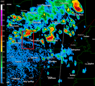
* NOTE: You can click on the above image for a larger version. The red boxes indicate Severe T-Storm Warnings as of the time the image was saved (roughly 2:50 PM)...
* A few of those typical afternoon thunderstorms have strengthened to the point of becoming severe. This, by definition, means that the National Weather Service believes these storms have the potential to produce 3/4" diameter hail and/or 58 mph winds.
http://kamala.cod.edu/offs/KJAN/0608211943.wuus54.html* This storm will pass just west of Philadelphia, and will likely impact the Pearl River Resort...

