Sad News...
* A fatal tornado has struck Columbus County, North Carolina. That's in the southeastern part of the state...Click the link below for more info:
http://www.wral.com/weather/10331683/detail.html
Interesting Story...
* Check out this fascinating story from the
Hattiesburg American:
http://www.hattiesburgamerican.com/apps/pbcs.dll/article?AID=/20061116/NEWS01/611160357/1002* This story, and several other interesting weather related stories, are on the web over at
www.weatherparty.com.
Cold and Gray Day...
* Today will feature several staples of Fall/Winter: cloudy conditions, chilly temperatures, and a stiff wind at times. Highs will struggle to get out of the upper 40's, and winds will blow out of the west at 10-15 mph with higher gusts.
* LAMAR COUNTY TORNADO: The NWS has sent a survey team to evaluate the damage near Sumrall in Lamar County, MS. Their preliminary rating for the tornado was F3 on the Fujita scale - a strong tornado. Despite the damage and injuries we saw, we are indeed very fortunate that the tornado(es) from that storm didn't move over a densely populated area.
* JONES COUNTY TORNADO: The tornado that struck just south of Laurel has been rated an F2. It damaged over a dozen homes in that area, and again, we are fortunate that no loss of life happened.
* KUDOS TO NWS: The National Weather Service offices that serve this area issued very accurate and timely warnings, which we passed along to you. This is how the warning process works, and it worked very well during this event. Major kudos to the NWS offices in Jackson, Birmingham, and Mobile for their outstanding work during this event - their work no doubt saved lives.
* Weekend looks great - cold mornings and cool afternoons. A reinforcing shot of cold air will arrive Saturday night into Sunday. Highs Sunday will likely stay in the 50's. The chilly air will hang around for much of next week, with dry conditions also a big part of the forecast for next week.
Good News, Bad News
* We'll start with the good....The threat of severe weather for our area is almost completely gone. The thunderstorms have weakened and pushed into west Alabama, and none of them are severe at this point. I suppose there is a very small chance we could see a severe thunderstorm warning out of one of these storms in W AL, but frankly that seems like a longshot.
* The bad news...
WSFA out of Montgomery is reporting significant tornado damage in parts of the Montgomery area. The primary area of damage seems to be along the Atlanta Highway...We'll have more on this and the Jones/Lamar County tornado tonight at 5,6, and 10.
* I'm getting ready to go home and catch a nap...Lauren Raymer will fill in for me tonight with your forecast (which looks very calm - albeit chilly - by the way).
Severe Thunderstorm Warnings...
* Quick update: The line of storms is racing eastward and weakening a bit...These storms are still severe, but frankly, just aren't packing the same punch as they did earlier this morning.
* The current Severe T-Storm Warnings are for:
Newton County (10:45am)
Noxubee (10:45am)
Kemper (11am)
Neshoba (11am)
Severe Thunderstorm Warnings...
* The NWS has issued a Severe Thunderstorm Warning for Leake and Winston Counties...
* Damaging wind gusts will be the main threat within this band of storms....
Let's Catch Our Breath..
* A Stormy Night: The first round of severe weather has ended for us. Tornado damage was substantial in Lamar and Jones counties, and we've had sporadic reports of wind damage in Greene and Choctaw counties in west Alabama. Injuries were reported with the tornado in Lamar County.
* Not Out Of The Woods: A second line of storms is racing towards us...The band of storms is near the I-55 corridor. These storms are prompting a load of severe thunderstorm warnings and even a few tornado warnings. Western parts of our area will see this activity by roughly 9 AM, with the Hwy 45 corridor seeing the action by 10 AM, and west Alabama getting into the act by 11 AM or so (These times are rough estimates - your mileage may vary).
* The main threat within this line will be damaging wind gusts, but we can't rule out a few tornadoes in there as well. A key factor will be any sunshine we see this morning. This will further destabilize the atmosphere and could lead to some supercellular thunderstorms ahead of the line. If those form, the risk of tornadoes will increase.
* Some Frustrations: Our weather software really let us down at times this morning...Luckily, it wasn't at a time when we HAD to be on, but it was quite frustrating to say the least...We apologize for the issues with our FirstWarn map and crawl system, and we are working to "fix the glitch." There, it's off my chest - that's my quota of complaining for the rest of this year.
* Stay close to a good source of weather info through the day...
Tornado Warning: Marengo County
* NWS has issued a Tornado Warning for Marengo County until 6:15 AM...
* This radar-indicated possible tornado will impact the southern part of the county..Places along the AL Hwy 10 corridor...Sweet Water, Dixons Mill, Putnam and Magnolia will all see this circulation pass overhead.
* This is a long-track supercell with a history of producing major damage in Lamar and Jones counties....6 people were injured in Lamar County, and we have received a report that around 20 homes were damaged near the Township Road area southeast of the city of Laurel in Jones County...So, this storm has produced some damage, so we urge you to take it seriously...
Tornado Warning: Choctaw Co.
* Tornado warning for Choctaw County until 5:30 AM...
* The possible tornado is very close to Gilbertown..If you live anywhere between Toxey and Silas along AL Hwy 17, you need to be in a safe place - lowest floor of your home, interior bathroom, hallway, or closet.
Tornado Warning Clarke/Wayne
* Tornado warnings continue for both Clarke and Wayne counties...Two separate storms...One possible tornado near Quitman, another in northern Wayne County.
Troubling Report, Courtesy NWS
*** 6 INJ *** SIGNIFICANT STRUCTURAL DAMAGE NEAR
SUMRALL...PARTICULARLY IN THE ROCKY TOP COMMUNITY.
SEVERAL HOMES REPORTED DESTROYED...A MOBILE HOME BLOWN
INTO A POND.
Damage, Injuries - Lamar County
* We are receiving reports of damage with injuries in Lamar County with the storm currently moving through Jones County....
* PLEASE take this storm seriously...If you live in Jones County, be in a safe place..lowest floor of your home, interior bathroom, hallway or closet. This storm is dangerous.
TOR Jones County
* A Tornado Warning will be issued for Jones County in the next few minutes...This is for the very dangerous storm moving out of Lamar/Forrest Counties...
* This potential tornado will affect primarily the southern part of Jones County, passing very near the Moselle community, then going over or just south of Ellisville. IF you live in Jones County, I urge you to take this storm seriously and take shelter in the lowest floor of your home. A basement is best, but an interior bathroom, hallway or closet will work as well.
Very Dangerous Looking Storm
* A very scary looking storm is currently crossing the border between Covington and Lamar Counties...both counties are under tornado warnings, and this storm has the potential to produce a strong, long-track tornado...
* This will pass across the northernmost part of Lamar County, near the Sumrall community...Eventually, it could affect southern Jones county later on...
Tornado Watch: Til 10:00 AM
* SPC has issued a
PDS (Particularly Dangerous Situation) Tornado Watch for all of our Mississippi counties. PDS watches are fairly rare and should be taken seriously.
* The watch runs until 10:00 AM and includes every MS county in our viewing area.
New Watch Possible...
* SPC has issued a Mesoscale Discussion, in which they say a new Tornado Watch is possibly forthcoming for our area:
http://www.spc.noaa.gov/products/md/md2204.html* They also mention that a few "significant/long-track events" are possible - big tornadoes that are on the ground for a lengthy period of time. We sure hope that doesn't happen, but we urge you to continue to keep a close eye on the weather over the next 6-12 hours.
* Our timeline is roughly the same: we expect the worst of the weather to come between 3-4am and roughly noon.
SVR Jones County
* The thunderstorm mentioned in the previous post has prompted a Severe Thunderstorm Warning for Jones County...This storm will affect primarily the northern half of the county, including places like Soso, Sandersville, Laurel, and Summerland.
* Main threat for now is hail, but I wouldn't be surprised if they upgraded this to a Tornado Warning for Jones County...Will update you on TV and in this space should that occur.
1:30 AM Progress Report
* Strongest storm is now in Jones/Covington counties...This storm has a Severe Thunderstorm Warning on it, but is showing increasing signs of rotation...NWS says via IM conference that they may soon upgrade to a Tornado Warning...
* This storm will move into Jones County within the next 30 minutes...We'll be watching closely...
Supercells Lining Up...
http://www.srh.noaa.gov/ridge/radar.php?rid=lzk&product=N0R&overlay=11101111&loop=no* Long line of supercells beginning to get their act together...
Tornado Warning Louisiana
* We have a storm with significant rotation, it has prompted a tornado warning down in Louisiana...St. Helena Parish, LA...
* The environment across S MS is becoming increasingly favorable for supercells and tornadoes...This will be a long night.
* Big thanks to Lauren Raymer, who is helping out on the weather blog tonight. Her entries are being posted under my username, but she will sign them so you know who wrote them...

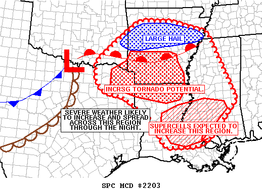
http://www.spc.noaa.gov/products/md/md2203.html
Lots of cells forming in southwestern portions of Mississippi. It's very possible that these storms could intensify very rapidly over the next little while. Low-level winds are very supportive of some cells developing rotation. It is important to review your severe weather safety plans. I will reiterate again that it is very important to have all weather radios on, as the main weather event will occur in the early morning hours.Keep you posted....
lauren
New Tornado Watch
* This one runs until 6:00 AM, and includes only one county in our area -Jones County...But, these storms are moving northeast, and this watch will likely be extended into most, if not all, of our area later Wednesday morning.
http://www.spc.noaa.gov/products/watch/ww0852.html* Also, we've received a report of hail the size of quarters along I-59 near Heidelberg...
* Back to radar duty...
Dangerous situation beginning to unfold off to our west. A very unstable environment is in place across our area and back off to the west. Impressive storms already beginning to ignite down near Natchez and reports of quarter size hail in Heidleburg.
THE NWS STORM PREDICTION CENTER HAS ISSUED A
TORNADO WATCH FOR PORTIONS OF
SOUTHERN AND CENTRAL LOUISIANA
SOUTHWESTERN MISSISSIPPI
COASTAL WATERS
EFFECTIVE THIS TUESDAY NIGHT AND WEDNESDAY MORNING FROM 1125 PM
UNTIL 600 AM CST.
TORNADOES...HAIL TO 1.5 INCHES IN DIAMETER...THUNDERSTORM WIND
GUSTS TO 70 MPH...AND DANGEROUS LIGHTNING ARE POSSIBLE IN THESE
AREAS.
THE TORNADO WATCH AREA IS APPROXIMATELY ALONG AND 90 STATUTE
MILES EAST AND WEST OF A LINE FROM 40 MILES NORTH NORTHWEST OF MC
COMB MISSISSIPPI TO 20 MILES WEST OF INTRACOASTAL CITY LOUISIANA.
FOR A COMPLETE DEPICTION OF THE WATCH SEE THE ASSOCIATED WATCH
OUTLINE UPDATE (WOUS64 KWNS WOU2).
REMEMBER...A TORNADO WATCH MEANS CONDITIONS ARE FAVORABLE FOR
TORNADOES AND SEVERE THUNDERSTORMS IN AND CLOSE TO THE WATCH
AREA. PERSONS IN THESE AREAS SHOULD BE ON THE LOOKOUT FOR
THREATENING WEATHER CONDITIONS AND LISTEN FOR LATER STATEMENTS
AND POSSIBLE WARNINGS.
We will continue to issue the latest advisories and discussions from the NWS in Jackson. If you have a weather radio, it would be a good idea to have it on tonight as the heaviest weather is expected in the early morning hours.
Lauren
SVR Jasper
* NWS has issued a
Severe T-Storm Warning for Jasper County until 11:45 pm...
* This storm will bring gusty winds and the potential for some hail. It's a compact storm, and it's moving through the southeastern part of the county...It will impact Paulding, Vossburg, and Heidelberg...
9:15 PM Update
* A few elevated showers and thunderstorms continue to develop across parts of central MS...These are not severe and will almost assuredly stay below severe limits through the next couple of hours.
* We still expect the worst of the weather from roughly 4 am Wednesday morning until early Wednesday afternoon...Tornadoes, damaging winds, and large hail are all threats of which we must be aware.
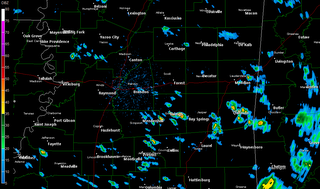
* Here's a radar snapshot - you may click on this image for a larger version:
Afternoon Update
* The thinking hasn't changed much since my post this morning - the stage is set for a significant episode of severe weather across Mississippi and Alabama. A very deep surface low will track across the Midsouth tonight into tomorrow, with an associated cold front. There are many factors pointing toward a significant severe weather episode:
+ Shear: 0-3 KM Storm Relative Helicity values peak at around 500 J/kg...This is before the best instability arrives, however...When the greatest instability is here, the SRH is around 350 J/kg...Still plenty of shear.
+ Wind Fields: The 850 millibar (low level jet - roughly 5000' above ground) is progged to approach or exceed 50 knots tomorrow, which is more than sufficient for severe weather. Farther up in the atmosphere, winds will approach 100 knots - again, plenty of impressive dynamics are involved with this system.
+ Instability: Dewpoint values in southern Louisiana are now approaching and exceeding 70 degrees. That is some very moist and unstable air...The exact progression of the northward push of this moist air will be key. I believe we'll see dewpoint values get up above 60, setting the stage for a round of severe thunderstorms.
* More updates to come...
Severe Weather Possible Later Today and Tonight...
* There is growing evidence that we may be dealing with the threat of severe thunderstorms late this evening and into the overnight hours tonight. Moisture is slowly beginning to increase; we're seeing some 60+ degree dewpoints make their way into southern Louisiana. As the surface low deepens northwest of here, we'll see that moisture-rich air make its way into central MS and AL.
* The magnitude of the threat of severe weather is still a bit in question...The primary cause of the uncertainty is exactly how much of that moisture laden air can get as far north as the I-20 corridor...This will determine how much severe weather we see...The wind fields aloft are impressive, and the shear values certainly suggest a strong threat of severe weather and possibly tornadoes. As long as the moisture return is sufficient, we will likely see an episode of severe weather.
* I will post another update this afternoon with more information...
A Cold Morning
* Meridian saw temperatures below freezing again this morning - I had some frost on the windshield heading into the office early today.
* Forgive the lack of updates - working around the clock. You've probably noticed or heard that we are now without Charles Daniel. He and his wife have moved to Birmingham, and we wish both of them the best of luck!