Saturday...In the Park
* Gotta love a little Chicago now and then! Well it's my turn for 11 1-liners on this pleasant Saturday afternoon
- Despite flooding rains on Monday, we are still 0.24" below normal for March
- We reached a high of 63 today
- Our normal high this time of year is 72
- We should reach 72 by Tuesday
- I won't reach 72 for another 48 years
- I hope I'm around to see it
- Our low last night was 31 - a freeze
- Tonight's forecast low is 31 as well
- This is the first weekend in a long time we haven't had significant weather to deal with
- It's never a good thing when you have zero remaining teams in your NCAA bracket when 8 teams are left in the field
- Don't look now, but my Nebraska Cornhuskers are having a good spring football season
Podcast: Weekend Edition
* * This is the Newscenter 11 Podcast - a forecast designed for the increasingly popular IPods! This product can also be played on most personal computers. It's a great way to get extra forecast content at your convenience!
http://media.graytvinc.com/audio/Podcast1.mp3* You can point your IPod or MP3 receiving program to this RSS feed in order to subscribe:
http://feeds.feedburner.com/11Podcast
Friday Afternoon Musings...
11 1-Liners for Friday
- A cold night is ahead, most places will see freezing temps.
- Many NWS offices have issued Freeze Warnings.
- Winter Storm Watches are posted for parts of Montana.
- They expect nearly a foot of snow.
- We have had no accumulating snow this winter.
- Snow is falling in the Smokies - Click HERE for webcam shot!
- The end of next week looks wet and stormy.
- That is par for the course for the end of March.
- Enjoy these cool temps. August will not be as forgiving.
- A little over two months until hurricane season begins.
- Fingers are crossed worldwide that it will not be as bad as 2005.
Dry and Cool Weekend...
* It has been a long time since we have used the words "dry" and "weekend" in the same sentence! But, this weekend will fit the bill - dry, but cool weather will prevail for Saturday and Sunday.
* Meridian's overnight low last night fell to 35 degrees. This was a few degrees warmer than we forecast, and likely helped us avoid any problems with a freeze. I'm sure there was still a good bit of frost around, especially along and north of Mississippi Highway 14.
* Tonight will again offer the potential for freezing temperatures. The MOS output from the NGM, NAM, and GFS (all computer models we use in part to create a forecast) indicates a low of 33 tomorrow morning. We should note that the MOS products from all 3 models has been too cool lately. So, hopefully we can stay in the middle 30's and avoid any problems.
* Our next chance of rain comes Monday night into Tuesday. That system will not have a big impact on us, and rain chances stay fairly small as it passes. We will begin a warm-up Monday, as highs soar into the upper 60's.
* Be sure to scroll down and check out our Podcast! This is an audio forecast designed for use on IPods and MP3 players. It can also be heard on a standard personal computer. This is a great way to have your forecast "on the go" and at your convenience!
Newscenter 11 Podcast for Friday
* This is the Newscenter 11 Podcast - a forecast designed for the increasingly popular IPods! This product can also be played on most personal computers. It's a great way to get extra forecast content!
http://media.graytvinc.com/audio/Podcast1.mp3* You can point your IPod or MP3 receiving program to this RSS feed in order to subscribe:
http://feeds.feedburner.com/11Podcast
Thursday Thoughts
* First, time for some odds and ends on our 11 1-Liners segment. More ODDS than ends... There is a lot of WINTRY weather going on today:
11 1-Liners for Thursday
- A few fluries fell this afternoon on the campus of Miss. State.
- The temperature was in the middle 40's.
- Once the snow began, temps fell into the 30's.
- This was possible due to evaporational cooling.
- Snow at these temps is very rare.
- We expect no flurries here. Maybe a sprinkle.
- Heavy Snow Warnings are in effect for the Smokies.
- 4-6 inches of snow is expected there.
- A Freeze Warning is in effect for areas north of I20 tonight.
- Be sure to bring in any tender plants.
- Widespread frost is likely; temps in the 20's are possible.* The weekend looks nice - plenty of sunshine, but cool. Highs on Saturday and Sunday will likely struggle to reach the middle 60's after cold mornings both days.
* Our next chance of rain comes Tuesday, but it doesn't seem like a big deal at this point. A few showers are possible, but this system will not bother us with any severe weather problems.
* NEW GOODIES: My new laptop has arrived! This is going to allow me to introduce some new forecast content to this space. I will begin producing a daily video discussion that will get into the "nuts and bolts" that go into our forecast. This discussion will be a "vodcast" - video podcast. For those of you who own video IPods, these videos will be compatible with those. Additionally, we will begin producing audio podcasts - a brief audio forecast playable on standard IPods. It will take a few days for me to get the necessary software, so be watching this space for updates on these new products!
A ribbon of clouds is rolling through much of Mississippi. These clouds will move through later today, and sunshine will resume this afternoon. There are some light rain showers out in the Mississippi Delta. We could see a few of those showers later this afternoon. A full forecast update will be posted here this afternoon!

4 Tornadoes
* The NWS has confirmed damage from four tornadoes across parts of south Mississippi during Monday's storms. Here's their report:
PUBLIC INFORMATION STATEMENT...UPDATED
NATIONAL WEATHER SERVICE JACKSON MS
515 PM CST WED MAR 22 2006
...NWS SURVEY TEAM FINDS FOUR TORNADO TRACKS IN SOUTHEAST
MISSISSIPPI FROM MARCH 20TH STORMS...
TORNADO 1...NOTE REVISED TIME BASED ON ADDITIONAL RADAR AND SURVEY
ANALYSIS...
TIME...1230 PM
LOCATION...COVINGTON COUNTY...1 MILE S OF HOT COFFEE TO 3 MILES NE
OF HOT COFFEE
FUJITA RATING...F0
WIDTH...50 YARDS
LENGTH...4 MILES
DAMAGE...LIMITED TO A NUMBER OF TREES BEING SNAPPED AND A FEW
KNOCKED DOWN.
TORNADO 2...
TIME...1245 PM
LOCATION...JONES COUNTY...4 MILES NNE OF HEBRON TO 1 MILE NNW OF
GITANO
FUJITA RATING...F0
WIDTH...50 YARDS
LENGTH...3 MILES
DAMAGE...STARTED WITH SOME TREES BEING DOWNED ON CARTER DEE ROAD.
SOUTHERN PINE ELECTRIC PERSONNEL OBSERVED THE WEAK TORNADO CROSSING
HIGHWAY 28 JUST NORTHWEST OF GITANO. DAMAGE HERE WAS LIMITED TO A
COUPLE OF DOWNED TREES AND SOME MINOR ROOFING DAMAGE.
TORNADO 3...
TIME...320 PM
LOCATION...JONES COUNTY...4 MILES SE OF SOSO TO SHADY GROVE
FUJITA RATING...F1
WIDTH...50 YARDS
LENGTH...8 MILES
DAMAGE...DAMAGE STARTED AS A FEW TREES BEING KNOCKED DOWN. DAMAGE BECOME MORE CONCENTRATED AND SIGNIFICANT NEAR THE SHADY GROVE COMMUNITY. NUMEROUS TREES AND POWERLINES WERE DOWNED. SEVERAL LARGE TREES WERE KNOCKED OVER OR SNAPPED IN HALF. ONE LARGE TREE SNAPPED IN HALF AND LANDED ON A NEW SHED...DESTROYING IT.
TORNADO 4...
TIME...410 PM
LOCATION...LAMAR COUNTY...1 MILE N OF PINE RIDGE TO 3 MILES ENE OF PINE RIDGE
FUJITA RATING...F1
WIDTH...50 YARDS
LENGTH...3 MILES
INJURIES...1 PERSON WAS INJURED WHEN BLOWN ACROSS A CEMENT PATIO DAMAGE...STRUCTURAL DAMAGE AND TREES DOWN ALONG WIDDEN ROAD. THE ROOF WAS TORN OFF THE UPSTAIRS BACK DECK/PATIO OF A WELL BUILT TWO-STORY HOME ALONG WITH OTHER SIGNIFICANT ROOF DAMAGE TO THE HOME. THE DECK OF ANOTHER HOME WAS DAMAGED. A NUMBER OF LARGE TREES WERE
DOWNED AND SNAPPED IN HALF. THIS WAS THE MOST INTENSE TORNADO SURVEYED...WITH DAMAGE ON THE HIGH END OF THE F1 CATEGORY.
THE NWS WOULD LIKE TO THANK OUR PARTNERS IN EMERGENCY MANAGEMENT AS WELL FOR THEIR ASSISTANCE IN GATHERING DAMAGE REPORTS AND CONDUCTING STORM SURVEYS IN THESE AND OTHER AREAS OF SOUTHEAST MISSISSIPPI. WE ALSO THANK THE EMPLOYEES OF SOUTHERN PINE ELECTRIC WHO PROVIDED DETAILED REPORTS ON THE STORM NEAR THE GITANO COMMUNITY.
Sprinkles Possible
* Radar is beginning to fill in across parts of Louisiana and southwest Mississippi. However, this shield of light rain will have a very hard time moving north due to dry air in place where we are. We can't rule out a few sprinkles, but significant rain is quite unlikely.
* The story will not change much tomorrow: a few early showers are possible, but most places will stay dry. The best chance of rain tonight and early tomorrow will come along and south of I-20. Even there, we don't anticipate any appreciable rain.
* Another thing we'll have to keep in mind is the possibility of freezing temperatures Friday and Saturday morning. This potential exists across all of our area, and northern parts of our viewing area could see temperatures in the upper 20's.
* The weekend looks great, but cool. Highs will reach the 50's and 60's, with warmer temperatures arriving for Sunday. Rain chances gradually increase Monday and Tuesday. There does not appear to be a large threat of severe thunderstorms with this system, as the best dynamics will pass well north of here. We'll continue to watch things...
11 1-Liners for Wednesday
11 1-Liners for Wednesday
- Forecasting low clouds in a cold air advection setup is tough.
- Interesting to note light snow flurries reported in N. AL this AM.
- NWS Jackson has issued a Freeze Watch for Thu Night/Fri AM.
- Fri Night will be even colder than Thu Night.
- Bring in any tender plants or flowers.
- Incredible Hawaii monthly rainfall totals of over 100" in spots.
- Our own Charles Daniel became engaged in Hawaii in August.
- The River Flood Warning for the Sucarnoochee in Sumter Co. has been cancelled.
- Waters are forecast to stay just below flood stage.
- Flooding is a bigger problem along the Pearl River right now.
- Some campsites at Burnside Water Park are flooded.
A Cold and Cloudy Morning

* These pesky low clouds are really hanging tough! Forecasting the progression of low clouds on a cold day is one of the most difficult forecasts we are often asked to make.
* Meridian is sitting at a balmy 40 degrees at the time of this writing. We are still forecasting these low clouds to dissipate and temperatures to warm at least into the middle 50's later today.
* The 12z (morning) computer model guidance looks about the same as our going forecast. We'll still include the chance of a shower or sprinkle tomorrow, but many places will stay dry.
* Laptop Watch 2006: My laptop is listed as "Out For Delivery" on the UPS tracking website. Very cool! I'm sitting by the door waiting!
* I'll have a complete update, including 11 1-Liners, posted later today!
Dry and Cool Weather Ahead...
* Given the recent flooding issues, we sure could use some dry weather. The good news is that we are going to get exactly that. Today looks great, maybe a few clouds early, but the overwhelming majority of the day should be sunny. But, it will be chilly. Highs will reach only into the 50's with a light northerly breeze.
* Tonight looks cold, with readings falling into the middle 30's. The coldest mornings, however, will arrive Friday and Saturday. Temperatures on both of those mornings could fall below freezing in some locations. So, if you have any potted plants or flowers outside that are blooming, you may consider bringing those indoors.
* We will still mention the chance of a passing shower Thursday. However, it does not look significant at all. In fact, many communities will likely stay dry, especially north of Interstate 20.
* Dry weather is the rule through the weekend. Our next chance of rain comes early next week, when the GFS advertises a strong area of low pressure rumbling from the Plains to the Great Lakes. If you take the GFS at face value, we could be dealing with a line of thunderstorms early next week. It seems that the best dynamics will pass north of here, limiting the threat of severe weather.
* I sure enjoyed visiting with the Leadership Lauderdale group today. They are a group of 11th graders from various schools (private, public, and home-schooled) around our area - a very intelligent bunch.
Severe Weather Reports
* It turns out that there was a tornado down in Jones County yesterday - near the Shady Grove community. That's northwest of Laurel. The NWS has rated the tornado an F1. Given the presentation of that storm on radar yesterday, that's not really a big surprise.
* If you want to check out the Storm Reports for yourself, check out this website:
http://iwin.nws.noaa.gov/iwin/ms/public.htmlNot only does this site have storm reports, but it also has various public information statements issued by the NWS...A great bookmark for a weather enthusiast.
* I wanted to pass along a fascinating story about a man in Missouri. He was thrown almost a quarter of a mile by a tornado and lived to tell about it. Read his fascinating story by clicking the link below:
Missouri Tornado Throws Man* I will post a full forecast discussion in a few hours. My new laptop is being shipped today, and I'm going to see if they've tried to deliver it to my home yet. As a bona fide computer geek, I'm very excited!
11 1-Liners
* I'm going to try something a little different this morning. As you know, we are called Newscenter 11. And, I know that many people enjoy one-liners and brief pieces of information. Why not combine the two? I'll write a daily piece called "11 1-Liners" that will simply be 11 short statements - usually weather related, but you never know what might end up here.
11 1-Liners for Tuesday:
- Meridian ended up with 2.93" over the 5 day wet period.
- Our average monthly rainfall for March is 6.93".
- This makes March our wettest month of the year on average.
- This week is Flood Awareness Week - very appropriate.
- Today's emphasis is on Turn Around Don't Drown.
- I was very disappointed to see people driving through flood water yesterday.
- That video was aired all across the country on Good Morning America.
- A huge snowstorm brought parts of Nebraska almost 2 feet of snow.
- That would be 2 feet more than we saw in Meridian this winter.
- It can snow here in March or April, but that is very rare.
- One of my first memories was a big snowstorm in April 1987 (I was 4).* Quick Forecast: The work week still looks good - cool, but dry. Highs in the upper 50's and lower 60's, lows near freezing. A small chance of rain Thursday, but nothing too signficant. Cool and dry right through the weekend.
* I'll have a full discussion posted this afternoon...
Flooding Update
* This is a good time to have a thorough discussion about the flooding situation across east Mississippi and west Alabama tonight. Before we do that, feel free to scroll down and check our thoughts for the rest of the week...
* Flooding Concerns:
Sucarnoochee RiverCurrent: 10.7 feet (6pm Mon)
Forecast: Above Flood Stage (18.0 feet) 6am Tue
Crest: 20.0 feet 6pm Tue
Flooding is forecast in flood prone areas along the Sucarnoochee River near Livingston...
Chickasawhay River - EnterpriseCurrent: 10.7 feet and rising
Forecast: Above Flood Stage Early Tomorrow Afternoon
Crest: 27.5 feet Wednesday Morning
Pearl River - PhiladelphiaCurrent: 11.5 feet and rising
Forecast: Above Flood Stage Early Tomorrow
Crest: 14.5 feet Tuesday Morning
* I will pass along more information as it becomes available...
Evening Update
* Things are beginning to get a bit better from a weather standpoint...There is still one strong thunderstorm - it is moving across northwestern Wayne County and will soon track into southern Clarke County. Gusty winds and perhaps some small hail will accompany this storm.
* Elsewhere, there are widespread showers and even some small thunderstorms across much of the area. These storms will not be severe, but they could exacerbate the flooding situation...Showers and the occasional thunderstorm will continue for the next several hours, but the rain should end by daybreak tomorrow.
* Tomorrow looks like a fairly nice day. Clouds will hang tough early in the day, but we should get plenty of sunshine as the day progresses. Temperatures will run on the cool side, as most locations top out in the lower to middle 60's with a stout westerly breeze.
* Cool and dry weather headlines our forecast for the rest of the week....We may even see some freezing temperatures during the morning hours later this week! We will mention a small chance of a shower Thursday, but it doesn't look like a big deal.
* I'm looking forward to speaking with the Leadership Lauderdale group tomorrow. They are touring our station...Should be a good time!
Severe T-Storm Warning -- Choctaw
* A severe thunderstorm warning remains in effect for Choctaw County - the band of thunderstorms is now just east of Highway 17, and is racing eastward. The main threat with this band will be damaging wind gusts...
* These storms will impact almost all of Choctaw County over the next 30 minutes...
* Thunderstorms continue across much of central Mississippi, but they are not severe. These storms are elevated, or based on top of a layer of cool air near the ground. That means that the main threat with these storms will be some small hail.
* NWS has cancelled the Tornado Watch for all of our Mississippi counties except for Wayne. The Alabama counties continue under a tornado watch until 10:00 pm, but I anticipate some of these counties to be cleared in the next few hours.
Severe T-Storm Warning -- Wayne
* NWS Mobile has issued a
Severe Thunderstorm Warning for Wayne County. The warning runs until 6:30 pm and includes the city of Waynesboro.
* This is a line of thunderstorms that is producing some very strong wind gusts and perhaps some hail as well. It will be approaching Waynesboro in the next 10 minutes, then sweep eastward through the remainder of Wayne County.
* Stay away from windows and off the phone. Flooding is also a concern area-wide, and we want to reiterate that if you don't have to be out tonight, don't venture out. Many roads have some standing water on them, which can create a driving environment favorable for hydroplaning. Slow down and be careful tonight if you must be out!
Tornado Warning -- Wayne and Choctaw
* NWS Mobile has issued a
Tornado Warning for Wayne (MS) and Choctaw (AL) Counties. The warning goes until 5:15 PM, and is mainly for southern Choctaw and northern Washington counties. It also includes easternmost Wayne County, but the potential tornado is approaching the state line right now and will soon be into Choctaw County.
* If you live in Silas, Cullomburg, Toxey, Gilbertown, or Coffeeville, go ahead and seek shelter. If you have a basement, go there. If not, go to the lowest floor of your home. An interior bathroom, hallway or closet works best.
Meridian Flooding
* Getting some serious reports of flooding now in downtown Meridian. Rush Hospital's Emergency Room has around 2 feet of water in it, and many other areas are experiencing some flooding. Here are some other areas that we're getting reports from:
14th Ave. and 17th St.
8th Ave. and 28th St.
State Blvd. and 20th St.
Arthur St. and 59th Avenue
* Ideally, no one would be out driving for the next few hours. If you must venture out, here are some flood safety guidelines:
Do not walk through flowing water. Currents can be deceptive; six inches of moving water can knock you off your feet. Use a pole or stick to ensure that the ground is still there before you go through an area where the water is not flowing.
Do not drive through a flooded area. More people drown in their cars than anywhere else. Don't drive around road barriers; the road may be washed out. A car can float in as little as two feet of water.
Stay away from power lines and electrical wires. The number two flood killer after drowning is electrocution. Electrical currents can travel through water.
Tornado Warning -- Jones
* NWS has issued a Tornado Warning for Jones County. The text of the warning states that radar has detected a possible tornado near Pine Belt Airport, moving northeast...The warning runs until 4:45 PM. As we've said before, the best place for you to be is a basement or storm shelter. If you don't have either of those, go to the lowest floor of your home and get in an interior bathroom, hallway or closet.
* The tornadic part of the storm will be over southern and southeastern Jones County, south and southeast of Ellisville.
* Be sure to scroll down for more important information.
New Tornado Watch
* In all of the fast and furious warnings, we haven't had a chance to mention the new Tornado Watch. It is in effect until 10:00 pm, and includes most of our area along and south of Interstate 20. It includes these counties:
Lauderdale
Clarke
Wayne
Greene (AL)
Sumter
Hale
Marengo
Choctaw
Clarke (AL)
* The old tornado watch (in effect until 5:00 pm) includes Newton, Scott, Smith, Jasper and Jones Counties.
* Getting a report now of a funnel cloud on the west side of the city of Hattiesburg.
Tornado Warning Clarke/Wayne
* NWS has issued a
Tornado Warning for Clarke and
northern Wayne County...The warning runs until 4:15 pm...
* If you live anywhere between Miss. Highway 18 and U.S. Highway 84 in Clarke or Wayne Counties, take cover now. This storm shows strong signs of rotation.
* Will continue to watch things and update this space as often as I can.
Tornado Warning -- Smith/Jasper/Jones
* NWS has issued a
Tornado Warning for southern Smith, southern Jasper, and northern Jones County. The warning runs until 3:45 PM..
* This storm shows very strong signs of rotation - if you live in Taylorsville, take cover now!
* The potential tornado will track along the Jasper/Jones county line, eventually moving into southern Jasper County. If you live in northern Jones or southern Jasper Counties, you need to be in a safe place - basement if you have one, if not - lowest floor of your home. Get in a bathroom, hallway or closet in the interior of your home.
Severe T-Storm Warning -- Smith County
* NWS has issued a
Severe Thunderstorm warning for Smith County until 3:15 PM..
* The main threat with this storm is damaging wind - to the tune of 65-70 mph in isolated spots. The worst of it affect almost all of Smith County through the next 40 minutes.
* If you live in Smith County, be sure to stay indoors and away from windows. Also, stay off of wired telephones - they can bring electricity into your home via phone lines...
2:30 PM Update
* Just spoke via phone with a woman in Clarke County - her power is out and she had no way of getting information. Good thing she called!
* There are some power outages across parts of Clarke County, how many we do not know at this time.
* Round 1 of the severe thunderstorms has pushed into Alabama. However, another band of severe thunderstorms is moving through south-central Mississippi at this time. This will impact much of our area along and south of I-20 later this evening.
* North of I-20, flooding will be a concern. Radar estimates that 3-4" of rain has already fallen, and another couple of inches is certainly possible. The Pearl River will be particularly at risk, because a lot of rain is falling in its catch basin (central MS). The Tombigbee, Black Warrior and Chickasawhay will also have to be watched closely.
1:45 PM Progress Report
* NWS has issued a
Flood Warning for Lauderdale County. Rain is falling a 2-3" per hour rate! Be very careful if you must be out driving - drive slowly and leave plenty of room between your vehicle and the vehicle in front of you.
* Additionally, the NWS has issued a
Severe Thunderstorm Warning for Choctaw County in west Alabama. This runs until 2:15 pm, and the main threat comes in the form of damaging wind gusts...
Severe T-Storm Warning -- Lauderdale County
* A Severe Thunderstorm Warning has been issued for southeastern Lauderdale County until 2:30 pm...
* The worst of it will be east of Hwy 45 and south of I-20 -- places like Vimville, Increase, Zero -- maybe even as far north as Toomsuba and Kewannee. The main threat is going to be damaging wind gusts, but we could also see some hail as well...
Other parts of Lauderdale County will see torrential rains and gusty winds.
Torrential Rain/Severe Update
* Still watching the Clarke County line of storms closely. This will continue pushing eastward through eastern Clarke County through the next 20 minutes. While there is a tornado warning in effect, the main threat in our opinion is damaging wind gusts in places like Middleton, Energy and Snell...
* Torrential rain is falling in downtown Meridian...If you're out driving, be sure to slow it down as hydroplaning will likely be an issue. Also some gusty winds in Meridian.
* Flooding is also a concern - more on that once the severe weather threat winds down for a bit...
Tornado Warning Clarke County
*
Tornado Warning for Clarke County -- this is for the storm moving out of Jasper County....
* This storm will likely contain strong winds in addition to the threat of a tornado...It will affect Stonewall and Enterprise within the next 15-20 minutes.
* If you are in Clarke County, stay indoors and away from windows. Also, take cover in the lowest floor of your home. A basement works best, but if you don't have one - go to an interior bathroom, hallway or closet on the lowest floor of your home.
Watching Jasper County...
*
Tornado Warning for Clarke County -- this is for the storm moving out of Jasper County....
* This storm will likely contain strong winds in addition to the threat of a tornado...It will affect Stonewall and Enterprise within the next 15-20 minutes.
* If you are in Clarke County, stay indoors and away from windows. Also, take cover in the lowest floor of your home. A basement works best, but if you don't have one - go to an interior bathroom, hallway or closet on the lowest floor of your home.
Tornado Warning Update -- Smith/Jasper/Jones
*
NWS continuing the Tornado Warning for southeastern Smith, extreme northwest Jones, and Jasper Counties...* The part of the storm with the possible tornado has just crossed Highway 15 near Stringer - and is moving northeast...On its current track, it will move across south central Jasper County and then cross Highway 503 between Heidelberg and Paulding in 20-35 minutes.
* The main threat with this is in Jasper County. The tornado threat from this storm for Smith County has ended for now - and the threat in Jones is only for the extreme northern part of Jones County...
Tornado Warning...
* There is now a
Tornado Warning for southeastern Smith, northern Jones, and Jasper County until 1:30 pm.
* The possible tornado will move near Stringer in the next 10 minutes, then tracking across Jasper County...The general path will take it from Hot Coffee towards Summerland, then on into Jasper County.
* If you live in Jasper, southeastern Smith, or extreme northwest Jones County, plesae go to your safe place immediately -- basement if you have one...if not, lowest floor of your home. Go to an interior bathroom, hallway, or closet...
* Back to watching the radar...Charles Daniel is covering it live on WTOK.
Trouble in Jackson
* Just a quick note to illustrate that it doesn't take much wind to cause big problems...A tree has fallen on a house in Jackson, creating a gas leak. As a result, the Jackson Police Department has closed down 12 blocks. Big thanks to Ken Johnson at WAPT in Jackson for passing that report along...
* Scroll down for the latest on the weather around here..
Severe Thunderstorm Warning -- Smith and Jasper
*
Southern Smith and Jasper Counties are under a Severe Thunderstorm Warning until 1:30 pm. This is a line of thunderstorms that extends from roughly Raleigh back towards Mize.
The line is racing northeast at 55 mph, and will affect Stringer, Bay Springs, Sylvarena, Heidelberg, Paulding and eventually Rose Hill.
The main threats are gusty winds and large hail, perhaps as large as a nickel. Also some frequent lightning in these storms..
If you live in southern Smith County or Jasper County, stay indoors until these thunderstorms pass. Stay off of wired telephones and stay away from windows...
New Tornado Warning
* NWS Jackson has issued a
Tornado Warning for Lawrence County. This is a second storm, different from the one that prompted the earlier tornado warning. This will pass just north of Monticello.
* UPDATE: The first thunderstorm with a tornadic potential is approaching Prentiss. This storm shows very strong signs of rotation. If you are reading this and live near Prentiss, take cover immediately - basement or lowest floor of your home. If you don't have a basement, get in the lowest interior bathroom, hallway or closet in your home.
TOR Warning Lawrence
* NWS Jackson has issued a
TORNADO WARNING for southern Lawrence County and Jefferson Davis County...While this is not in our television viewing area, we have some readers from that part of the state.
* This storm will move very close to Prentiss between 11:45 AM - Noon. If you live in or near Prentiss, you need to be in a safe place - basement or lowest floor of your home. Put as many walls as possible between you and the outside. Interior bathrooms, hallways, and closets work well if you do not have a basement. Basements are best.
* More storms across southern MS are showing some signs of rotation. We'll be watching the radar closely...
Tornado Watch
* The
SPC has issued a tornado watch for parts of our area. The watch includes the following counties:
Scott
Newton
Smith
Jasper
Jones
* This includes Forest, Newton, Bay Springs, Raleigh and Laurel - among others.
* The watch runs until 5:00 pm. Right now, the radar shows a band of thunderstorms running from roughly McComb to Paulding in Jasper County. None of these are severe at the moment.
* Check this space frequently for updates...
Severe Weather Possible Today
* We will caution you up front - today is one of those days. The forecast is tough, and the weather will likely offer up some hour to hour surprises. There is a threat of severe weather across parts of Mississippi and Alabama today, this much we know. We also know that today is a good day to stay close to a good source of weather information - NOAA Weather Radio, WTOK, and AM 1010 WMOX...If you are at work or away from those sources, you can simply check this space for updates.
* Here's the setup - a warm front is pushing northward from the Gulf of Mexico. South of this front, the airmass is really primed to support severe weather. Dewpoints down there are in the 60's, and the atmosphere is unstable. How far north this warm front surges will define our severe weather threat.
* Our opinion is that it will make it near or just north of U.S. Highway 80. This means the greatest threat of severe weather today will be in places like Bay Springs, Sylvarena, Quitman, Waynesboro, Butler and Linden. Anywhere south of Hwy. 80 has a significant threat of severe thunderstorms, including the possibility of some isolated tornadoes. The main threat will come during the afternoon and early evening hours.
* The Storm Prediction Center is rather concerned about the threat today. They have issued a Moderate Risk for much of southeast Mississippi. You can check that out at:
SPC Day 1 Outlook* Be sure to scroll down for something a little different...As part of the morning discussion, I am including a few raw images - simply click on them to enlarge them. These should help to better explain things!
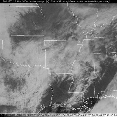
This composite from the SPC shows the visible satellite imagery and any severe weather watches. There is a tornado watch out in SE TX/W LA, but our focus is on the cloud cover. Any breaks in the clouds would result in higher instability - when the sun heats the surface of the Earth, that warms the air near the ground. Warming the lowest levels of the atmosphere is one way to create higher instability. The good news is that we don't see many breaks at all around here this morning. We'll be monitoring the satellite imagery closely today!
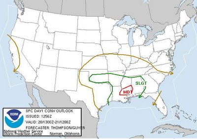
This is the latest Day 1 Outlook from SPC (the complete discussion and graphic suite is available by following the link in my discussion above these images...

This is the approximate position of the warm front at 9:00 AM. As this moves northward, our threat for severe weather will increase. The numbers by each station are the temperature (in red) and the dewpoint (in green). Note the warm dewpoints south of the warm front (the red line).
Moderate Risk
* As advertised, it's time to talk a little severe weather. I figured I would wait until the new Day 1 outlook from the Storm Prediction Center came out so we could do a little comparing/contrasting. Feel free to check out that forecast by clicking the link below. I will be mentioning several things about that forecast
SPC Day 1 Outlook* As you can see, we are under a "moderate risk" for severe weather. The one type of severe weather that sticks out is the probability for tornadoes. The forecaster mentions the threat of long track and significant tornadoes a possibility in the moderate risk area. You'll note that the moderate risk area is basically centered around our viewing area
* Our forecast is close to that, but just a little bit south of there. I do agree that there can be some intense supercells and tornadoes. Recent research from Justyn Jackson at Mississippi State suggests that tornadoes in the Deep South (specifically significant tornadoes) depend more on shear than instability. There will be an incredible amount of shear tomorrow, so it is conceivable that if storms go they will likely rotate. The fact of the matter is that we will need some form of instability to go along with the shear and that will come south of the warm front. Where will the front set up? That, my friends, is the million dollar question. The SPC is a firm believer that it will set up somewhere near the Natchez Trace and the NWS in JAN is going with that too. It will be interesting to see what role the on going MCS will have on things tomorrow. That could help enhance the front and bring it north of I-20. Right now, we'll stick with I-20 but we may revise that if it looks like the front will move on north of there. As of tonight it looks like the front is having a hard time moving north.
* What does all this mean? We should all pay attention to the weather. The front could easily race northward and line up with the SPC's prediction and we could all be under the gun. The best idea here to be prepared in the event we have severe weather. Review your severe weather action plan and check the batteries in your NOAA weather radio.
* A lot of severe weather requires NOWcasting rather than forecasting. This simply means that we have to see what satellites show in the morning and where the front is located and things like that. Once we can evaluate how our computer models are handling the situation, we can go from there. Be sure to check this blog frequently tomorrow as well as watch Charles Daniel and Josh Johnson who will be here all day. I will be taking my written comprehensive exams for my Masters Degree as well as trying to keep an eye on things!
Sunday Afternoon
* Let me first say that I may possibly be the worst "bracketologist" ever. After a highly successful first day, I have gone nowhere but downhill. Thank you Kansas for busting my bracket.
* Things sure are wet out there. While there are a few sporadic showers south of I-20, the vast majority of rainfall is north of I-20. The heaviest ban of rain now extends right along the highway 15 corridor. Most of us will pick up close to a half inch of rain this afternoon. But it looks like the heaviest rain will come tomorrow
* The threat still looms for severe weather tomorrow. As Josh mentioned previously, instability will be the main limiting factor. Should we see clouds mix out and a good amount of sunshine tomorrow, we could be in for a very busy day. I'd like to check out a little more model guidance and data before getting a real firm forecast together. I will be posting a severe weather discussion later this evening so be sure to check that out! The Storm Prediction Center continues their forecast for a slight risk across our area. The 30% hatched area represents the possibility of a few significant weather events to occur. To see that forecast, click the link below.
SPC Day 2 Outlook


