Cooler and Drier.......
Cooler temperatures are on the way!!!! I'll tell you what, I dont know if I could stand too many more 101 degree days! I was trying to clean the windows on my car Friday and my hand was burning it was so hot out. Well, the good news....come Monday we should be looking at temperatures dipping into the upper 80's with mild evenings in the mid 60's. Once this front associated with all of the rain pushes through, drier air should fill in behind it on northwesterly winds. It should be a pleasant work week! Try to get out and enjoy it as much as you can, even if that means riding with the windows down during your lunch break!
Flood and Drought...
* While parts of our area are still dry and facing drought-like problems, other parts are facing some flooding issues. NWS has issued a Flood Warning for Jones County...
There is a band of thunderstroms draped across southeast Mississippi and southwest Alabama, and it's not moving very much. Radar estimates over four inches of rain in this band. The greatest threat of flooding comes between Laurel and Collins. Be aware of rising waters, and do not EVER drive across moving water of unknown depth.
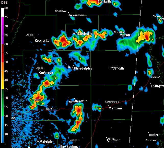
* There are no severe thunderstorm warnings, but we are still watching some strong storms with heavy rain, frequent lightning, and gusty winds...
SVR Marengo, Clarke, Jones
* Severe thunderstorm warnings continue for parts of Marengo, Clarke (AL), and Jones counties...
* Heavy storm approaching Linden in Marengo County...We will likely see some hail fall out of that storm.
* A cluster of strong thunderstorms continues over Choctaw County, but there is no formal severe thunderstorm warning. But, if you live in Choctaw County, plan on heavy rain, gusty winds, and frequent lightning to continue affecting your area over the next hour or so.
Storm Reports
* Getting reports of hail falling around our area...Nickel size hail fell near York, AL earlier today...And, a few minutes ago, nickel to quarter size hail fell in northern Clarke County, near Enterprise..
SVR Warnings
* We have several severe thunderstorm warnings...
Clarke (MS)
Lauderdale (MS)
Leake (MS)
Clarke (MS)
These warnings are for pulse-type storms...Lightning will be a big threat, along with some small hail and gusty winds. Stay indoors and away from windows...
Rain and Storms

* Rain and a few thunderstorms have developed this afternoon across central Mississippi and central Alabama...
* The strongest cells are in southwest Winston, northern Scott, southern Newton, northern Jasper and northern Jones Counties...More powerful storms are popping up in west Alabama as well...
Podcast: Thursday Edition
* This is the Newscenter 11 Podcast - a forecast designed for the increasingly popular IPods! This product can also be played on most personal computers. It's a great way to get extra forecast and weather content at your convenience.
* In today's podcast, I talk about our rain chances over the weekend..Check it out:http://media.graytvinc.com/audio/Podcast1.mp3* You can point your IPod or MP3 receiving program to this RSS feed in order to subscribe:
http://feeds.feedburner.com/11Podcast
Houston Floods...Mobile Drought
* One of my professors at Mississippi State always likes to say that it's either feast or famine when it comes to weather (and rain in particular) in the South. That professor is Dr. Charles Wax, and he also serves as State Climatologist. Dr. Wax is a great guy and a great professor, and his words are better than mine....Feast or famine.
Those words were the first thing that came to my mind after seeing the images of flooding from Houston yesterday. A day's drive west of there, and people are begging for some rain. Typical weather in the Southeast, that's for sure.
* So what about rain chances here? Unfortunately, they sure look slim. A weak upper trough is forecast to slide north of here around the end of the week, and this will bring a few scattered showers and storms...We'll keep our fingers crossed.
* Speaking of the feast or famine perspective, you could apply that to east Mississippi yesterday as well. Heavy rain and thunderstorms affected a large part of our area, but many neighborhoods stayed bone dry. That's just the nature of those summertime storms.
Podcast: Tuesday Edition
* This is the Newscenter 11 Podcast - a forecast designed for the increasingly popular IPods! This product can also be played on most personal computers. It's a great way to get extra forecast and weather content at your convenience.
* In today's podcast, I talk about the difficulty of forecasting summertime thunderstorms..Check it out:http://media.graytvinc.com/audio/Podcast1.mp3* You can point your IPod or MP3 receiving program to this RSS feed in order to subscribe:
http://feeds.feedburner.com/11Podcast
Podcast: Monday Edition
* This is the Newscenter 11 Podcast - a forecast designed for the increasingly popular IPods! This product can also be played on most personal computers. It's a great way to get extra forecast and weather content at your convenience.
* In today's podcast, I talk briefly about the relationship between DRY weather and HEAT..Check it out:http://media.graytvinc.com/audio/Podcast1.mp3* You can point your IPod or MP3 receiving program to this RSS feed in order to subscribe:
http://feeds.feedburner.com/11Podcast
Drenching Rain!
Places along the MS valley are seeing some drenching rain today. Memphis and surrounding counties are getting hammered with heavy rainfall and a couple of places are even under flash flood warnings this afternoon. The system itself has very distinct northerly component, where showers move almost from south to north with a very slow eastward progression.The ground up there is already very saturated from showers and storms yesterday and therefore, the rain today is causing major problems in some areas. Closer to home, we have started off the day with a mix of clouds and sun. However, scattered showers are slowly making their way into our area. I dont expect hardly any of these storms to go severe. However, I can't rule out one or two severe thunderstorm warnings being issued later on. These storms are going to be the normal afternoon showers in Mississippi!! Carry an umbrella this afternoon and tonight if you are taking your dad out for dinner just to be safe. Also, be sure to slow it down on the roads if you end up driving through heavy rain! Have a great Sunday! See you guys next weekend!