Things Winding Down
After an action packed and busy weather day, things appear to be winding down in our area. The greatest tornado threat has shifted northwestward towards the Mississippi Delta region. Because of this, the Storm Prediction Center has issued a new tornado watch for that area and has allowed our watch to expire at 9pm.
We still may see some showers and thunderstorms overnight and into tomorrow as a lot of tropical moisture is still in place. Some could be strong and an isolated tornado is possible, but the main threat is elsewhere.
Newton County Storm
As of 7:40 a stronger thunderstorm was moving through Newton county and the town of Newton. While there is no official warning on this storm, it is strong and those in the area should use precaution. Heavy rain, small hail, and dangerous lightning are possible with this storm.
Stormy Afternoon
Two tornado warnings were issued for the far western portions of Scott and Smith counties. The storm in Scott county had a very good rotational signature on it and may have well produced a tornado...no reports yet.
Another storm is over the Meridian area and moving northward rapidly. This has shown signs of rotation, but not enough for the National Weather Service to issue a warning. It certainly bears watching...
We'll be here all night updating the blog and cutting in to programming as warnings come in....
TOR Warning for Leake
Another tornado warning has been issued for Leake County until 2:45. This is doppler indicated rotation within the storm. This storm is expected to move just to the east of Carthage. The storm is moving north at 45 mph.
2:00 pm update
New Severe Thunderstorm Warnings for eastern Winston and Noxubee counties in MS until 2:45 pm. Main threats here are penny sized hail, heavy rain, and wind gusts to 60 mph...
Back to radar...
Busy Radar
We have had a few tornado warnings so far this afternoon in Scott, Smith, and Leake counties. As will be the case with most of the storms today, these show signs of rotation very low in the storm due to strong low level wind shear and therefore the National Weather Service issues a warning. No reports of tornadoes thus far...
The majority of our area is still under a tornado watch and will be for most of the evening. These storms are very small - termed "mini supercells" - which form along the feeder bands of Tropical Cyclones (Rita). While tornadoes are very dangerous, we do expect any tornado that forms to be very brief and weak...
Aside from the storms in Scott, Smith, and Leake counties, another strong band of showers and thunderstorms was located from Noxubee county southward through Kemper, northern Lauderdale, and into Sumter and Marengo counties in Alabama. We can expect very heavy rain, lightning, and wind gusts up to 40 mph.
JUST IN:
* SEVERE THUNDERSTORM WARNING FOR...
 KEMPER COUNTY IN EAST CENTRAL MISSISSIPPI

* UNTIL 230 PM CDT

* AT 138 PM CDT...NATIONAL WEATHER SERVICE DOPPLER RADAR INDICATED A
 SEVERE THUNDERSTORM CAPABLE OF PRODUCING PENNY SIZE HAIL...AND
 DAMAGING WINDS IN EXCESS OF 60 MPH.  THIS STORM WAS LOCATED 10
 MILES SOUTH OF DE KALB...OR ABOUT 6 MILES NORTH OF MERIDIAN
 STATION...AND MOVING NORTHWEST AT 55 MPH.

* THE SEVERE THUNDERSTORM WILL BE NEAR...
 DE KALB BY 145 PM CDT
Tornado Watch
The Storm Prediction Center (SPC) in Norman, OK has issued a Tornado Watch until 5pm CDT for the following counties:
Clarke
Lauderdale
Jasper
Neshoba
Kemper
Scott
Smith
Wayne
Jones
Choctaw (AL)
Leake
Newton
Will be watching the radar all day long... Be sure to watch the FirstWarn alert and our crawl on Newscenter 11 throughout the day as well as frequent updates on the blog for more information. We do not expect numerous tornadoes and will most likely see more warnings issued than actual tornado reports. In tropical systems, most tornadoes are weak and brief.
Rita Moving Onshore
* The leading edge of the eyewall of Hurricane Rita is set to move onshore in western Louisiana. This hurricane will bring devastating flooding and winds to much of southwest Louisiana and southwest Texas - the threat of inland flooding is also particularly high with this storm. More people die as a result of inland flooding than any other facet of hurricanes.
* How will this affect us? We'll break it down into categories:
Tropical Wind: Not a factor - winds gusting perhaps as high as 20-25 mph. Winds could be higher within thunderstorms in feeder bands.
Flooding: Not a significant factor - model guidance suggests that most of our area will not see enough rain to cause any problems. There will be some higher rainfall totals within thunderstorms, but the threat of flooding is very small.
Tornadoes: There is a small chance of a few brief tornadoes as part of feeder bands. These will be very brief and are usually weak. I would imagine we'll see many more tornado warnings than actual tornadoes.
The bottom line is that this will NOT have an impact the scale or magnitude of Katrina or Ivan. A few thunderstorms in feeder bands, a breeze in the air - that's about the extent of it.
* Renny Vandewege will be coming in early tomorrow, we will be staffed in the event of any developments. Also, be sure to watch the FirstWarn map and crawl system for weather watches and warnings!
Rita Bearing Down
* Been a very busy day today (I suppose its formally "yesterday") - began by meeting up with a truckload of supplies courtesy of our friends from Canada. One-third of the supplies were unloaded at Wesley House in Meridian, while the rest of the shipment was taken to the Mississippi Gulf Coast later in the afternoon. Certainly want to pass along our thanks to the folks who made the shipment possible...
* Rita is maintaining its' strength as it plows through the Gulf of Mexico. All indications are that it will make landfall somewhere along the upper Texas or southwest Louisiana coastline late Friday or early Saturday. If this track verifies, we will not have much of an impact on our weather - a little breezy, some showers and thunderstorms, but certainly nothing on the scale of what we saw with Ivan, Dennis, or Katrina. The greatest threat here would come in the form of isolated tornadoes associated with the outermost feeder bands from Rita. That's something we'll watch.
* Here is the latest VORTEX report from the recon flight:
000
URNT12 KNHC 230618
VORTEX DATA MESSAGE
A. 23/06:02:10Z
B. 26 deg 28 min N
090 deg 42 min W
C. 700 mb 2441 m
D. NA kt
E. NA deg 000 nm
F. 217 deg 113 kt
G. 134 deg 022 nm
H. 924 mbI. 14 C/ 3043 m
J. 17 C/ 3048 m
K. 15 C/ NA
L. CLOSED
M. C32
N. 12345/ 7
O. 0.02 / 1 nm
P. AF309 2018A RITA OB 28
MAX FL WIND 132 KT NE QUAD 03:31:30 Z
FL TEMP 18 C, 131 / 12NM
EYEWALL THIN E-SW* Rita continues to go through eyewall replacement cycles. These seem to be inhibiting much intensification. Also aiding in the lack of intensification is the fact that Rita has been traversing over some cooler water in the Gulf. It will soon move back over warmer water, however, and some slight strengthening is possible during the next 6-9 hours. After that, it will begin to approach the coastline and a slow weakening trend should begin. However, all indications are that Rita will make landfall as at least a Category Three, perhaps a Category Four hurricane. Also, it will have surge consistent with a Cat 5. So, if you have friends or family along the TX/LA coastline - between Galveston and Morgan City, Louisiana, please urge them to evacuate as soon as possible. Time is running out for evacuations.
*

Model guidance has shifted slightly eastward this morning. Best chance of landfall appears to be Beaumont, Texas to near Houston...

Rita Very Scary...
* Allow me to post the latest VORTEX report from the last recon flight. Notice the remarks at the bottom:
000
URNT12 KNHC 220559
VORTEX DATA MESSAGE
A. 22/05:38:00Z
B. 24 deg 46 min N
087 deg 34 min W
C. 700 mb 2218 m
D. NA kt
E. NA deg nm
F. 139 deg 165 kt
G. 063 deg 012 nm
H. 898 mb
I. 9 C/ 3044 m
J. 28 C/ 3047 m
K. 3 C/ NA
L. CLOSED WALL
M. C16
N. 12345/ 7
O. 0.02 / 1 nm
P. AF307 1618A RITA OB 04
MAX FL WIND 165 KT NE QUAD 05:34:00 Z
FREQUENT LIGHTNING
MODERATE TURBULENCE IN EYEWALL
EXTREMELY IMPRESSIVE STADIUM EFFECT IN MOONLIGHT* That means winds at flight level (few thousand feet above the ground) were 190 mph! A truly unbelievable figure. Also note the presence of lightning - this allows those strong flight level winds to reach the surface. They also mention a stadium effect in moonlight. I can hardly imagine how that must look. The "stadium effect" is when the eyewall is bowl-shaped, arcing outward as you rise from the ocean into the atmosphere. All of this points to a very scary hurricane.
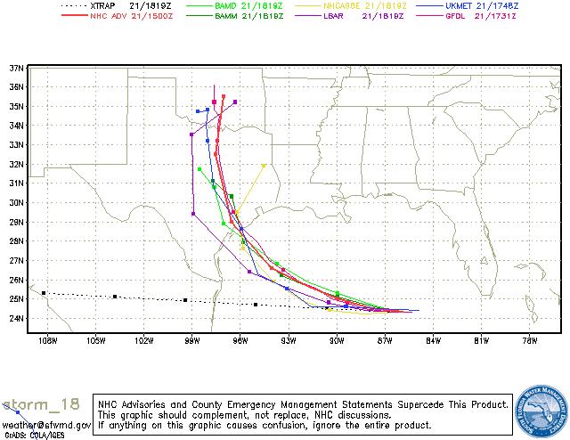
* Still awaiting the complete set of 6z model guidance. The UKMET and GFDL models have both shifted eastward...The UKMET wants to bring the system into western Louisiana, while the GFDL scores a direct hit on Houston. Still too early to lock down the track. Satellite images suggest the hurricane is doing quite a bit of wobbling.
* Will update again later this morning...
Rita Soon To Be a Category 5
* Just about to begin coordination conferences with the National Hurricane Center. They are going to upgrade Rita to a Category Five hurricane with their 4:00 pm forecast package. Maximum sustained winds within Rita have increased to 165 mph, with higher gusts.
* We must also continue to watch Rita like a hawk. While all available evidence points to a Texas landfall, this track is not written in stone. Wherever it ends up striking the coast, that area will not be the same for years - historic destruction is possible. This is a very serious situation for the Texas coast - our prayers are certainly in order for our neighbors.

Model guidance all suggests Rita is heading for the Texas coast.
Rita Looking Spooky...
* It's hard to believe, but we are only 5 mph away from having 2 Category Five hurricanes in the Gulf of Mexico in a month's time. Rita is now a very strong Category 4 storm, with maximum sustained winds of 150 mph. Minimum pressure is down to a startling 920 millibars - very, very low. For reference, Katrina reached a minimum of 902 millibars out in the Gulf - but had risen to 919 millibars at landfall.
* At its' current pressure, Rita is the 4th strongest hurricane on record in the Gulf of Mexico. It is behind only Katrina, Camille, and Opal. So, it's apparent that this storm will make its own history.
* Our track reasoning hasn't changed much - unless something drastic changes, this will mostly be a non-event for us. Perhaps a few squalls with rain and gusty winds, but even that seems to be a stretch this far east. We would be fortunate to receive the rain though - we are still well below normal for September.
* Again, we want to emphasize the uncertainty. While our computer model guidance is in good agreement that Rita will strike the Texas coast, it is too early to give an "all-clear" to any coastal area between Morgan City, Louisiana and Brownsville, Texas. We must watch Rita closely, because wherever it hits will have catastrophic damage.
* Given the fresh memories of the suffering caused by Hurricane Katrina, I hope and believe that people along the Texas coastline will take Rita very, very seriously. If you have friends or family that live along the Texas coastline, you might consider calling them and making sure that they are watching it very closely. This will be yet another historic hurricane.
Early Afternoon Rita Update
* Rita is really beginning to get its' act together - now a Category 2 hurricane packing sustained winds of 100 mph. The weather in the Florida Keys is beginning to go downhill. Here are a few spot reports from south Florida as of 2 PM CDT:
Key West Int'l Airport: Light Rain, Winds: E 39 MPH, Gusts to 54 MPH.
Boca Chica Naval Air Station: Light Rain, Winds: E 47 MPH, Gusts to 62 MPH.
Miami: Light Rain, Winds: E 25, Gusts to 36 MPH.
Sombrero Key: Winds: E 62 , Gusts to 72 MPH
Marathon: Light Rain, Winds: E 28, Gusts to 45 MPH.
* Rita will likely continue to intensify quickly out over the warm waters of the Gulf of Mexico. There is little shear, and only a small amount of dry air for the system to encounter.
* The track guidance from our computer models continues to indicate that the greatest probability of landfall will come along the Texas coastline, somewhere between Houston and Brownsville. The 12z (morning) run of the tropical models is very tightly clustered and in good agreement with this scenario. But, as the disclaimer states, this track is far from being written in stone. Check back for updates...
You Can Help; Rita Update
* I'm quickly becoming less of a fan of Monday Night Football. I loved it in college, but now that I'm having to stay at work until after midnight each Monday, it's not nearly as fun.
* Quick update - John Grisham has given $5 million of his own money to start a fund that will help the Mississippi Coast. In all of the horror of what has happened in New Orleans, I fear that the catastrophe on the Mississippi Gulf Coast is being forgotten. We can all help out our neighbors along the coast. Every dollar helps...
http://www.rebuildthecoastfund.org/* Rita will soon become a hurricane. It's really hard to believe we are already at the "R" storm for this year. Pretty historic stuff. Rita will likely impact the Florida Keys in a significant way - especially Key West. Mandatory evacuations continue for the Keys - if you know anyone down there, give them a call and tell them to leave. The Keys are not a good place to be during a hurricane.
* Rita will eventually move into the central Gulf of Mexico, likely becoming a major hurricane as it makes its' journey westward. The prime area of concern according to the computer model guidance and our own thorough analysis of the weather pattern seems to be between Galveston, Texas and Morgan City, Louisiana. Obviously, a lot can change between now and then - this forecast is FAR from written in stone. Needless to say, everyone along the Gulf Coast should closely monitor the progress of Rita in coming days.
* Will post another update tomorrow around noon.
TS Rita
Tropical Storm Rita has formed in the Atlantic with winds of 40 mph. It is moving westward. While a direct landfall in Florida does not appear to be the case, Rita will move close enough to the keys that Hurricane Watches have been issued for there and for Cuba.
I have increasing concerns for people on the western Gulf Coast. Rita will be encountering a very favorable environment for rapid intensification and should become a hurricane in the next day or two. Once it gets into the Gulf of Mexico it should continue to move west for several days.
Our weather is going to get hot the next few days, and while most of us are looking for cooler weather, this warming trend could be a blessing. The warmth will come from a "heat bubble" high pressure system that will settle on top of us for a few days. As we've mentioned during previous tropical activity, high pressure systems act as a "buffer" to steer tropical systems around them. In this particular situation, Rita should move around the periphery of the high towards the Texas or Mexican coast. As we always mention, however, tropical systems are difficult to forecast so we will be watching this system very closely over the next several days which will allow us to refine our forecast.