Nice Sunday
* Things are shaping up for a beautiful Sunday afternoon as highs reach the middle 80s underneath sunny skies. Winds will be light out of the south at 5-10 mph. We may be dealing with a little patchy fog overnight tonight but things should be clear by 9 or 10am
* Dry and warm weather continues through Monday. Changes begin Tuesday as we introduce new chances of rain with our next front moving through. We really cool off by the end of the week as temperatures get back down to the mid 70s.
* Have a great Sunday!
Category Five?
* I certainly hope this is no sign of things to come for our hurricane season. Category Five "Severe Tropical Cyclone" Monica is bearing down on Australia tonight...
http://thestormtrack.com/archives/2006/04/category_5_moni.html* The weekend looks great - plenty of sunshine tomorrow. Some small rain chances roll around next week.
* Have a great weekend, and spend some time with your family.
Tornado Report
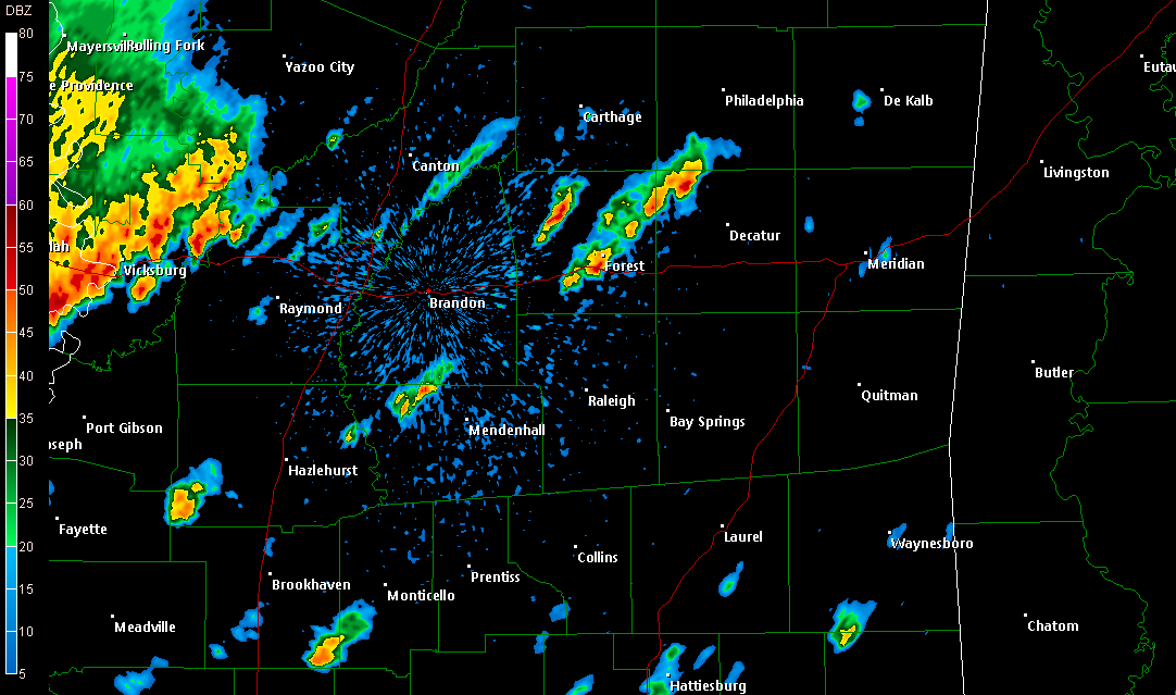
* There has been a report of a tornado over in northern Simpson/northern Smith County...near the communities of White Oak and Heater...There was no warning in effect for either county, so we were not on in coverage.
* The storms have died down a bit -- but still, expect some frequent lightning and downpours in parts of Jasper, Clarke (MS), and Sumter Counties over the next hour or so.
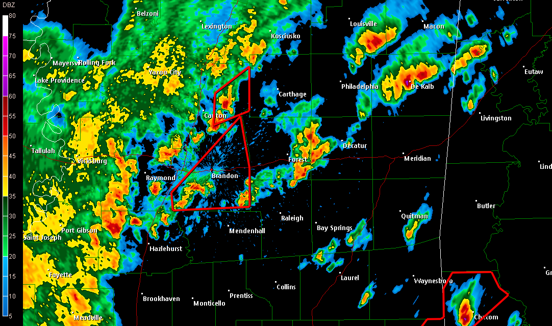
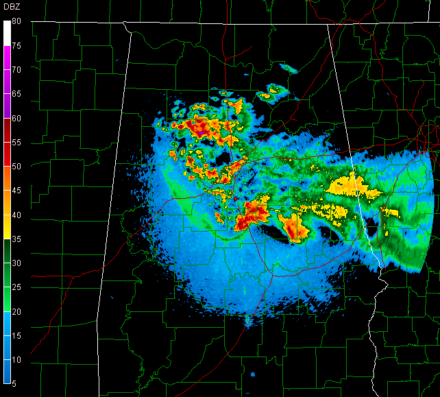
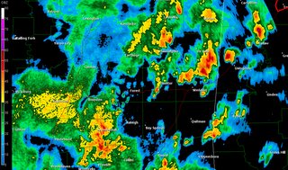
10:00 PM Radar Update
* NOTE: You may click the above image for a larger version.
* A few thunderstorms have developed back to our west, near Jackson. These storms are pushing towards the ESE, and will sweep through parts of Scott, Smith, Newton, and Jasper counties over the next couple of hours. Eventually, these could affect Clarke County, before pushing on into west Alabama. These storms will not be severe, but we cannot rule out some small hail in some of the stronger cells.
Severe T-Storm Watch Update
* The Severe Thunderstorm Watch has been cancelled for all of our Mississippi counties, and Pickens, Choctaw, and Clarke counties in west Alabama. The watch remains in effect for Sumter, Greene, Hale, and Marengo counties. I anticipate that these counties will be removed from the watch within the next couple of hours.
* Right now, the worst of the weather is primarily in Alabama. Even there, the weather is not that bad - heavy rain and frequent lightning. However, there is a band of thunderstorms strengthening over parts of Covington County (MS), these will sweep into roughly the northern half of Jones County over the next hour or so.
4:40 PM Radar Update
* New storms are firing back across Jasper County...Still no severe weather warnings. Heavy rain has temporarily ended in downtown Meridian.
* RODEO WEATHER: The big rodeo is tonight, and there will be a risk of showers and thunderstorms in Lauderdale this evening. So, bring along the rain gear just in case. At this point, it seems that the heaviest rain will likely move east of here by the time the rodeo gets going tonight.
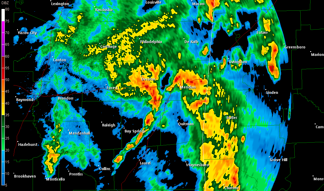
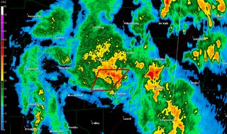
Storm Approaching Meridian
* A powerful (but non-severe) thunderstorm is approaching downtown Meridian...Hail is a good possibility within this storm, and torrential rain will fall with this storm as it passes through downtown.
* If you're out driving in downtown Meridian, please allow some extra time to reach your destination. Roads will be favorable for hydroplaning...Slow it down.
4:15 PM Update
*
Severe T-Storm Warning continues for Smith and Jasper Counties until 4:30 PM...
* A very strong storm is over northern Clarke County as we speak...Probably some hail in that one...It's passing over Clarkdale right now.
* PICTURES: If you have any weather pictures, e-mail them to me at weather@wtok.com!
Still Stormy..
* There are still a lot of thunderstorms in progress...Thankfully, no warnings are in effect...
* A band of strong storms is pushing through parts of northeast Lauderdale and eastern Kemper County. These storms are approaching the state line...Probably some small hail involved in these storms.
SVR Warning Wayne and Choctaw (AL)
* NWS Mobile has issued a
Severe T-Storm Warning for the storm over Waynesboro that I mentioned below..
* The warning runs until 3:15 pm.
Strong Storm Over Waynesboro
* No severe thunderstorm warning for it, but there is a rather strong storm moving over the northern part of Waynesboro...Some hail is likely with this storm on the north and northwestern side of Waynesboro...
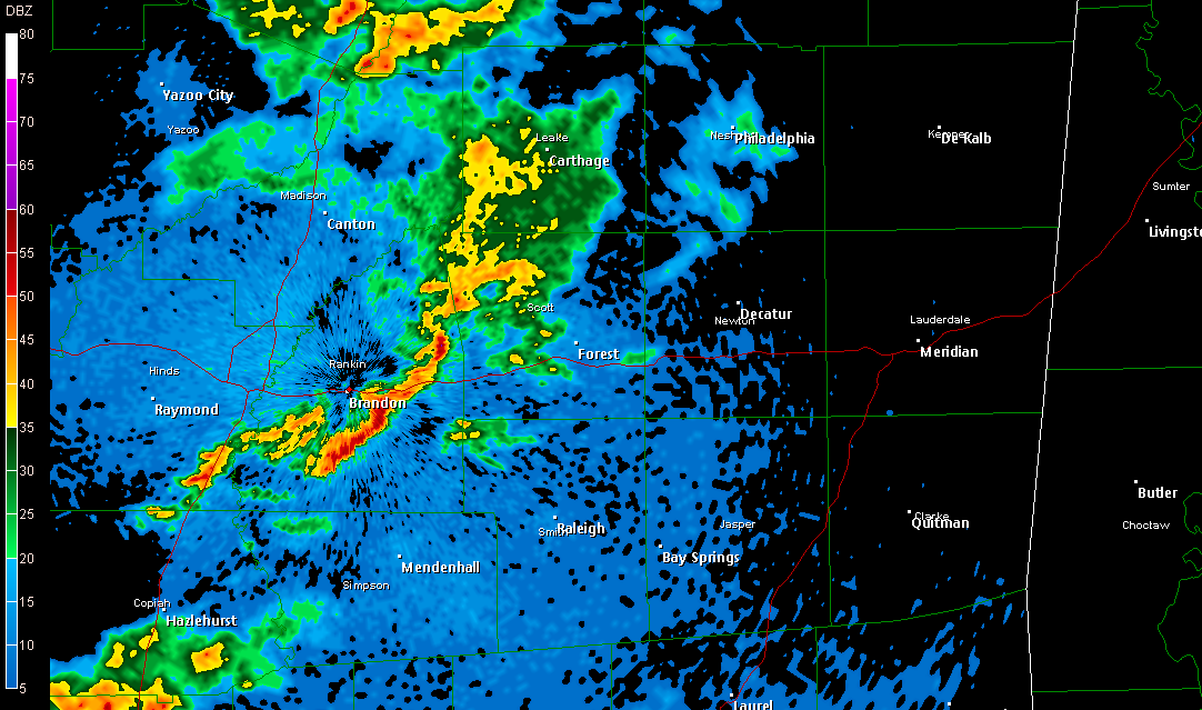
SVR Warning Scott
* NWS has issued a
Severe Thunderstorm Warning for Scott County until 3:15 PM...
* The worst of the storm is passing over Morton right now, and will move northeast, crossing Highway 35 between Forest and Harperville. Forest, Hillsboro, Harperville, and eventually Sebastopol will feel the effects of this storm.
* The main threat is large hail...
2 PM Update
* A
Severe Thunderstorm Warning continues for Clarke County, Alabama. That storm will stay mostly west of U.S. Highway 43, crossing Highway 84 between Coffeeville and Grove Hill. Large hail is the main threat.
* Other strong storms are scattered across our area...A strong one is affecting parts of Newton County, with others in Kemper, Noxubee, Clarke, and Jones.
* Back to watching the radar...
1:30 PM Update
* We've received reports of ping-pong ball size hail breaking out windshields near Canton...
* Scattered thunderstorms are popping across most of our area. Normally I try to highlight areas of thunderstorm development, but they are too numerous to mention.
* Our entire area is under a Severe Thunderstorm Watch now...
Severe T-Storm Watch 232
Severe T-Storm Watch 233* Late report of half inch diameter hail in Florence, MS...
New Mesoscale Discussion

* SPC has issued a "Mesoscale Discussion" -- these are technical but informal discussions of the expected progression of impending weather threats...
* This one includes most of our west Alabama counties...
* Here's the discussion that accompanies the graphic above (you may click that image for a larger version):
SLOW INCREASE IN CONVECTIVE DEVELOPMENT IS ALREADY ONGOING. THIS SHOULD INTENSIFY FURTHER THIS AFTERNOON. TRENDS ARE BEING MONITORED FOR AN INCREASING SEVERE THREAT...AND THE POSSIBILITY OF A WW.
INITIAL SOUTHERN BRANCH IMPULSE CONTINUES TO LIFT NORTHEASTWARD THROUGH THE UPPER TENNESSEE VALLEY. 50+ KT 500 MB JET STREAK SEEMS TO BE ACCOMPANYING THIS FEATURE...AND MAIN CONVECTIVE DEVELOPMENT ASSOCIATED WITH STRONGER MID-LEVEL FORCING IS BEGINNING TO SHIFT TOWARD THE UPPER OHIO VALLEY/NORTH CENTRAL APPALACHIANS. HOWEVER...IN WAKE OF THIS FEATURE...AND AHEAD OF LOWER MISSISSIPPI VALLEY SHORT WAVE TROUGH...CONFLUENT LOW-LEVEL REGIME MAY BECOME FOCUS FOR INCREASING THUNDERSTORM ACTIVITY INTO THE 19-20Z (2-3 PM) TIME FRAME.
MOIST BOUNDARY LAYER FROM THE WESTERN SLOPES OF THE SOUTHERN APPALACHIANS INTO NORTHERN ALABAMA IS DEEPENING WITH INSOLATION. AS TEMPERATURES APPROACH THE LOWER 80S...MIXED LAYER CAPE IS EXPECTED TO EXCEED 1000 J/KG. THIS SHOULD BE SUFFICIENT FOR VIGOROUS UPDRAFTS IN FAVORABLY SHEARED ENVIRONMENT FOR MID-LEVEL UPDRAFT ROTATION. LARGE HAIL MAY BE PRIMARY SEVERE THREAT.
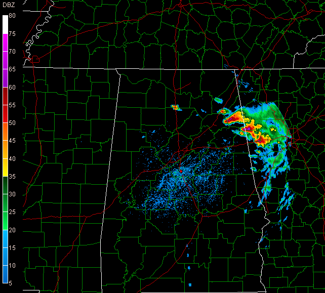
Radar Update: 11:55 AM

* Showers and thunderstorms are beginning to develop across parts of central Mississippi...None of these are severe yet, but they are intensifying and moving into a favorable environment for continued strengthening.
* NOTE: Click the radar image above for a larger version.
Severe T-Storm Watch
* SPC has issued a
Severe Thunderstorm Watch for many of our Mississippi counties. The watch runs until 4 pm, and includes these counties in our area:
MISSISSIPPI
Leake
Neshoba
Kemper
Scott
Newton
Lauderdale
Smith
Jasper
Clarke
No Alabama counties are in this watch. More watches will likely be issued later today, and these will include parts of Alabama.
* The threat of thunderstorms and severe weather here today is much, much greater than the previous two days. Large hail will be the main threat. I wouldn't be surprised if we saw reports of hail to the size of golf balls.
Another Pic...

* Here's another picture Renny took of the same storm...Pretty distinct wall cloud!
North Mississippi Storms...

* Our own Renny Vandewege took this picture a while ago, just east of Columbus Air Force Base...The storm is producing very large hail, and that picture also suggests that this storm had a wall cloud...
* Still nothing going on around our immediate area...
Severe T-Storm Watch
* A
Severe Thunderstorm Watch has been issued for much of northern Mississippi. It runs until 9:00 pm...It includes Winston and Noxubee counties in our area.
* This goes along with a previous
Severe Thunderstorm Watch issued for northern and central Alabama. It includes Pickens County in our area.
* I'm not entirely convinced that these watches should extend as far south as our area. But, I have been wrong before, and I'll be wrong again. We'll be watching the radar...The more substantial threat for severe thunderstorms comes tomorrow.
No Storms Yet
* Thunderstorms have been slow to develop across Mississippi and Alabama this afternoon. While they haven't formed yet, a few storms will probably get going later this afternoon. Whether or not they affect us remains to be seen. Any storms that do develop have the potential to produce large hail. It should be stressed that some, if not most communities in our area will likely stay dry.
* In my opinion, tomorrow will bring a more substantial risk of severe weather. Thunderstorms will develop and move through our area, and the risk of large hail will be significant. The SPC has a Slight Risk up for us tomorrow.
* Back to watching the radar...Some storms developing out in eastern Arkansas...
Podcast: Thursday Edition
* This is the Newscenter 11 Podcast - a forecast designed for the increasingly popular IPods! This product can also be played on most personal computers. It's a great way to get extra forecast and weather content at your convenience.
* Today's podcast includes discussion of factors that produce large hail. And, of course, we talk about your latest forecast...Check it out:http://media.graytvinc.com/audio/Podcast1.mp3* You can point your IPod or MP3 receiving program to this RSS feed in order to subscribe:
http://feeds.feedburner.com/11Podcast
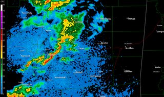
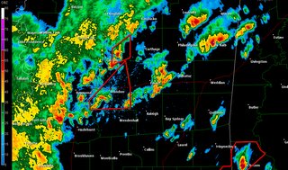
Radar Update

* A few notes about the image...Check out the outflow boundary -- it's the thin green line ahead of the thunderstorms....curving from roughly Clanton, Alabama back through Tuscaloosa County. That boundary will be a focus for thunderstorm development tomorrow...
T-Storm Watch Update...
* The SPC has dropped a few counties from the Severe Thunderstorm Watch -- Leake, Neshoba, and Kemper counties are no longer included.
* The watch continues until midnight for the following counties:
MISSISSIPPI
Winston
Noxubee
ALABAMA
Pickens
Sumter
Greene
Hale
Marengo
Severe T-Storm Watch
* The SPC has issued a
Severe Thunderstorm Watch for parts of our area. The watch includes the following counties:
MISSISSIPPI
Leake
Neshoba
Kemper
Winston
Noxubee
ALABAMA
Sumter
Marengo
Pickens
Greene
Hale
* The watch runs until midnight.
* Frankly, I don't know that the watch should extend as far south as it currently does. I believe the largest severe weather threat will likely stay along the Highway 82 corridor. But, just be aware that there is the possibility of some thunderstorms later. The main threat in any storms that do develop would come in the form of large hail.
* In fact, parts of Alabama have seen hail as large as baseballs earlier today...
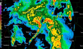
Whopper Size Storms -- NE Alabama
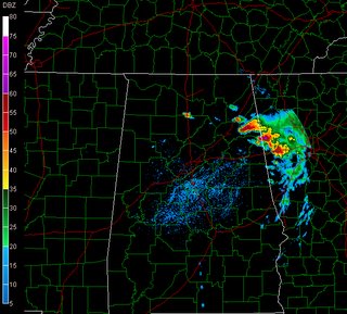
* Check out these storms over northeast Alabama...They are producing some really large hail over that part of Alabama...There have been reports of hail larger than golf balls with some of these thunderstorms.
* SPC has issued a severe thunderstorm watch for areas west of the Mississippi River. We believe that all of the thunderstorm activity will stay north of us today...But, we do expect an increase in thunderstorm activity
tomorrow and
Friday. Some of the storms could be severe, with large hail the main threat.
Podcast: Wednesday Edition
* This is the Newscenter 11 Podcast - a forecast designed for the increasingly popular IPods! This product can also be played on most personal computers. It's a great way to get extra forecast and weather content at your convenience.
* Today's podcast includes talk about the potential for a summer heat wave and/or drought. And, of course, we talk about your latest forecast...Check it out:http://media.graytvinc.com/audio/Podcast1.mp3* You can point your IPod or MP3 receiving program to this RSS feed in order to subscribe:
http://feeds.feedburner.com/11Podcast
Storms Tomorrow?
* The Storm Prediction Center has outlined the northern part of our area under a Slight Risk for severe weather tomorrow. My opinion is that most of our area will stay dry. But, I suppose we can't rule out a scattered thunderstorm or two along and north of rougly I-20. Any storms that get going could be severe, with large hail and gusty winds the main threats.
* Otherwise, we still anticipate a change to slightly cooler weather. Model guidance suggests that a trough will eventually develop in the eastern U.S., and this will allow some cooler air to slip into the Southeast. Highs this weekend into early next week will likely reach the upper 70's and lower 80's.
* WEEKEND: While we will likely see a few scattered thunderstorms, I should stress that it will not rain all weekend. In fact, some places could stay fairly dry. But, there will be a few showers and storms affecting some neighborhoods. It will be similar to what we see in summer.
Podcast: Tuesday Edition
* This is the Newscenter 11 Podcast - a forecast designed for the increasingly popular IPods! This product can also be played on most personal computers. It's a great way to get extra forecast and weather content at your convenience.
* Today's podcast includes a discussion of the force that causes wind. And, of course, we talk about your latest forecast...Check it out:http://media.graytvinc.com/audio/Podcast1.mp3* You can point your IPod or MP3 receiving program to this RSS feed in order to subscribe:
http://feeds.feedburner.com/11Podcast
Podcast: Monday Edition
* This is the Newscenter 11 Podcast - a forecast designed for the increasingly popular IPods! This product can also be played on most personal computers. It's a great way to get extra forecast and weather content at your convenience.
* Today's podcast includes important information about a government grant program that could help you buy a storm shelter. And, of course, we talk about your latest forecast...Check it out:http://media.graytvinc.com/audio/Podcast1.mp3* You can point your IPod or MP3 receiving program to this RSS feed in order to subscribe:
http://feeds.feedburner.com/11Podcast