Rain Approaching

* Thunderstorms are beginning to approach the western parts of our viewing area. These thunderstorms will overspread much of east MS and west AL through the evening and overnight hours tonight. The rain will be heavy at times, and a few of the storms could be strong. A Tornado Watch is in effect for coastal Mississippi, but does not include any of our viewing area.
* Want to track the storms yourself? Check out our radar imagery on the web:
Base Reflectivity Still ImageStorm Relative Velocity Still ImageJava Radar Looper - includes animations of reflectivity, velocity, and rainfall estimates - click
HERE to check it out!
* Charles Daniel will be in this evening at 6pm and 10pm with a complete forecast update...
Weekend Thoughts..
* Running short on time, just wanted to post a quick update on here...
* Still looks like we'll be dealing with some wet times over the weekend. The good news is that it seems that we'll get a mostly dry day tomorrow -- only a few scattered thunderstorms.
* Much better rain chances arrive late tomorrow night. An MCS (Mesoscale Convective System) will move through...These are basically just clusters of thunderstorms. Heavy rain, gusty winds, and perhaps some small hail will be possible with these storms. But, the threat of severe weather seems fairly small.
* Rain will linger for Sunday morning, but we'll dry out by Sun. PM. Dry weather will remain for Monday, but rain chances increase again by the middle of next week.
Podcast: Friday Edition
* This is the Newscenter 11 Podcast - a forecast designed for the increasingly popular IPods! This product can also be played on most personal computers. It's a great way to get extra forecast and weather content at your convenience.
* Today's podcast offers the latest on rain chances coming at the end of the week...Check it out:http://media.graytvinc.com/audio/Podcast1.mp3* You can point your IPod or MP3 receiving program to this RSS feed in order to subscribe:
http://feeds.feedburner.com/11Podcast
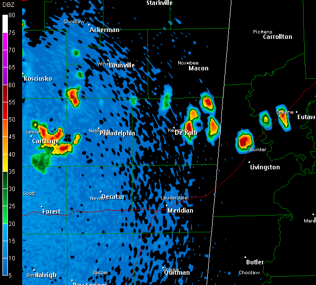
Storms Popping
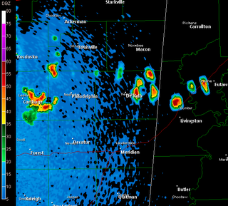
* Storms are developing across parts of our area...One cluster of storms is along the Leake/Neshoba county line, with another in southwestern Winston county. Also, more stormss are popping back over northeastern Kemper County, northern Sumter, and central Greene County (AL)....That storm is very near Eutaw.
Web Radar
* Quick reminder: you can use our new Radar looping tool on our website to track the progress of tonight's storms! Check it out:
http://www.wtok.com/weather/radarloopYou can get the still images at the following links:
Base ReflectivityStorm Relative Velocity* The storms are continuing to push east. It appears that they are beginning to wind down, but that's just a preliminary trend. We'll be watching.
* These storms will place outflow boundaries over our area, likely serving as a focus for thunderstorm development tomorrow..
* Back to watching the radar...
Tough Forecast Ahead
* The forecast is tough, and will only get tougher as we get closer to the weekend. First, today has been mostly dry. We have seen a few showers and storms pop up at times across east Mississippi, with more activity over in west-central Alabama.
* We'll take it day by day...
* TOMORROW: A cluster of thunderstorms forming right now will be tracking through east Mississippi and west Alabama by sunrise...This cluster of storms (called a Mesoscale Convective System or "MCS") will be dropping heavy rainfall, and some of the storms could be severe.
* TOMORROW NIGHT: Showers and thunderstorms will become less numerous, but we'll still be dealing with at least the chance of a few isolated showers and thunderstorms.
* SATURDAY: The latest guidance suggests that much of Saturday could be dry. However, I believe we'll see at least a few thunderstorms, especially during the afternoon and evening hours. As is the case with tomorrow, any of these storms could be briefly severe with gusty winds and/or some small hail.
* SATURDAY NIGHT: Rain and thunderstorms will overspread the area from the west again. It appears that we'll be dealing with a second MCS (Mesoscale Convective System) late Saturday night into Sunday morning.
* SUNDAY: The thunderstorms will affect us over the first half of the day, with drier air arriving later in the afternoon. This dry air will stay with us through Monday, with more rain and thunderstorms possible by Tuesday and Wednesday.
* I must stress that this is a tough forecast. Heavy rain sure seems like a good bet with these thunderstorm complexes we'll be dealing with, and a few strong or severe storms are also possible. Check back here for frequent updates...
Podcast: Wednesday Edition
* This is the Newscenter 11 Podcast - a forecast designed for the increasingly popular IPods! This product can also be played on most personal computers. It's a great way to get extra forecast and weather content at your convenience.
* Today's podcast offers the latest on rain chances coming at the end of the week...Check it out:http://media.graytvinc.com/audio/Podcast1.mp3* You can point your IPod or MP3 receiving program to this RSS feed in order to subscribe:
http://feeds.feedburner.com/11Podcast
A Special Day
* This post will not contain any weather information, but perhaps you'll get something out of reading it.
May 2, 1931 was a very special day in my life and in the lives of many of my family members and friends. My grandmother, Lucille G. Allen, was born. I wonder what her parents thought she'd grow up to be. Did they have any idea that their infant child would grow up to be an excellent mother, wife, grandmother, sister, and friend? Did they know that decades later, her grandchildren would grow to love the twinkle in her eye? How did they instill in her the devout belief that there is good in each and every person? However they did it, I'm just fortunate they got the job done.
Simply put, my grandmother was a treasure. She was one of those rare people whose paths we are truly fortunate to cross in life. She was also one of those people that cannot be accurately described by the English language. There really aren't the right words to convey the rich contribution she made to the people and environment around her. She was very kind, generous, honest, and always knew the right thing to say to teach the important lessons of life.
Like many children in their early teens, I sure thought I was smarter than my parents. This led to some friction with my mother, so I moved in with my grandmother. I lived with her for a little over two years, and those two years taught me volumes about life and how to treat people. Sadly, those two years were the last two of her life. She passed away of a heart attack in August 1996. She had awakened me early that morning and told me that she was having trouble, so I immediately called 911. But, by the time the paramedics arrived, she was already gone.
I have chosen not to mourn on the anniversary of her death. Rather, I try to celebrate her life on the anniversary of its' beginning. I can't think of a better way to spread her enthusiasm for life than to write this in the hope that it inspires someone to reach out to their loved ones.
Make sure you spend plenty of time with those you love. Regardless of age, arguments, concerns, bad blood, or any other thing that has been keeping you from reaching out to someone you care about, we all have one thing in common: we won't be here forever. Moments lost working, driving, dealing or busy with something else are lost and can't be restored. Try not to take people for granted, because they too will be gone one day.
Happy Birthday to my grandmother.
Podcast: Tuesday Edition
* This is the Newscenter 11 Podcast - a forecast designed for the increasingly popular IPods! This product can also be played on most personal computers. It's a great way to get extra forecast and weather content at your convenience.
* Today's podcast includes the many ways you can get weather info "on demand"...Check it out:http://media.graytvinc.com/audio/Podcast1.mp3* You can point your IPod or MP3 receiving program to this RSS feed in order to subscribe:
http://feeds.feedburner.com/11Podcast
A Case of the Mondays?
* No, I don't have a "case of the Mondays." But, I am a big fan of the movie Office Space...Great stuff.
* Anyway, on to the forecast. Things will be calm around here, as a storm system passes north of us. We could see a few thunderstorms as far south as Highway 82, but I can't really see those storms making it into our area tomorrow. We'll be watching it, but in all likelihood, we'll stay dry.
* The next chance of rain comes by late Friday and into early Saturday. An upper trough will be approaching, and this trough will spawn a surface low pretty much overhead. Rain and storms seems like a good bet, mainly Friday night into early hours of Saturday morning. We will try our best to nail down the details over the next few days...
Podcast: Monday Edition
* This is the Newscenter 11 Podcast - a forecast designed for the increasingly popular IPods! This product can also be played on most personal computers. It's a great way to get extra forecast and weather content at your convenience.
* Today's podcast includes talk about the month of May and the wide range of weather it can bring...Check it out:http://media.graytvinc.com/audio/Podcast1.mp3* You can point your IPod or MP3 receiving program to this RSS feed in order to subscribe:
http://feeds.feedburner.com/11Podcast
